Raubsville, Pennsylvania
| Raubsville, Pennsylvania | |
|---|---|
| census-designated place | |
| Village of Raubsville | |
 Location within Northampton county | |
 Raubsville Location within the state of Pennsylvania | |
| Coordinates: 40°38′08″N 75°11′35″W / 40.63556°N 75.19306°WCoordinates: 40°38′08″N 75°11′35″W / 40.63556°N 75.19306°W | |
| Country | United States |
| State | Pennsylvania |
| County | Northampton |
| Township | Williams |
| Population (2010) | |
| • Total | 1,088 |
| Time zone | Eastern (EST) (UTC-5) |
| • Summer (DST) | EDT (UTC-4) |
| ZIP code | 18042 |
| Area code(s) | 610 and 484 |
Raubsville is an census-designated place in Williams Township, Northampton County, Pennsylvania, located along Route 611 on the west bank of the Delaware River. It is served by the Wilson Area School District and uses the Easton zip code of 18042. The population of Raubsville was 1,088 residents as of the 2010 census.
 |
Glendon | Easton; Phillipsburg, New Jersey | Alpha, New Jersey | |
| Redington | |
Carpentersville, New Jersey; Warren Glen, New Jersey | ||
| ||||
| | ||||
| Coffeetown | Riegelsville | Hughesville, New Jersey |
Municipalities and communities of Northampton County, Pennsylvania, United States | ||
|---|---|---|
| Cities | 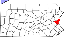 | |
| Boroughs | ||
| Townships | ||
| CDPs | ||
| Unincorporated communities | ||
| Footnotes | ‡This populated place also has portions in an adjacent county or counties | |
This article is issued from Wikipedia - version of the 9/4/2016. The text is available under the Creative Commons Attribution/Share Alike but additional terms may apply for the media files.