Belfast, Pennsylvania
- There is also a Belfast Township in Fulton County, Pennsylvania.
| Belfast | |
| Settlement | |
| Country | United States |
|---|---|
| State | Pennsylvania |
| County | Northampton |
| Elevation | 525 ft (160.0 m) |
| Coordinates | 40°47′0″N 75°16′35″W / 40.78333°N 75.27639°WCoordinates: 40°47′0″N 75°16′35″W / 40.78333°N 75.27639°W |
| Area | 1.1 sq mi (2.8 km2) |
| - land | 1.1 sq mi (3 km2) |
| - water | 0.0 sq mi (0 km2), 0% |
| Population | 1,257 (2010) |
| Density | 1,181/sq mi (456.0/km2) |
| Timezone | EST (UTC-5) |
| - summer (DST) | EDT (UTC-4) |
| ZIP code | 18064 |
| Area code | 610 |
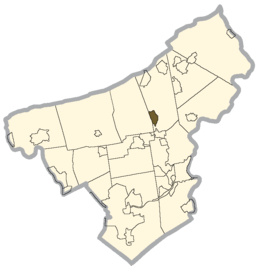 Location of Belfast in Northampton County
| |
 Location of Belfast in Pennsylvania
| |
 Location of Pennsylvania in the United States
| |
Belfast is a census-designated place (CDP) in Plainfield Township, Northampton County, Pennsylvania, United States. It is located in the Lehigh Valley region of the state. It was named after the city of Belfast in Northern Ireland.
The population of Belfast was 1,257 at the 2010 census.
Geography
According to the United States Census Bureau, the CDP has a total area of 1.1 square miles (2.8 km2), all of it land.
Demographics
As of the census[1] of 2000, there were 1,301 people, 505 households, and 382 families residing in the CDP. The population density was 1,181.0 people per square mile (456.7/km2). There were 517 housing units at an average density of 469.3/sq mi (181.5/km2). The racial makeup of the CDP was 98.00% White, 0.46% African American, 0.08% Native American, 0.54% Asian, 0.31% from other races, and 0.61% from two or more races. Hispanic or Latino of any race were 0.92% of the population.
There were 505 households, out of which 29.3% had children under the age of 18 living with them, 65.9% were married couples living together, 6.9% had a female householder with no husband present, and 24.2% were non-families. 18.4% of all households were made up of individuals, and 7.9% had someone living alone who was 65 years of age or older. The average household size was 2.58 and the average family size was 2.93.
In the CDP the population was spread out, with 22.4% under the age of 18, 5.9% from 18 to 24, 27.5% from 25 to 44, 28.3% from 45 to 64, and 15.9% who were 65 years of age or older. The median age was 42 years. For every 100 females there were 93.9 males. For every 100 females age 18 and over, there were 92.7 males.
The median income for a household in the CDP was $43,784, and the median income for a family was $56,894. Males had a median income of $37,000 versus $23,362 for females. The per capita income for the CDP was $19,155. About 3.4% of families and 6.6% of the population were below the poverty line, including 6.8% of those under age 18 and 9.6% of those age 65 or over.
Public education
The community is served by the Pen Argyl Area School District.
Municipalities and communities of Northampton County, Pennsylvania, United States | ||
|---|---|---|
| Cities | 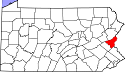 | |
| Boroughs | ||
| Townships | ||
| CDPs | ||
| Unincorporated communities | ||
| Footnotes | ‡This populated place also has portions in an adjacent county or counties | |
References
- ↑ "American FactFinder". United States Census Bureau. Archived from the original on 2013-09-11. Retrieved 2008-01-31.
 |
Jacobsburg State Park | Wind Gap | Edelman | |
| Bushkill Township | |
Kesslersville | ||
| ||||
| | ||||
| Eastlawn Gardens, Cherry Hill, Nazareth | Stockertown | Churchville, Uhlers Station |