Hanover Township, Northampton County, Pennsylvania
| Hanover Township | |
| Settlement | |
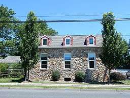 Schortz Old School House (1871) on Jacksonville Rd. | |
| Country | United States |
|---|---|
| State | Pennsylvania |
| County | Northampton |
| Elevation | 390 ft (118.9 m) |
| Coordinates | 40°41′00″N 75°22′59″W / 40.68333°N 75.38306°WCoordinates: 40°41′00″N 75°22′59″W / 40.68333°N 75.38306°W |
| Area | 6.7 sq mi (17.4 km2) |
| - land | 6.7 sq mi (17 km2) |
| - water | 0.0 sq mi (0 km2), 0% |
| Population | 10,866 (2010) |
| Density | 1,621.8/sq mi (626.2/km2) |
| Timezone | EST (UTC-5) |
| - summer (DST) | EDT (UTC-4) |
| Area code | 610 |
 Location of Hanover Township in Northampton County | |
 Location of Hanover Township in Pennsylvania | |
 Location of Pennsylvania in the United States | |
| Website: http://www.hanovertwp-nc.org | |
Hanover Township is a township in Northampton County, Pennsylvania, United States. Hanover Township is located in the Lehigh Valley region of the state.
The population of Hanover Township was 10,866 at the 2010 census.
Geography
According to the United States Census Bureau, the township has a total area of 6.7 square miles (17 km2), all of it land. It is drained by Monocacy Creek and Catasauqua Creek into the Lehigh River. Its villages include Hanoverville, Schoenersville (pronounced "SHAY-nerz-vil" and also in Lehigh County), Stoke Park, and Westgate Hills. Its numbered roads include the east-to-west Highway 22 and north-to-south Routes 512 and 987, which connect Bath with Bethlehem and Allentown as Bath Pike and Airport Road, respectively. Other local roads of note include east-to-west Hanoverville Road, Macada Road, and Stoke Park Road and north-to-south Jacksonville Road and Township Line Road. Hanover Township is a suburb of the city of Bethlehem which lies just to the north of the city. Officially has never been considered as a section of the city of Bethlehem, rather just a neighboring community with a strong connection to its large municipal neighbor to the south.
Neighboring municipalities
- East Allen Township (north)
- Lower Nazareth Township (northeast)
- Bethlehem Township (east)
- Bethlehem (southeast and southwest)
- Hanover Township, Lehigh County (west)
Demographics
As of the census[1] of 2010, there were 10,866 people, 4,245 households, and 3,144 families residing in the township. The population density was 1,634.9 people per square mile (631.0/km2). There were 4,245 housing units at an average density of 638.7/sq mi (250.0/km2). The racial makeup of the township was 87.12% White, 2.74% African American, 0.05% Native American, 6.53% Asian, 1.44% from other races, and 2.12% from two or more races. Hispanic or Latino of any race were 4.83% of the population.
There were 3,633 households, out of which 32.8% had children under the age of 18 living with them, 69.1% were married couples living together, 5.3% had a female householder with no husband present, and 23.4% were non-families. 20.3% of all households were made up of individuals, and 9.4% had someone living alone who was 65 years of age or older. The average household size was 2.59 and the average family size was 3.01.
In the township the population was spread out, with 24.7% under the age of 18, 4.5% from 18 to 24, 26.3% from 25 to 44, 27.0% from 45 to 64, and 17.8% who were 65 years of age or older. The median age was 44.5 years. For every 100 females there were 94.1 males. For every 100 females age 18 and over, there were 91.6 males.
The median income for a household in the township was $64,889, and the median income for a family was $72,661. Males had a median income of $53,158 versus $33,569 for females. The per capita income for the township was $29,370. About 2.0% of families and 2.2% of the population were below the poverty line, including 1.9% of those under age 18 and 2.9% of those age 65 or over.
Government
Hanover is represented in the Pennsylvania House of Representatives as part of the 138th Legislative District. The 138th District consists of the townships of Bethlehem (Wards 1 and 4), Bushkill, East Allen, Hanover, Lower Nazareth, Moore and Plainfield; and the boroughs of Bath, Chapman, Pen Argyl and Wind Gap. The township is represented in the Pennsylvania Senate as part of the 40th District, which includes parts of Monroe and Northampton Counties. The township is patrolled by the Colonial Regional Police Department.
On the national level, Hanover is a part of Pennsylvania’s 15th congressional district, and is currently represented by Charles W. Dent. The state's senior (Class II) member of the United States Senate, is Bob Casey, Jr. who was elected in 2006. The junior (Class I) Senator, elected in 2010, is Patrick J. Toomey. Hanover is governed by the Board of Supervisors form of government, led by a township manager and a board of supervisors.
Historical Population
| Year | Population | Year | Population | Year | Population | Year | Population | Year | Population |
|---|---|---|---|---|---|---|---|---|---|
| 1880 | 503 | 1910 | 403 | 1940 | 585 | 1970 | 5,434 | 2000 | 9,563 |
| 1890 | 440 | 1920 | 393 | 1950 | 891 | 1980 | 6,073 | 2010 | 10,866 |
| 1900 | 401 | 1930 | 526 | 1960 | 1,932 | 1990 | 7,176 | 2020 | |
Public education
The township is served by the Bethlehem Area School District. Asa Packer and Hanover elementary schools are located within the Township. The charter school Lehigh Valley Academy , which uses the International Baccalaureate academic program, is also located in the township.
Gallery
 Township Municipal Office.
 Community Center.
 Advent Moravian Church.
 Christ United Church of Christ in Schoenersville.
References
- ↑ "American FactFinder". United States Census Bureau. Retrieved 2008-01-31.
External links
| Wikimedia Commons has media related to Hanover Township, Northampton County, Pennsylvania. |
Municipalities and communities of Northampton County, Pennsylvania, United States | ||
|---|---|---|
| Cities | 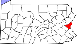 | |
| Boroughs | ||
| Townships | ||
| CDPs | ||
| Unincorporated communities | ||
| Footnotes | ‡This populated place also has portions in an adjacent county or counties | |