R. S. Puram, Coimbatore
| R. S. Puram | |
|---|---|
| Neighbourhood | |
|
Diwan Bahadur Road | |
 R. S. Puram Location in Tamil Nadu, India | |
| Coordinates: 11°12′N 77°00′E / 11.2°N 77.0°ECoordinates: 11°12′N 77°00′E / 11.2°N 77.0°E | |
| Country |
|
| State | Tamil Nadu |
| District | Coimbatore |
| Elevation | 411 m (1,348 ft) |
| Languages | |
| • Official | Tamil |
| Time zone | IST (UTC+5:30) |
| PIN | 641002 |
| Telephone code | 91-422 |
| Vehicle registration | TN-66 |

RS Puram (or "Rathina Sabapathi Puram") is a residential area and shopping district in Coimbatore in the state of Tamil Nadu, India. R.S Puram is considered a perfect mixture of commercial and residential hub. The neighborhood is abound with multi-national commercial establishments, important government offices, sprawling educational institutions, shopping complexes, sporting facilities, tourist spots, restaurants, and cultural centers. R.S Puram also a prime residential area in Coimbatore. Coimbatore is also known as manchester of south India.
Geography
RS Puram is situated in the western part of the city near Old Coimbatore area of Ukkadam and Poomarket between Mettupalayam Road and Thadagam Road. RS Puram shares a border with: Sai Baba colony, Sukrawarpettai, Gandhi Park, Mettupalayam Road, Tamil Nadu Agri University Campus(TNAU), Forest Campus and Thadagam Road.[1]
Population
RS Puram has an approximate population of 1,00,000. Almost all the new generation companies including IT and mobile companies are operating their Head Offices in RS Puram. Hence RS Puram has a large group of floating population.[2]
Climate
RS Puram possess similar climatic condition of Coimbatore City, as it is only a part of the city [3][4] highest temperature ever recorded is 41 °C and lowest is 12 °C.[5]
Economy
Many rich and posh commercial properties of the City are situated at RS Puram. As of now RS Puram is the third largest commercial hub of the Coimbatore City after Town hall and Gandhipuram, Coimbatore.[6] RS Puram has a large number of multinational chains and is one of the major shopping centres in Coimbatore.
Infrastructure
Design
RS Puram is a well planned area. DB Road is the nerve centre. All roads running east-west cross DB Road and exit to Mettupalayam Road on the east and Thadagam Road on the west.
Localities
Localities of RS Puram include
- Diwan Bahadur Road-Main road
- TV Swamy Road(Tiruvenkata Swamy Road)-Main road
- Cowley Brown Road(Lawlly road)-Main road (Cowley Brown was first Principal of Forest Campus and Lawlly was first Principal and Founder of Agricultural University)
- Ponnurangam Road
- Vekatasamy Road [West and East]
- Shanmugam Road
- Periaswamy Road
- Bashyakarlu Road
- Lokamanya Street
- Sambandam Road
- VenkataRamana Road
- Arokiyasamy Road
- Azad Road
- Ramalingam Road
- Arunachalam Street
- Robertson Road
- Siva Subramaniam Road
- Father Randy Street
Gallery
 Lotus Eye Hospital and Institute at Rs Puram
 KFC at R.S Puram
 Midtown towers on D.B Road
 Shops on D.B Road
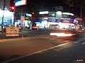 D.B Road signal
 Shops on D.B Road
 Diwan Bahadur Road
 Diwan Bahadur Road
 Foundation one apartment on TV Swamy Road
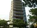 Foundation one apartment on TV Swamy Road
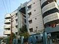 Mayflower apartments
 Father of Modern Coimbatore
References
- ↑ "Gandhipuram Borders : Map showing surrounding areas of Gandhipuram".
- ↑ "Census of India 2001: Data from the 2001 Census, including cities, villages and towns (Provisional)". Census Commission of India. Archived from the original on 2004-06-16. Retrieved 2008-11-01.
- ↑ "Temperature and Rainfall chart" (PDF). Coimbatore district collectorate. Retrieved 2009-01-17.
- ↑ "Coimbatore Corporation - SHB002" (PDF). Coimbatore Corporation. Retrieved 2009-09-23.
- ↑ "Historical Weather for Coimbatore, India". Weatherbase. Retrieved 2009-09-23.
- ↑ Coimbatore's wealth creators, The Hindu
| Wikimedia Commons has media related to R. S. Puram, Coimbatore. |
| State symbols |
|
|---|---|
| Governance |
|
| Topics | |
| Districts |
|
| Major cities | |