Pushaw Lake
| Pushaw Lake | |
|---|---|
 | |
| Location | Penobscot County, Maine, United States |
| Coordinates | 44°55′59″N 68°48′04″W / 44.933027°N 68.801013°WCoordinates: 44°55′59″N 68°48′04″W / 44.933027°N 68.801013°W[1] |
| Type | Glacial |
| Primary inflows | Pushaw Stream and others |
| Primary outflows | Pushaw Stream to Penobscot River |
| Basin countries | United States |
| Max. length | 7.6 mi (12.2 km) |
| Max. width | 2.3 mi (3.7 km) |
| Surface area | 4,680 acres (1,890 ha) |
| Average depth | 11 ft (3.4 m) |
| Max. depth | 28 ft (8.5 m) |
| Water volume | 53,102 acre foot (65,500,000 m3) |
| Surface elevation | 115 ft (35 m) |
| Islands | 14+ |
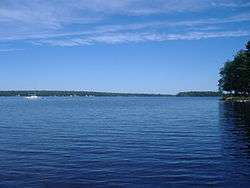
Pushaw Lake is a lake in Penobscot County, Maine, United States about 6.5 miles (10.5 km) north of downtown Bangor and 4.5 mi (7.2 km) west of downtown Orono. The lake is part of the towns of Orono, Old Town, Hudson, and Glenburn. There are roads and private residences along much of the lake, except the southeastern side where the Caribou Bog complex borders the lake. A small dam was constructed in 1920 at the lake's outflow to maintain constant water levels.[2][3][4]
References
- ↑ "Pushaw Lake". Geographic Names Information System. United States Geological Survey. Retrieved December 18, 2012.
- ↑ Pushaw Lake, ME (Map). USGS.
- ↑ "Pushaw Lake" (PDF). Maine Department of Inland Game and Fisheries. Retrieved December 18, 2012.
- ↑ "Pushaw Lake". Maine Fish Finder. Retrieved December 18, 2012.
This article is issued from Wikipedia - version of the 6/2/2016. The text is available under the Creative Commons Attribution/Share Alike but additional terms may apply for the media files.