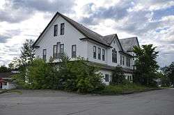
Island Falls, Maine
| Island Falls, Maine | |
|---|---|
| Town | |
|
| |
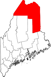
 Location of Island Falls, Maine | |
| Coordinates: 46°0′31″N 68°15′53″W / 46.00861°N 68.26472°W | |
| Country | United States |
| State | Maine |
| County | Aroostook |
| Area[1] | |
| • Total | 40.76 sq mi (105.57 km2) |
| • Land | 36.03 sq mi (93.32 km2) |
| • Water | 4.73 sq mi (12.25 km2) |
| Elevation | 443 ft (135 m) |
| Population (2010)[2] | |
| • Total | 837 |
| • Estimate (2012[3]) | 828 |
| • Density | 23.2/sq mi (9.0/km2) |
| Time zone | Eastern (EST) (UTC-5) |
| • Summer (DST) | EDT (UTC-4) |
| ZIP code | 04747 |
| Area code(s) | 207 |
| FIPS code | 23-35065 |
| GNIS feature ID | 0582529 |
Island Falls is a town in Aroostook County, Maine, United States. The population was 837 at the 2010 census. Island Falls took its name from an island in the stream at the verge of a waterfall.[4]
Geography
According to the United States Census Bureau, the town has a total area of 40.76 square miles (105.57 km2), of which 36.03 square miles (93.32 km2) is land and 4.73 square miles (12.25 km2) is water.[1] Island Falls also has two main lakes, Pleasant and Mattawamkeag.
Demographics
| Historical population | |||
|---|---|---|---|
| Census | Pop. | %± | |
| 1870 | 183 | — | |
| 1880 | 236 | 29.0% | |
| 1890 | 223 | −5.5% | |
| 1900 | 1,063 | 376.7% | |
| 1910 | 1,686 | 58.6% | |
| 1920 | 1,683 | −0.2% | |
| 1930 | 1,455 | −13.5% | |
| 1940 | 1,370 | −5.8% | |
| 1950 | 1,237 | −9.7% | |
| 1960 | 1,018 | −17.7% | |
| 1970 | 913 | −10.3% | |
| 1980 | 981 | 7.4% | |
| 1990 | 897 | −8.6% | |
| 2000 | 793 | −11.6% | |
| 2010 | 837 | 5.5% | |
| Est. 2014 | 814 | [5] | −2.7% |
2010 census
As of the census[2] of 2010, there were 837 people, 357 households, and 228 families residing in the town. The population density was 23.2 inhabitants per square mile (9.0/km2). There were 655 housing units at an average density of 18.2 per square mile (7.0/km2). The racial makeup of the town was 97.4% White, 0.4% African American, 0.8% Native American, 0.1% Asian, 0.2% from other races, and 1.1% from two or more races. Hispanic or Latino of any race were 2.0% of the population.
There were 357 households of which 25.8% had children under the age of 18 living with them, 49.0% were married couples living together, 11.5% had a female householder with no husband present, 3.4% had a male householder with no wife present, and 36.1% were non-families. 31.9% of all households were made up of individuals and 19.3% had someone living alone who was 65 years of age or older. The average household size was 2.31 and the average family size was 2.88.
The median age in the town was 46.4 years. 21.5% of residents were under the age of 18; 6.2% were between the ages of 18 and 24; 20.7% were from 25 to 44; 31.5% were from 45 to 64; and 20% were 65 years of age or older. The gender makeup of the town was 49.6% male and 50.4% female.
2000 census
At the 2000 census,[7] there were 793 people, 346 households and 229 families residing in the town. The population density was 22.1 per square mile (8.5/km²). There were 635 housing units at an average density of 17.7 per square mile (6.8/km²). The racial makeup of the town was 99.12% White, 0.76% Native American and 0.13% Asian. Hispanic or Latino of any race were 0.88% of the population.
There were 346 households of which 26.9% had children under the age of 18 living with them, 55.2% were married couples living together, 8.7% had a female householder with no husband present, and 33.8% were non-families. 28.6% of all households were made up of individuals and 14.2% had someone living alone who was 65 years of age or older. The average household size was 2.29 and the average family size was 2.81.
21.1% of the population was under the age of 18, 8.6% from 18 to 24, 24.1% from 25 to 44, 28.1% from 45 to 64, and 18.2% who were 65 years of age or older. The median age was 43 years. For every 100 females there were 90.6 males. For every 100 females age 18 and over, there were 92.0 males.
The median household income was $27,083, and the median family income was $35,375. Males had a median income of $32,019 versus $19,028 for females. The per capita income for the town was $15,132. About 10.5% of families and 14.2% of the population were below the poverty line, including 19.1% of those under age 18 and 11.6% of those age 65 or over.
Places of interest
References
- 1 2 "US Gazetteer files 2010". United States Census Bureau. Retrieved 2012-12-16.
- 1 2 "American FactFinder". United States Census Bureau. Retrieved 2012-12-16.
- ↑ "Population Estimates". United States Census Bureau. Retrieved 2013-07-06.
- ↑ Gannett, Henry (1905). The Origin of Certain Place Names in the United States. Govt. Print. Off. p. 166.
- ↑ "Annual Estimates of the Resident Population for Incorporated Places: April 1, 2010 to July 1, 2014". Retrieved June 4, 2015.
- ↑ "Census of Population and Housing". Census.gov. Retrieved June 4, 2015.
- ↑ "American FactFinder". United States Census Bureau. Retrieved 2008-01-31.
External links
- Varney, George J. (1886), Gazetteer of the state of Maine. Island Falls, Boston: Russell
- Photograph of Main Street, Island Falls, ca. 1910 from the Maine Memory Network
Coordinates: 46°00′33″N 68°16′17″W / 46.00917°N 68.27139°W