Picacho, Arizona
| Picacho, Arizona | |
|---|---|
| Census-designated place | |
|
Picacho post office | |
 Location in Pinal County and the state of Arizona | |
 Picacho, Arizona Location in the United States | |
| Coordinates: 32°42′58″N 111°29′43″W / 32.71611°N 111.49528°WCoordinates: 32°42′58″N 111°29′43″W / 32.71611°N 111.49528°W | |
| Country | United States |
| State | Arizona |
| County | Pinal |
| Elevation | 1,614 ft (492 m) |
| Population (2000) | |
| • Total | 521 |
| Time zone | Mountain (MST) (UTC-7) |
| ZIP code | 85241 |
| Area code(s) | 520 |
| GNIS feature ID | 9393[1] |

Picacho is an unincorporated community and census-designated place in Pinal County, Arizona, United States. The population was 471 at the 2010 census.
Picacho is located near Interstate 10 4.5 miles (7.2 km) southeast of Eloy and 7 miles (11 km) northwest of Picacho Peak State Park. Picacho has a post office with ZIP code 85241, which opened in 1881.[2] The community's name is Spanish for "peak" and is derived from the Picacho Mountains.[1] Picacho has a ZIP Code of 85241; in 2000, the population of the 85241 ZCTA was 521.[3]
By late 2012 parts of Picacho will be removed under Arizona eminent domain law on account of Interstate 10 expansion.
Demographics
In 2010 Picacho had a population of 471. The racial and ethnic makeup of the population was 62.4% Hispanic or Latino, 33.8% non-Hispanic white, 0.6% non-Hispanic black, 0.7% Hispanic blacks, 1.5% non-Hispanic Native American, 1.0% Hispanic Native Americans, 0.6% non-Hispanics reporting some other race and 7.0% of the population reporting two or more races.[4]
References

Municipalities and communities of Pinal County, Arizona, United States | ||
|---|---|---|
| Cities | 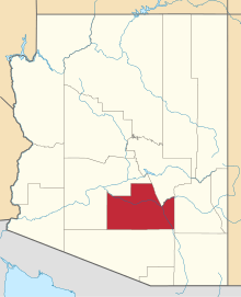 | |
| Towns | ||
| CDPs |
| |
| Unincorporated communities | ||
| Indian reservations | ||
| Ghost towns | ||
| Footnotes | ‡This populated place also has portions in an adjacent county or counties | |