Queen Creek, Arizona
| Queen Creek, Arizona | ||
|---|---|---|
| Town | ||
|
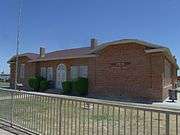
Queen Creek Town Hall | ||
| ||
 Location in Maricopa County and the state of Arizona | ||
 Queen Creek, Arizona Location in the United States | ||
| Coordinates: 33°15′47″N 111°38′05″W / 33.26306°N 111.63472°WCoordinates: 33°15′47″N 111°38′05″W / 33.26306°N 111.63472°W | ||
| Country | United States | |
| State | Arizona | |
| Counties | Maricopa, Pinal | |
| Incorporated | 1989 | |
| Government | ||
| • Mayor | Gail Barney | |
| Area | ||
| • Total | 28.5 sq mi (73.8 km2) | |
| • Land | 28.5 sq mi (73.8 km2) | |
| • Water | 0 sq mi (0 km2) | |
| Elevation | 1,404 ft (428 m) | |
| Population (2010)[1] | ||
| • Total | 26,361 | |
| • Estimate (2014)[2] | 32,236 | |
| • Density | 644.5/sq mi (248.9/km2) | |
| Time zone | MST (no DST) (UTC-7) | |
| ZIP codes | 85142 | |
| Area code(s) | 480 | |
| FIPS code | 04-58150 | |
| Website | http://www.queencreek.org/ | |


Queen Creek is a town in Maricopa and Pinal counties in the state of Arizona. The population was 26,361 at the 2010 census.[1] As of July 2016, Queen Creek's population is estimated to be 33,649.[3]
Geography
Queen Creek is located at 33°15′47″N 111°38′05″W / 33.26306°N 111.63472°W (33.263101, -111.634685).[4] The Town of Queen Creek is primarily within Maricopa County, but the Town Limits also extend into Pinal County on the eastern and southern borders. Even further to the east and south of QC Town Limits in Pinal County is the large (est. 87,000 population in 2015) unincorporated community of San Tan Valley.
According to the United States Census Bureau, the town has a total area of 25.8 square miles (66.8 km²), all of it land.
Demographics
| Historical population | |||
|---|---|---|---|
| Census | Pop. | %± | |
| 1980 | 1,378 | — | |
| 1990 | 2,667 | 93.5% | |
| 2000 | 4,316 | 61.8% | |
| 2010 | 26,361 | 510.8% | |
| Est. 2015 | 34,614 | [5] | 31.3% |
| U.S. Decennial Census[6] 2014 Estimate[2] | |||
As of the census of 2010, there were 26,361 people, 8,557 households, residing in the town. The population density was 167.3 people per square mile (64.6/km²). There were 8,557 housing units at an average density of 49.6 per square mile (19.2/km²). The racial makeup of the town was 82.14% White, 0.35% Black or African American, 6.53% Native American, 0.32% Asian, 0.07% Pacific Islander, 14.30% from other races, and 2.29% from two or more races. 17.3% of the population were Hispanic or Latino of any race.
There were 1,218 households out of which 50.7% had children under the age of 18 living with them, 75.9% were married couples living together, 7.2% had a female householder with no husband present, and 11.8% were non-families. 8.0% of all households were made up of individuals and 2.8% had someone living alone who was 65 years of age or older. The average household size was 3.54 and the average family size was 3.77.
In the town the population age spread was: 35.4% under the age of 18, 8.7% from 18 to 24, 30.1% from 25 to 44, 20.9% from 45 to 64, and 4.8% who were 65 years of age or older. The median age was 31 years. For every 100 females there were 104.8 males. For every 100 females age 18 and over, there were 105.3 males.
The median income for a household in the town was $63,702, and the median income for a family was $65,679. Males had a median income of $45,000 versus $31,447 for females. The per capita income for the town was $21,592. About 6.0% of families and 9.2% of the population were below the poverty line, including 10.0% of those under age 18 and 6.5% of those age 65 or over.
Educational facilities
The Town of Queen Creek is served by six public school districts as well as public charter schools and a private school. Queen Creek Unified School District serves the greatest number of Queen Creek students.
The other public district schools serving QC students are Higley Unified School District, Chandler Unified School District, J.O. Combs Unified School District, and the Coolidge Unified School District
Public charter schools serving QC students include... American Leadership Academy is a local public charter district with a K-6 school and 7-12 high school located on the same campus at the southwest corner of Hawes Road and Chandler Heights Blvd.
- American Leadership Academy High School
Benjamin Franklin Charter School, Cambridge Academy, Heritage Academy are additional public charter schools educating students who live in Town of Queen Creek.
Higher Education offerings include Communiversity at Queen Creek (Rio Salado College).[7]
Cultural attractions
- The American Heritage Festival - Since 2003 the largest annual educational living history event in AZ and the Southwestern US. (http://www.americanheritagefestival.com/).[]
- Schnepf Farms - a family operated farm that holds frequent festivals (http://www.schnepffarms.com/).[]
- The Queen Creek Performing Arts Center (http://www.qcpac.com/)[]
- Horseshoe Park & Equestrian Centre - a large, publicly owned and operated equestrian facility that hosts regional events (http://www.queencreek.org/hpec).
- Queen Creek Library - the newest branch of the Maricopa County Library District that opened November 8, 2008 (http://www.queencreek.org/Index.aspx?page=712).
- Barney Family Sports Complex - a privately owned and operated indoor sports facility. (http://www.thebfsc.com/).[]
- Queen Creek Olive Mill - a family owned company that grows and presses olives for the production of high quality extra virgin. It was featured on the Food Network show The Best Thing I Ever Ate. olive oil (http://www.queencreekolivemill.com/).[]
- Rittenhouse Elementary School/San Tan Historical Society Museum
Forbes Magazine- Queen Creek, Arizona – recently named one of Forbes’ most friendly towns in the U.S.
Historic properties in Queen Creek
There are various properties in the town of Queen Creek which are considered historical and have been included either in the National Register of Historic Places[8] or listed as such by the San Tan Historical Society. The following are images of some of these properties with a short description of the same.
| Historical Structures in Queen Creek, Arizona (NRHP = National Register of Historic Places) (STHS = San Tan Historical Society.) | ||||||||||||||||||
|---|---|---|---|---|---|---|---|---|---|---|---|---|---|---|---|---|---|---|
|


References
- 1 2 "American FactFinder". United States Census Bureau. Retrieved 2014-07-10.
- 1 2 "Population Estimates". United States Census Bureau. Retrieved July 11, 2015.
- ↑ "Largest US Cities By Population". Retrieved 2016-07-11.
- ↑ "US Gazetteer files: 2010, 2000, and 1990". United States Census Bureau. 2011-02-12. Retrieved 2011-04-23.
- ↑ "Annual Estimates of the Resident Population for Incorporated Places: April 1, 2010 to July 1, 2015". Retrieved July 2, 2016.
- ↑ United States Census Bureau. "Census of Population and Housing". Archived from the original on May 11, 2015. Retrieved July 10, 2014.
- ↑ "Communiversity at Queen Creek". riosalado.edu. Retrieved 28 January 2016.
- ↑ "National Register of Historical Places - ARIZONA (AZ), Maricopa County". National Register of Historic Places. Retrieved 28 January 2016.
External links
- Queen Creek movers
- Queen Creek town limits
- Queen Creek Named NerdWallet's 2nd City on the Rise in Arizona
Municipalities and communities of Maricopa County, Arizona, United States | ||
|---|---|---|
| Cities | 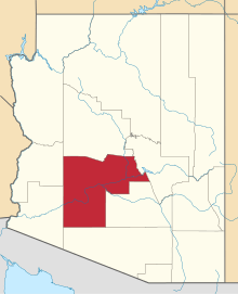 | |
| Towns | ||
| CDPs | ||
| Unincorporated communities |
| |
| Indian reservations | ||
| Ghost towns | ||
| Footnotes | ‡This populated place also has portions in an adjacent county or counties | |