Peabody Township, Marion County, Kansas
| Peabody Township Marion County, Kansas | |
|---|---|
| Township | |
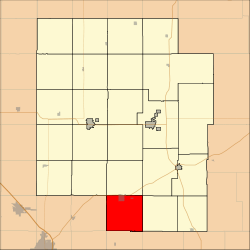 Location within Marion County | |
 Peabody Township Marion County, Kansas Location within the state of Kansas | |
| Coordinates: 38°9′40″N 097°6′22″W / 38.16111°N 97.10611°WCoordinates: 38°9′40″N 097°6′22″W / 38.16111°N 97.10611°W | |
| Country | United States |
| State | Kansas |
| County | Marion |
| Area | |
| • Total | 36 sq mi (90 km2) |
| Dimensions | |
| • Length | 6.0 mi (9.7 km) |
| • Width | 6.0 mi (9.7 km) |
| Elevation | 1,434 ft (437 m) |
| Population (2010)[1] | |
| • Total | 1,382 |
| • Density | 38/sq mi (15/km2) |
| Time zone | CST (UTC-06:00) |
| • Summer (DST) | CDT (UTC-05:00) |
| Area code(s) | 620 |
| FIPS code | 20-55125 [2] |
| GNIS feature ID | 477777 [3] |
| Website | County Website |
|
| |
Peabody Township is a township in Marion County, Kansas, United States. As of the 2010 census, the township population was 1,382, including most of the city of Peabody.[1]
Geography
Peabody Township covers an area of 36 square miles (93.2 km2).
Cities and towns
The township contains the following settlements:
- City of Peabody (south of 9th Street). A small north part of Peabody is located in Catlin Township.
Cemeteries
The township contains the following cemeteries:
- No cemeteries. The Prairie Lawn Cemetery for the city of Peabody is located in Catlin Township.
Transportation
Two railroads, BNSF Railway and Union Pacific Railroad, pass through the township. The BNSF Railway runs northeast to southwest through the township.[4] The Oklahoma Kansas Texas (OKT)[5] line of the Union Pacific Railroad runs north to south through the township.[6]
U.S. Route 50 passes along the northern township edge, and follows roughly parallel to the BNSF Railway.[7]
Further reading
References
- 1 2 "2010 Total Population - Township of Peabody". U.S. Census Bureau. Retrieved June 17, 2013.
- ↑ "American FactFinder". United States Census Bureau. Retrieved 2011-05-14.
- ↑ U.S. Geological Survey Geographic Names Information System: Township of Peabody
- ↑ BNSF Railway Map.
- ↑ "UP Railroad Common Line Names" (PDF). Union Pacific Railroad. Retrieved 2013-06-15.
- ↑ Union Pacific Railway Map.
- ↑ Marion County Highway Map; KSDOT.
External links
- Marion County Website
- City-Data.com
- Marion County Maps: Current, Historic, KDOT

Municipalities and communities of Marion County, Kansas, United States | ||
|---|---|---|
| Cities | 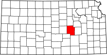 | |
| Unincorporated communities | ||
| Ghost towns | ||
| Townships | ||
| Footnotes | ‡This populated place also has portions in an adjacent county or counties | |
This article is issued from Wikipedia - version of the 7/30/2014. The text is available under the Creative Commons Attribution/Share Alike but additional terms may apply for the media files.