Durham, Kansas
| Durham, Kansas | |
|---|---|
| City | |
|
Downtown Durham (2010) | |
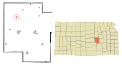 Location within Marion County and Kansas | |
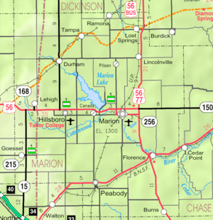 KDOT map of Marion County (legend) | |
| Coordinates: 38°29′4″N 97°13′38″W / 38.48444°N 97.22722°WCoordinates: 38°29′4″N 97°13′38″W / 38.48444°N 97.22722°W[1] | |
| Country | United States |
| State | Kansas |
| County | Marion |
| Platted |
1887 (Durham) 1887 (Funk) |
| Incorporated | 1906 |
| Government | |
| • Type | Mayor–Council |
| • Mayor | Michael Sorensen[2] |
| • City Clerk | Carla Hein [2] |
| Area[3] | |
| • Total | 0.20 sq mi (0.52 km2) |
| • Land | 0.20 sq mi (0.52 km2) |
| • Water | 0 sq mi (0 km2) |
| Elevation[1] | 1,371 ft (418 m) |
| Population (2010)[4] | |
| • Total | 112 |
| • Estimate (2015)[5] | 107 |
| • Density | 560/sq mi (220/km2) |
| Time zone | CST (UTC-6) |
| • Summer (DST) | CDT (UTC-5) |
| ZIP code | 67438 |
| Area code | 620 |
| FIPS code | 20-19050 [1] |
| GNIS feature ID | 0477238 [1] |
|
| |

Durham is a city in Marion County, Kansas, United States.[1] As of the 2010 census, the city population was 112.[6] The city took its name from Durham cattle.[7] Durham is home of Donahue Corporation.[8]
History

Early history
For many millennia, the Great Plains of North America was inhabited by nomadic Native Americans. From the 16th century to 18th century, the Kingdom of France claimed ownership of large parts of North America. In 1762, after the French and Indian War, France secretly ceded New France to Spain, per the Treaty of Fontainebleau.
19th century
In 1802, Spain returned most of the land to France. In 1803, most of the land for modern day Kansas was acquired by the United States from France as part of the 828,000 square mile Louisiana Purchase for 2.83 cents per acre.
In 1806, Zebulon Pike led the Pike expedition westward from St Louis, Missouri, of which part of their journey followed the Cottonwood River through Marion County near the current cities of Florence, Marion, Durham.[9]
From the 1820s to the 1870s, one of the most significant land routes in the United States was the Santa Fe Trail. It was located about 1 mile northwest of Durham. The trail was active across Marion County from 1821 to 1866.[10]
In 1854, the Kansas Territory was organized, then in 1861 Kansas became the 34th U.S. state. In 1855, Marion County was established within the Kansas Territory, which included the land for modern day Durham.[11]
In 1887, the Chicago, Kansas and Nebraska Railway built a main line from Herington through Durham to Pratt.[12] In 1888, this line was extended to Liberal. Later, it was extended to Tucumcari, New Mexico and El Paso, Texas. It foreclosed in 1891 and taken over by Chicago, Rock Island and Pacific Railway, which shut down in 1980 and reorganized as Oklahoma, Kansas and Texas Railroad, merged in 1988 with Missouri Pacific Railroad, and finally merged in 1997 with Union Pacific Railroad. Most locals still refer to this railroad as the "Rock Island".
A post office was established in Durham Park on June 22, 1874 (near current Cottonwood Grove Christian School northwest of Durham), then it was moved to the community of Durham on September 19, 1887[13] around the time the new railroad was built through the area.
20th century
In 1906, Durham incorporated as a city.[14]
In 1962, James C. Donahue established the Donahue Corporation, maker of farm implement carriers, and has grown to a 40,000 sq ft (3,700 m2) facility. They have built and distributed over 50,000 implement carriers.[8] It currently is located approximately 0.5 mile northeast of Durham on 290th St.
Geography
Durham is located at 38°29′04″N 97°13′38″W / 38.484392°N 97.227337°W (38.484392, -97.227337).[1] According to the United States Census Bureau, the city has a total area of 0.20 square miles (0.52 km2), all of it land.[3]
Climate
The climate in this area is characterized by hot, humid summers and generally mild to cool winters. According to the Köppen Climate Classification system, Durham has a humid subtropical climate, abbreviated "Cfa" on climate maps.[15]
Area attractions
Durham has one listing on the National Register of Historic Places (NRHP).
- Santa Fe Trail:
- Santa Fe Trail - Marion County Segments[16] (NRHP), 2.5 miles (4.0 km) south-west of Durham. From corner of 270th St and Falcon Rd, parallels on west side of railroad tracks towards southwest. The ruts are approximate 3 miles (4.8 km) long, and described by the National Park Service as "outstanding". Not open to public.
- Santa Fe Trail Cottonwood Crossing Kiosk, 1 west at 290th St.[17]
- Santa Fe Trail Cottonwood Crossing Marker, north-west of Durham.
- Santa Fe Trail Markers, numerous markers in the area.
- Santa Fe Trail Self-Guided Auto Tour.
- Marion Reservoir, south-east of Durham.
Demographics
| Historical population | |||
|---|---|---|---|
| Census | Pop. | %± | |
| 1910 | 268 | — | |
| 1920 | 288 | 7.5% | |
| 1930 | 254 | −11.8% | |
| 1940 | 245 | −3.5% | |
| 1950 | 229 | −6.5% | |
| 1960 | 183 | −20.1% | |
| 1970 | 143 | −21.9% | |
| 1980 | 130 | −9.1% | |
| 1990 | 119 | −8.5% | |
| 2000 | 114 | −4.2% | |
| 2010 | 112 | −1.8% | |
| Est. 2015 | 107 | [5] | −4.5% |
| U.S. Decennial Census | |||
2010 census
As of the census[4] of 2010, there were 112 people, 48 households, and 34 families residing in the city. The population density was 560.0 inhabitants per square mile (216.2/km2). There were 65 housing units at an average density of 325.0 per square mile (125.5/km2). The racial makeup of the city was 99.1% White and 0.9% from other races. Hispanic or Latino of any race were 4.5% of the population.
There were 48 households of which 25.0% had children under the age of 18 living with them, 66.7% were married couples living together, 4.2% had a female householder with no husband present, and 29.2% were non-families. 25.0% of all households were made up of individuals and 12.5% had someone living alone who was 65 years of age or older. The average household size was 2.33 and the average family size was 2.79.
The median age in the city was 47 years. 20.5% of residents were under the age of 18; 5.5% were between the ages of 18 and 24; 22.4% were from 25 to 44; 27.7% were from 45 to 64; and 24.1% were 65 years of age or older. The gender makeup of the city was 51.8% male and 48.2% female.
2000 census
As of the census of 2000,[18] there were 114 people, 51 households, and 29 families residing in the city. The population density was 541.7 people per square mile (209.6/km2). There were 64 housing units at an average density of 304.1 per square mile (117.7/km2). The racial makeup of the city was 98.25% White and 1.75% from two or more races. Hispanic or Latino of any race were 0.88% of the population.
There were 51 households out of which 27.5% had children under the age of 18 living with them, 45.1% were married couples living together, 9.8% had a female householder with no husband present, and 41.2% were non-families. 37.3% of all households were made up of individuals and 25.5% had someone living alone who is 65 years of age or older. The average household size was 2.24 and the average family size was 2.87.
In the city the population was spread out with 23.7% under the age of 18, 6.1% from 18 to 24, 19.3% from 25 to 44, 29.8% from 45 to 64, and 21.1% who were 65 years of age or older. The median age was 46 years. For every 100 females there were 100.0 males. For every 100 females age 18 and over, there were 77.6 males.
As of 2000 the median income for a household in the city was $26,875, and the median income for a family was $47,917. Males had a median income of $28,000 versus $25,625 for females. The per capita income for the city was $16,402. No families and 3.1% of the population were below the poverty line, including none under the age of 18 and over age 65.
Economy
Durham is home of Donahue Corporation.[8]
Government
The Durham government consists of a mayor and five council members. The council meets the 1st Tuesday after the 1st Monday of each month at 7PM.[2]
- Fire Department, Douglas Ave.
- Durham Community Center, Douglas Ave.
- U.S. Post Office, 508 S Douglas Ave.
Education
Primary and secondary education
Durham is part of Unified School District 410.[19][20] The high school is a member of T.E.E.N., a shared video teaching network between five area high schools.[21] All students attend schools in Hillsboro.
- Hillsboro High School, located in Hillsboro.
- Hillsboro Middle School, located in Hillsboro.
- Hillsboro Elementary School, located in Hillsboro.
Private Schools
- Cottonwood Grove Christian School, Private Grade School, 2925 Goldenrod Rd, approximately 1 mile northwest of Durham.
Infrastructure
Transportation
K-15 highway runs along the east side of the city. Durham is served by the Union Pacific Railroad, formerly the Southern Pacific, and prior, the Chicago, Rock Island and Pacific Railroad. Durham is located on UP's Golden State main line to El Paso, Texas. A Union Pacific Local still serves the Durham Elevator during the Kansas summer harvests. The line was originally built by the Chicago, Kansas and Nebraska Railroad.
Utilities
- Internet
- Wireless is provided by Pixius Communications.
- Satellite is provided by HughesNet, StarBand, WildBlue.
- TV
- Satellite is provided by DirecTV, Dish Network.
- Terrestrial is provided by regional digital TV stations.
- Electricity
- Rural is provided by Flint Hills RECA.
- Water
- City is provided by City of Durham.
- Rural is provided by Marion County RWD #1 and #4.
See also
- Durham Park Township, Marion County, Kansas (location of Durham)
- National Register of Historic Places listings in Marion County, Kansas
- Historical Maps of Marion County, Kansas
Further reading
- Durham
- Durham Kansas Centennial 1887-1987 Pride in the Past Faith in the Future; B002FD0F7E; 222 pages; 1987.
- Santa Fe Trail
- Marion County Auto Tour of the Santa Fe Trail; 2 pages. (Download 1MB PDF Flyer)
- The Story of the Marking of the Santa Fe Trail by the Daughters of the American Revolution in Kansas and the State of Kansas; Almira Cordry; Crane Co; 164 pages; 1915. (Download 4MB PDF eBook)
References
- 1 2 3 4 5 6 Geographic Names Information System (GNIS) details for Durham, Kansas; United States Geological Survey (USGS); October 13, 1978.
- 1 2 3 Durham - Directory of Public Officials
- 1 2 "US Gazetteer files 2010". United States Census Bureau. Retrieved 2012-07-06.
- 1 2 "American FactFinder". United States Census Bureau. Retrieved 2012-07-06.
- 1 2 "Annual Estimates of the Resident Population for Incorporated Places: April 1, 2010 to July 1, 2015". Retrieved July 2, 2016.
- ↑ "2010 City Population and Housing Occupancy Status". U.S. Census Bureau. Retrieved March 6, 2011.
- ↑ "Profile for Durham, Kansas". ePodunk. Retrieved 6 July 2014.
- 1 2 3 Donahue Corporation
- ↑ 1806 Pike Expedition map through Marion County.
- ↑ History of the Cottonwood Crossing Chapter, Santa Fe Trail Association.
- ↑ The History of Marion County and Courthouse
- ↑ Rock Island Rail History
- ↑ "Kansas Post Offices, 1828-1961 (archived)". Kansas Historical Society. Archived from the original on October 9, 2013. Retrieved 14 June 2014.
- ↑ Blackmar, Frank Wilson (1912). Kansas: A Cyclopedia of State History, Embracing Events, Institutions, Industries, Counties, Cities, Towns, Prominent Persons, Etc. Standard Publishing Company. p. 554.
- ↑ Climate Summary for Durham, Kansas
- ↑ National Register of Historic Places - Santa Fe Trail - Marion County Segments
- ↑ Cottonwood Crossing
- ↑ "American FactFinder". United States Census Bureau. Retrieved 2008-01-31.
- ↑ USD 410
- ↑ Kansas School District Boundary Map
- ↑ T.E.E.N. video teaching network
External links
| Wikimedia Commons has media related to Durham, Kansas. |
- City
- City of Durham, archive of former website
- Durham - Directory of Public Officials
- Schools
- USD 410, school district for Hillsboro, Lehigh, Durham, nearby rural areas of Marion County
- USD 410 School District Boundary Map, KDOT
- Historical
- Historic Images of Durham, Special Photo Collections at Wichita State University Library.
- Marion County cemetery list, archive of KsGenWeb
- Marion County history bibliography, Marion County school bibliography, Kansas Historical Society
- Maps
- Durham City Map, KDOT
- Topo Map of Durham / Hillsboro area, USGS
- Santa Fe Trail map, NPS
- Marion County Maps: Current, Historic, KDOT
Municipalities and communities of Marion County, Kansas, United States | ||
|---|---|---|
| Cities | 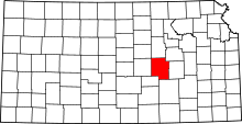 | |
| Unincorporated communities | ||
| Ghost towns | ||
| Townships | ||
| Footnotes | ‡This populated place also has portions in an adjacent county or counties | |