Eastshore, Kansas
| Eastshore, Kansas | |
|---|---|
| Unincorporated community | |
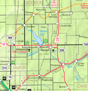 KDOT map of Marion County (legend) | |
 Eastshore  Eastshore | |
| Coordinates: 38°22′55″N 097°04′26″W / 38.38194°N 97.07389°WCoordinates: 38°22′55″N 097°04′26″W / 38.38194°N 97.07389°W[1] | |
| Country | United States |
| State | Kansas |
| County | Marion |
| Township | Gale |
| Platted | 1969 |
| Elevation[1] | 1,381 ft (421 m) |
| Time zone | CST (UTC-6) |
| • Summer (DST) | CDT (UTC-5) |
| Area code | 620 |
| FIPS code | 20-19700 [1] |
| GNIS feature ID | 0484811 [1] |
|
| |
Eastshore is an unincorporated community in Marion County, Kansas, United States.[1] The community name comes from it being near the east shore of the Marion Reservoir.
History
Early history
For many millennia, the Great Plains of North America was inhabited by nomadic Native Americans. From the 16th century to 18th century, the Kingdom of France claimed ownership of large parts of North America. In 1762, after the French and Indian War, France secretly ceded New France to Spain, per the Treaty of Fontainebleau.
19th century
In 1802, Spain returned most of the land to France. In 1803, most of the land for modern day Kansas was acquired by the United States from France as part of the 828,000 square mile Louisiana Purchase for 2.83 cents per acre.
In 1806, Zebulon Pike led the Pike expedition westward from St Louis, Missouri, of which part of their journey followed the Cottonwood River through Marion County near the current cities of Florence, Marion, Durham, and the community of Eastshore.[2]
In 1854, the Kansas Territory was organized, then in 1861 Kansas became the 34th U.S. state. In 1855, Marion County was established within the Kansas Territory, which included the land for modern day Eastshore.[3]
20th century
From 1964 to 1968, the Marion Reservoir was constructed. Eastshore was platted on October 13, 1969.[4]
Geography
Eastshore is located at 38°22′55″N 97°4′26″W / 38.38194°N 97.07389°W (38.3819584, -97.0739122),[1] and lies immediately east of the Marion Cove of the Marion Reservoir.[5][6]
Climate
The climate in this area is characterized by hot, humid summers and generally mild to cool winters. According to the Köppen Climate Classification system, Eastshore has a humid subtropical climate, abbreviated "Cfa" on climate maps.[7]
Area attractions
- Marion Reservoir, immediately west of Eastshore. The Marion cove is immediately west of Eastshore. The Cottonwood Point cove is about 0.5 miles northwest of Eastshore. The Dam is 0.1 miles southwest of Eastshore. There are additional coves on the west side of the Reservoir.
Education
Primary and secondary education
Eastshore is part of Unified School District 408.[8][9] The high school is a member of T.E.E.N., a shared video teaching network between five area high schools.[10] All students attend schools in Marion.
- Marion High School, located in Marion.
- Marion Middle School, located in Marion.
- Marion Elementary School, located in Marion.
Infrastructure
Transportation
U.S. Route 56 runs 1.33 miles (2.14 km) south of the community.
Utilities
- Internet
- Wireless is provided by Pixius Communications.
- Satellite is provided by HughesNet, StarBand, WildBlue.
- TV
- Satellite is provided by DirecTV, Dish Network.
- Terrestrial is provided by regional digital TV stations.
- Electricity
- Community and Rural areas provided by Flint Hills RECA.
- Water
- Community and Rural areas provided by Marion County RWD #2.
See also
- Gale Township, Marion County, Kansas (location of Eastshore)
- Historical Maps of Marion County, Kansas
Further reading
References
- 1 2 3 4 5 6 Geographic Names Information System (GNIS) details for Eastshore, Kansas; United States Geological Survey (USGS); October 13, 1978.
- ↑ 1806 Pike Expedition map through Marion County.
- ↑ The History of Marion County and Courthouse
- ↑ Marion County Kansas, Past and Present; Sondra Van Meter; 1972.
- ↑ Map of Marion Reservoir
- ↑ Eastshore gets zoning district
- ↑ Climate Summary for Eastshore, Kansas
- ↑ USD 408
- ↑ Kansas School District Boundary Map
- ↑ T.E.E.N. video teaching network
External links
| Wikimedia Commons has media related to Eastshore, Kansas. |
- Schools
- USD 408, school district for Marion, Florence, Eastshore, Canada, Aulne, nearby rural areas of Marion County
- USD 408 School District Boundary Map, KDOT
- Historical
- Marion County cemetery list, archive of KsGenWeb
- Marion County history bibliography, Marion County school bibliography, Kansas Historical Society
- Maps
- Marion County Maps: Current, Historic, KDOT
- Topo Map of Eastshore and Pilsen area, USGS
Municipalities and communities of Marion County, Kansas, United States | ||
|---|---|---|
| Cities | 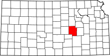 | |
| Unincorporated communities | ||
| Ghost towns | ||
| Townships | ||
| Footnotes | ‡This populated place also has portions in an adjacent county or counties | |