Gale Township, Marion County, Kansas
| Gale Township Marion County, Kansas | |
|---|---|
| Township | |
 Location within Marion County | |
 Gale Township Marion County, Kansas Location within the state of Kansas | |
| Coordinates: 38°23′15″N 097°5′21″W / 38.38750°N 97.08917°WCoordinates: 38°23′15″N 097°5′21″W / 38.38750°N 97.08917°W | |
| Country | United States |
| State | Kansas |
| County | Marion |
| Area | |
| • Total | 34 sq mi (90 km2) |
| Dimensions | |
| • Length | 6.0 mi (9.7 km) |
| • Width | 6.0 mi (9.7 km) |
| Elevation | 1,352 ft (412 m) |
| Population (2010)[1] | |
| • Total | 219 |
| • Density | 6.4/sq mi (2.5/km2) |
| Time zone | CST (UTC-06:00) |
| • Summer (DST) | CDT (UTC-05:00) |
| Area code(s) | 620 |
| FIPS code | 20-25075 [2] |
| GNIS feature ID | 477230 [3] |
| Website | County Website |
|
| |
Gale Township is a township in Marion County, Kansas, United States. As of the 2010 census, the township population was 219, including Canada and Eastshore.[1]
Geography
Gale Township covers an area of 34 square miles (88.1 km2). The Marion Reservoir is located in the township.
Cities and towns
The township contains the following settlements:
Cemeteries
The township contains the following cemeteries:
- Brunk Cemetery (no longer in use), located in Section 31 T19S R3E.[4]
- Canada Cemetery, located in Section 28 T19S R3E.[4]
- Mennonite Church Ebenezer of Bruderthal Cemetery (in 1965 while Marion Reservoir was built, it was moved to "Haven of Rest" in Liberty Township), located in Section 19 T19S R3E.[4]
- Strassburg Cemetery, located in Section 14 T19S R3E.[4]
Further reading
References
- 1 2 "2010 Total Population - Township of Gale". U.S. Census Bureau. Retrieved June 19, 2013.
- ↑ "American FactFinder". United States Census Bureau. Retrieved 2011-05-14.
- ↑ U.S. Geological Survey Geographic Names Information System: Township of Gale
- 1 2 3 4 Marion County Cemetery List.
External links
- Marion County Website
- City-Data.com
- Marion County Maps: Current, Historic, KDOT
 |
Durham Park Township | Clark Township | Clear Creek Township | |
| Risley Township | |
Centre Township | ||
| ||||
| | ||||
| Liberty Township | Wilson Township | Centre Township |
Municipalities and communities of Marion County, Kansas, United States | ||
|---|---|---|
| Cities | 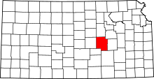 | |
| Unincorporated communities | ||
| Ghost towns | ||
| Townships | ||
| Footnotes | ‡This populated place also has portions in an adjacent county or counties | |
This article is issued from Wikipedia - version of the 7/29/2014. The text is available under the Creative Commons Attribution/Share Alike but additional terms may apply for the media files.