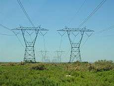
Path 26
Path 26 is a set of three Southern California Edison (SCE) 500 kV power lines, located primarily in Los Angeles County, and extending into Kern and Ventura counties, all in California. The Path 26 lines are located in: the San Joaquin Valley of the southern Central Valley; the Tehachapi Mountains and other central Transverse Ranges; and the Antelope Valley section of the Mojave Desert.[1][2]
Power grids link
Path 26 forms Southern California Edison's (SCE) intertie (link) with Pacific Gas & Electric (PG&E) to the north. Since PG&E's power grid and SCE's grid both have interconnections to elsewhere, in the Pacific Northwest (PG&E) and the Southwestern United States (SCE), Path 26 is a southern extension of Path 15 and Path 66, and a crucial link between the two regions' grids.[3]
Transmission lines
The path consists of three transmission lines, Midway–Vincent No. 1, Midway–Vincent No. 2 and Midway–Whirlwind. Midway–Whirlwind was part of what was called Midway–Vincent No. 3 before Whirlwind was built, as part of the Tehachapi Renewable Transmission Project.
Power transmission capacity
The three Path 26 500 kV lines can transmit 3,700 MW of electrical power north to south. The capacity for south to north power transmission is 3,000 MW.[3]
Expansion
For a long time, people have talked about building a fourth line, but no one has done anything about it. It is a bottleneck since power from the Pacific Northwest (Oregon, Washington, and other places) can go to Northern California but not Southern California when this path is causing congestion. Also, California's main nuclear plant is on one side, now that San Onofre Nuclear Generating Station is out of operation. California Independent System Operator says that an improvement would decrease prices south of the path but increase prices north of it, so it is not economical.[4]
Route

Path 26 - Vincent to Midway
The Path, starting from the south, starts at the large Vincent substation close to State Route 14 and Soledad Pass near Acton east of the Santa Clarita Valley. The same Vincent substation is linked to Path 46 and Path 61 via two SCE 500 kV lines that head southeast to Lugo substation. As for these SCE 500 kV wires, like Path 15 to the north, the three 500 kV wires are never built together for the entire length of the route. Straight from the substation, all three lines head north-northwest. The westernmost SCE 500 kV line splits away and runs west of the other two SCE 500 kV lines.[2]
After crossing State Route 14, two 500 kV wires built by Los Angeles Department of Water and Power (LADW&P) join the eastern two SCE 500 kV wires. Some point west of Palmdale, one line (SCE) continues northwest and the other three (one SCE, two LADW&P) head west. The lone SCE line continuing northwest (with 230 kV lines) runs close to the Antelope Valley California Poppy Reserve, famed for its California Poppy flowers. The one SCE line that ran west of the other two SCE lines (now separated) re-joins the single SCE 500 kV running west with the two LADW&P lines. The four 500 kV lines run together for some distance until, at some point in the mountains, the two SCE lines continue to head west and the two LADW&P lines turn southwest and head for Sylmar in the San Fernando Valley (close to the Sylmar Converter Station southern terminus of the Pacific Intertie HVDC line). The two SCE lines heading west meet up with Interstate 5 on the arid foothills of the Sierra Pelona Mountains to the east of Pyramid Lake. The lines parallel I-5 crossing Tejon Pass (running on the eastern foothills of Frazier Mountain) and run out of sight for a while as they cross the high woodlands of the northern San Emigdio Mountains at their highest point at around 5,350 ft (1,630 m).[2][5]
As for the third line, north of Lancaster and State Route 138, it runs through a remote, roadless area of the Tehachapi Mountains with two 230 kV lines. Although it runs across sparse to dense oak woodlands at around 5,300 ft (1,615 m),[5] it is not easy to spot it on Google Earth since its right of way is not as clear cut as Path 15 and Path 66 to the north. Due to this, the line is not readily seen again until it crosses State Route 184 as a PG&E power line. Somewhere to the east of State Route 184, in the mountains, the line changes from SCE towers to PG&E towers.[2][6][7] By the time the all three lines are visible to Interstate 5, they roughly parallel each other until all three lines, two SCE and one PG&E, terminate at the massive Midway substation in Buttonwillow in the San Joaquin Valley.[8] Two pairs of PG&E 500 kV lines heading north and southwest (separated), form Path 15.[2]
Connecting wires to Path 46 - Vincent to Lugo
Adjacent to the Path 26 wires, two other SCE 500 kV also begin in Vincent substation. The two 500 kV power lines head northeast from Vincent to meet up with LADW&P's two other 500 kV wires from Rinaldi and then all four lines head east in the Antelope Valley along the northern foothills of the San Gabriel Mountains. Another LADW&P line from Toluca joins the four-line transmission corridor, resulting in a large path of five power lines. However, one LADW&P splits off from the other four lines and heads southeast. Soon after, the SCE lines split away from the remaining two LADW&P lines and head southeast as well. They cross the lone LADW&P line that split away and Interstate 15 as they head to the Lugo substation northeast of Cajon Pass. The lines terminate at Lugo, where one SCE Path 61 500 kV line, two SCE Path 46 500 kV lines, and three other SCE 500 kV lines end.[2][9][10]
References
- ↑ "Energy Infrastructure Map of Southern California". Retrieved 2013-05-29.
- 1 2 3 4 5 6 Route descriptions and tower designs are based on Google Earth images.
- 1 2 "Paths 21-30". Western Electricity Coordinating Council. 2006.
- ↑ "Board-Approved 2013-2014 Transmission Plan Jul 16, 2014" (PDF). California Independent System Operator.
- 1 2 Google Earth elevation for GNIS coordinates.
- ↑ "Picture of Path 26 on State Route 99". WestCoastRoads.com. Retrieved 2007-09-21.
- ↑ "Picture of Path 26 on Interstate 5". WestCoastRoads.com. Retrieved 2007-09-21.
- ↑ "Picture of Midway Substation on State Route 58". WestCoastRoads.com. Retrieved 2007-09-21.
- ↑ "Paths 41-50". Western Electricity Coordinating Council. 2006.
- ↑ "Paths 61-70". Western Electricity Coordinating Council. 2006.