Parlin, Colorado
| Parlin, Colorado | |
|---|---|
| Unincorporated community | |
|
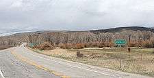
Entering Parlin | |
 Parlin  Parlin | |
| Coordinates: 38°30′11″N 106°43′34″W / 38.50306°N 106.72611°WCoordinates: 38°30′11″N 106°43′34″W / 38.50306°N 106.72611°W | |
| Country |
|
| State |
|
| County | Gunnison County[1] |
| Elevation[1] | 7,933 ft (2,418 m) |
| Time zone | MST (UTC-7) |
| • Summer (DST) | MDT (UTC-6) |
| ZIP code[2] | 81239 |
| GNIS feature ID | 0189019 |
Parlin is an unincorporated community and a U.S. Post Office in Gunnison County, Colorado, United States. The Parlin Post Office has the ZIP Code 81239.[2]
Geography
Parlin is located at 38°30′11″N 106°43′34″W / 38.50306°N 106.72611°W (38.503042, -106.726170).
History
The town is named after rancher John Parlin who moved to the area from Maine in 1877.[3]
Climate
Climate type is dominated by the winter season, a long, bitterly cold period with short, clear days, relatively little precipitation mostly in the form of snow, and low humidity. The Köppen Climate Classification sub-type for this climate is "Dfc" (Continental Subarctic Climate).
| Climate data for Parlin, Colorado | |||||||||||||
|---|---|---|---|---|---|---|---|---|---|---|---|---|---|
| Month | Jan | Feb | Mar | Apr | May | Jun | Jul | Aug | Sep | Oct | Nov | Dec | Year |
| Average high °C (°F) | −2 (28) |
1 (33) |
6 (43) |
12 (54) |
18 (65) |
24 (76) |
27 (81) |
26 (79) |
22 (72) |
16 (61) |
7 (45) |
−1 (31) |
13 (56) |
| Average low °C (°F) | −21 (−5) |
−18 (0) |
−11 (12) |
−6 (21) |
−2 (29) |
2 (35) |
6 (42) |
5 (41) |
0 (32) |
−6 (22) |
−12 (11) |
−18 (−1) |
−7 (20) |
| Average precipitation mm (inches) | 18 (0.7) |
15 (0.6) |
18 (0.7) |
20 (0.8) |
23 (0.9) |
18 (0.7) |
41 (1.6) |
46 (1.8) |
30 (1) |
20 (0.8) |
15 (0.6) |
20 (0.8) |
280 (11) |
| Average precipitation days | 6 | 6 | 6 | 6 | 6 | 5 | 9 | 10 | 6 | 5 | 5 | 6 | 76 |
| Source: Weatherbase [4] | |||||||||||||
See also
References
- 1 2 "US Board on Geographic Names". United States Geological Survey. 2007-10-25. Retrieved 2008-01-31.
- 1 2 "ZIP Code Lookup". United States Postal Service. January 2, 2007. Archived from the original (JavaScript/HTML) on November 23, 2010. Retrieved 2007-01-02.
- ↑ Hall, F.; Rocky Mountain Historical Company (1895). History of the State of Colorado, Embracing Accounts of the Pre-historic Races and Their Remains: The Earliest Spanish, French and American Explorations ... the First American Settlements Founded; the Original Discoveries of Gold in the Rocky Mountains; the Development of Cities and Towns, with the Various Phases of Industrial and Political Transition, from 1858 to 1890 ... Blakely print. Company. p. 546. Retrieved 2014-11-23.
- ↑ "Weatherbase.com". Weatherbase. 2013. Retrieved on August 3, 2013.
Municipalities and communities of Gunnison County, Colorado, United States | ||
|---|---|---|
| City | 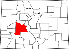 | |
| Towns | ||
| Unincorporated communities | ||
| Ghost town | ||
This article is issued from Wikipedia - version of the 11/18/2016. The text is available under the Creative Commons Attribution/Share Alike but additional terms may apply for the media files.