Ohio City, Colorado
| Ohio City, Colorado Ohio, Colorado | |
|---|---|
| Unincorporated community | |
|
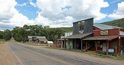
Ohio City in 2014 | |
 Ohio City  Ohio City | |
| Coordinates: 38°34′04″N 106°34′02″W / 38.56778°N 106.56722°WCoordinates: 38°34′04″N 106°34′02″W / 38.56778°N 106.56722°W | |
| Country |
|
| State |
|
| County | Gunnison[1] |
| Elevation[1] | 8,570 ft (2,612 m) |
| Time zone | MST (UTC-7) |
| • Summer (DST) | MDT (UTC-6) |
| ZIP code[2] | 81237 |
| GNIS feature ID | 0189049 |
Ohio City is an unincorporated community and a U.S. Post Office in Gunnison County, Colorado, United States. The Ohio City Post Office has the ZIP Code 81237.[2]
History
In 1879, a prospector, miner, and assayer named Jacob Hess discovered silver in Ohio Creek, now known as Gold Creek He moved his camp to Ohio Creek and named his settlement Eagle City, officially becoming Ohio City's first settler. In 1881, Ohio City was surveyed and platted. The following year, the Denver, South Park and Pacific Railroad was built through the town. By 1898, Ohio City was nearly deserted.[3]
Mines
In 1898, the Cortland Mine in McIntyre Gulch was the only mine operating in the district. Three Harvard University students, the Carter brothers, surveyed land during the summers at the turn of the century. One brother, Carroll M. Carter, organized the Carter Mining Company.
Around the same time, E. M. Lamont organized the Raymond Consolidated Mines Company which mined locally.
From 1908-1912, the Colorado Smelting and Mining Company, headed by A. E. Reynolds, mined the Sacramento mine and the Silver Islet mine.[4]
Geography
Ohio City is located at 38°34′04″N 106°34′02″W / 38.56778°N 106.56722°W (38.567764,-106.567211).
Climate
Climate type is dominated by the winter season, a long, bitterly cold period with short, clear days, relatively little precipitation mostly in the form of snow, and low humidity. The Köppen Climate Classification sub-type for this climate is "Dfc" (Continental Subarctic Climate).[5]
| Climate data for Ohio City, Colorado | |||||||||||||
|---|---|---|---|---|---|---|---|---|---|---|---|---|---|
| Month | Jan | Feb | Mar | Apr | May | Jun | Jul | Aug | Sep | Oct | Nov | Dec | Year |
| Average high °C (°F) | −3 (26) |
−1 (31) |
6 (42) |
13 (56) |
19 (66) |
24 (76) |
27 (81) |
26 (79) |
22 (72) |
16 (61) |
7 (45) |
−1 (30) |
13 (55) |
| Average low °C (°F) | −22 (−7) |
−19 (−2) |
−12 (11) |
−6 (22) |
−2 (29) |
2 (36) |
6 (43) |
5 (41) |
0 (32) |
−6 (22) |
−12 (10) |
−19 (−3) |
−7 (19) |
| Average precipitation mm (inches) | 20 (0.8) |
20 (0.8) |
18 (0.7) |
18 (0.7) |
20 (0.8) |
18 (0.7) |
38 (1.5) |
36 (1.4) |
30 (1) |
18 (0.7) |
15 (0.6) |
20 (0.8) |
262 (10.3) |
| Source: Weatherbase [6] | |||||||||||||
References
- 1 2 "US Board on Geographic Names". United States Geological Survey. 2007-10-25. Retrieved 2008-01-31.
- 1 2 "ZIP Code Lookup". United States Postal Service. January 2, 2007. Archived from the original (JavaScript/HTML) on December 14, 2006. Retrieved January 2, 2007.
- ↑ Crawford, R. (1916). Colorado Geological Survey: Boulder: Bulletin 10: Geology and Ore Deposits of the Gold Brick District: Colorado. Denver: Eames Brothers, State Printers. p. 12.
- ↑ Crawford, R. (1916). Colorado Geological Survey: Boulder: Bulletin 10: Geology and Ore Deposits of the Gold Brick District: Colorado. Denver: Eames Brothers, State Printers. pp. 12–13.
- ↑ Climate Summary for Ohio City, Colorado
- ↑ "Weatherbase.com". Weatherbase. 2013. Retrieved on August 3, 2013.
Municipalities and communities of Gunnison County, Colorado, United States | ||
|---|---|---|
| City | 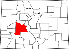 | |
| Towns | ||
| Unincorporated communities | ||
| Ghost town | ||