Marble, Colorado
| Town of Marble, Colorado | |
|---|---|
| Statutory Town | |
|
Old Marble High School, built in 1910 | |
 Location in Gunnison County and the state of Colorado | |
| Coordinates: 39°4′20″N 107°11′22″W / 39.07222°N 107.18944°WCoordinates: 39°4′20″N 107°11′22″W / 39.07222°N 107.18944°W | |
| Country |
|
| State |
|
| County[1] | Gunnison |
| Incorporated | 1899 |
| Government | |
| • Type | Statutory Town[1] |
| Area | |
| • Total | 0.4 sq mi (1.0 km2) |
| • Land | 0.4 sq mi (1.0 km2) |
| • Water | 0.0 sq mi (0.0 km2) |
| Elevation[2] | 7,992 ft (2,436 m) |
| Population (2010) | |
| • Total | 131 |
| • Density | 330/sq mi (130/km2) |
| Time zone | Mountain (MST) (UTC-7) |
| • Summer (DST) | MDT (UTC-6) |
| ZIP code[3] | 81623 |
| Area code(s) | 970 |
| FIPS code | 08-48555 |
| GNIS feature ID | 0175531 |
| Highways | none |

The Town of Marble is a Statutory Town in Gunnison County, Colorado, United States. The town population was 131 at the 2010 United States Census.[4]
History
The Town of Marble was first incorporated in 1899. Marble remains a statutory town of the State of Colorado today.
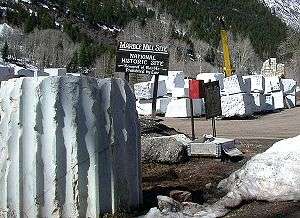
The quarry
The town is the location of a historic Yule Marble quarry along the mountains that began operations in the late 19th century, and from which the town draws its name. The marble of the quarry is considered to be of exceptional quality and has been used for the Tomb of the Unknowns, as well as for parts of the Lincoln Memorial in Washington, D.C., and civic buildings in San Francisco. It was also used for the construction of the Equitable Building, a historically important early skyscraper in New York City.
The quarry has enjoyed a renaissance since its acquisition in 2004 by Polycor, a Canadian-based dimension stone company. In spite of significant transportation costs, this high-quality stone is now exported in large quantities to Europe and Asia for transformation and use throughout the world, as well as being sold into the US market.
Tourism
In the late 20th century and the 21st century, Marble has become a summer tourist destination, benefiting from the quarry's renown. It is also the gateway to the nearby Crystal townsite. It is the site of the Marble/marble sculpting symposium held every summer since 1988.
Seven sites within Marble have been listed on the National Register of Historic Places.[5]
- Haxby House
- William D. Parry House
- St. Paul's Church
- Marble City State Bank building
- Marble High School
- Marble Mill Site
- Marble Town Hall
Geography
Marble is located at 39°4′20″N 107°11′22″W / 39.07222°N 107.18944°W (39.072274, -107.189516).[6]
According to the United States Census Bureau, the town has a total area of 0.4 square miles (1.0 km2), all of it land.
The community is located in a valley of the upper Crystal River along the Elk Mountains, accessible by a paved road from State Highway 133. Unlike most of Gunnison County, the town is located on the north side of Schofield Pass and thus is separated geographically from the rest of Gunnison county.
Demographics
| Historical population | |||
|---|---|---|---|
| Census | Pop. | %± | |
| 1900 | 101 | — | |
| 1910 | 782 | 674.3% | |
| 1920 | 81 | −89.6% | |
| 1930 | 217 | 167.9% | |
| 1940 | 240 | 10.6% | |
| 1950 | 8 | −96.7% | |
| 1960 | 5 | −37.5% | |
| 1970 | 13 | 160.0% | |
| 1980 | 30 | 130.8% | |
| 1990 | 64 | 113.3% | |
| 2000 | 105 | 64.1% | |
| 2010 | 131 | 24.8% | |
| Est. 2015 | 135 | [7] | 3.1% |
As of the census[9] of 2000, there were 105 people, 45 households, and 27 families residing in the town. The population density was 282.2 people per square mile (109.6/km²). There were 74 housing units at an average density of 198.9 per square mile (77.2/km²). The racial makeup of the town was 99.05% White, 0.95% from other races. Hispanic or Latino of any race were 0.95% of the population.
There were 45 households out of which 22.2% had children under the age of 18 living with them, 60.0% were married couples living together, and 40.0% were non-families. 26.7% of all households were made up of individuals and 4.4% had someone living alone who was 65 years of age or older. The average household size was 2.33 and the average family size was 2.89.
In the town the population was spread out with 20.0% under the age of 18, 2.9% from 18 to 24, 27.6% from 25 to 44, 42.9% from 45 to 64, and 6.7% who were 65 years of age or older. The median age was 44 years. For every 100 females there were 118.8 males. For every 100 females age 18 and over, there were 133.3 males.
The median income for a household in the town was $46,094, and the median income for a family was $47,292. Males had a median income of $29,375 versus $20,000 for females. The per capita income for the town was $18,509. There were no families and 2.7% of the population living below the poverty line, including no under eighteens and none of those over 64.
See also
References
- 1 2 "Active Colorado Municipalities". State of Colorado, Department of Local Affairs. Retrieved 2007-09-01.
- ↑ "US Board on Geographic Names". United States Geological Survey. 2007-10-25. Retrieved 2008-01-31.
- ↑ "ZIP Code Lookup" (JavaScript/HTML). United States Postal Service. Retrieved November 18, 2007.
- ↑ "Race, Hispanic or Latino, Age, and Housing Occupancy: 2010 Census Redistricting Data (Public Law 94-171) Summary File (QT-PL), Marble town, Colorado". U.S. Census Bureau, American FactFinder 2. Retrieved August 16, 2011.
- ↑ National Park Service (2010-07-09). "National Register Information System". National Register of Historic Places. National Park Service.
- ↑ "US Gazetteer files: 2010, 2000, and 1990". United States Census Bureau. 2011-02-12. Retrieved 2011-04-23.
- ↑ "Annual Estimates of the Resident Population for Incorporated Places: April 1, 2010 to July 1, 2015". Retrieved July 2, 2016.
- ↑ "Census of Population and Housing". Census.gov. Retrieved June 4, 2015.
- ↑ "American FactFinder". United States Census Bureau. Retrieved 2008-01-31.
External links
| Major cities | 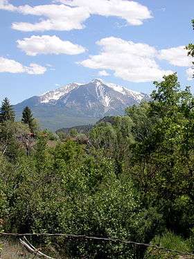 | |
|---|---|---|
| Other communities | ||
| Near valley | ||
| Ski resorts | ||
| Bodies of water | ||
Municipalities and communities of Gunnison County, Colorado, United States | ||
|---|---|---|
| City | 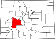 | |
| Towns | ||
| Unincorporated communities | ||
| Ghost town | ||
