Paraćin
| Paraćin Параћин | ||
|---|---|---|
| Municipality and Town | ||
 | ||
| ||
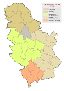
 Location of the municipality of Paraćin within Serbia | ||
| Coordinates: 43°52′N 21°25′E / 43.867°N 21.417°ECoordinates: 43°52′N 21°25′E / 43.867°N 21.417°E | ||
| Country |
| |
| District | Pomoravlje | |
| Settlements | 35 | |
| Government | ||
| • Mayor | Saša Paunović (DS) | |
| Area[1] | ||
| • Municipality | 542 km2 (209 sq mi) | |
| Population (2011 census)[2] | ||
| • Town | 24,573 | |
| • Municipality | 54,267 | |
| Time zone | CET (UTC+1) | |
| • Summer (DST) | CEST (UTC+2) | |
| Postal code | 35250 | |
| Area code | +381 35 | |
| Car plates | PN | |
| Website |
www | |

Paraćin (Serbian Cyrillic: Параћин, pronounced [pâratɕin]) is a town and municipality in Serbia, located in the valley of the Velika Morava river, north of Kruševac and southeast of Kragujevac. In 2011 the town has total population of 24,573 and has a civil airport.
History
8th century BC Basarabi pottery was found with the depiction of domestic cock.[3] The Roman fort at Momčilov Grad produced a great number of coins of Byzantine Emperor Justinian (525–565).[4]
From 1929 to 1941, Paraćin was part of the Morava Banovina of the Kingdom of Yugoslavia.
Settlements
Apart from the town of Paraćin, the municipality includes the following settlements, along with number of residents (2002 census):
|
Notable citizens
- Ana Nikolić, Serbian pop singer
- Bojan Krkić, Spanish footballer of Serbian origin
- Ivana Sert, Serbian-Turkish TV personality, model, and fashion designer.
- Marčelo, Serbian hip hop musician
- Nenad Đorđević, Serbian footballer
International relations
Twin towns — Sister cities
Paraćin is twinned with:
 Eleftherio-Kordelio, Greece
- Perdika, Greece
 Murska Sobota, Slovenia
 Jablanica, Bosnia and Herzegovina
References
- ↑ "Municipalities of Serbia, 2006". Statistical Office of Serbia. Retrieved 2010-11-28.
- ↑ "2011 Census of Population, Households and Dwellings in the Republic of Serbia: Comparative Overview of the Number of Population in 1948, 1953, 1961, 1971, 1981, 1991, 2002 and 2011, Data by settlements" (PDF). Statistical Office of Republic Of Serbia, Belgrade. 2014. ISBN 978-86-6161-109-4. Retrieved 2014-06-27.
- ↑ Función depuradora de los humedales I: una revisión bibliográfica sobre el papel de los macrófitos (Spanish)
- ↑
External links
| Wikimedia Commons has media related to Paraćin. |
- Official web presentation of Paraćin Municipality
- The independent portal of Paracin
- Cultural Center of Paraćin
- Paraćin kao na Dlanu

This article is issued from Wikipedia - version of the 11/9/2016. The text is available under the Creative Commons Attribution/Share Alike but additional terms may apply for the media files.