Sremski Karlovci
For the forester, see Hans Carl von Carlowitz.
| Sremski Karlovci Сремски Карловци | ||
|---|---|---|
| Municipality and Town | ||
|
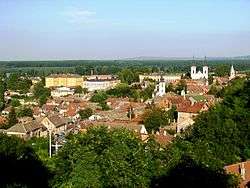
Sremski Karlovci panoramic view | ||
| ||
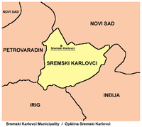
 Location of the municipality of Sremski Karlovci within Serbia | ||
| Coordinates: 45°12′N 19°56′E / 45.200°N 19.933°ECoordinates: 45°12′N 19°56′E / 45.200°N 19.933°E | ||
| Country | Serbia | |
| Province | Vojvodina | |
| District | South Bačka | |
| Settlements | 1 | |
| Government | ||
| • Mayor | Nenad Milenković (SNS) | |
| Area[1] | ||
| • Municipality | 51 km2 (20 sq mi) | |
| Population (2011 census)[2] | ||
| • Town | 8,722 | |
| • Municipality | 8,722 | |
| Time zone | CET (UTC+1) | |
| • Summer (DST) | CEST (UTC+2) | |
| Postal code | 21205 | |
| Area code | +381 21 | |
| Car plates | NS | |
| Website |
www | |

Sremski Karlovci (Serbian Cyrillic: Сремски Карловци, pronounced [srêːmskiː kâːrloːʋt͡si]) is a town and municipality in Serbia, in the autonomous province of Vojvodina, situated on the bank of the river Danube, 8 kilometres (5 miles) from Novi Sad. The population in 2011 was 8,722. The town has traditionally been known as the seat of Serbian Orthodox Church in the Habsburg Monarchy, as well as political and cultural capital of Serbian Vojvodina after the May Assembly and during the Revolution in 1848.
Name
In Serbian, the town is known as Sremski Karlovci (Сремски Карловци), in Croatian as Srijemski Karlovci, in German as Karlowitz or Carlowitz, in Hungarian as Karlóca, in Polish as Karłowice, in Romanian as Carloviț and in Turkish as Karlofça. The former Serbian name used for the town was Karlovci (Карловци) - it is used today as well, but unofficially.
Geography
The town is situated in the geographical region of Syrmia, but it is part of South Bačka District. The town of Sremski Karlovci is the only settlement in the municipality.
History
Ancient, medieval and early modern history
In ancient times, a small Roman fortress existed at this location. The town was first mentioned in historical documents in 1308 with the name Karom. The fortress of Karom was built on the ruins of the ancient Roman one. Until 1521, the Karom was a possession of the Hungarian noble families, of which the most well known were Báthory and Morović.
Turkish military commander Bali-beg conquered Karom in 1521, and in the next 170 years, the town was part of the Ottoman Empire. The Slavic name for the town - Karlovci, was first recorded in 1532/33. During the Ottoman rule, the town was mostly populated by Serbs, with the smaller part of population composed of Muslims. According to the Ottoman defterler from 1545, the population of Karlovci numbered 547 Christian (Serb) houses, thus it was the largest city with a Serb majority in the whole Ottoman Empire. The city also had three Orthodox churches and a monastery.
Habsburg Monarchy

Between 16 November 1698 and 26 January 1699, the town of Karlovci was the site of a congress that ended the hostilities between the Ottoman Empire and the Holy League, a coalition of various European powers including Habsburg Monarchy, Poland, Venice and Russia; the congress produced the Treaty of Karlowitz. It was the first time a round table was used in international politics.
After this peace treaty, the town was part of the Habsburg Monarchy and was included into the Military Frontier. According to the 1702 data, the population of the town was composed of 215 Orthodox and 13 Catholic houses, while according to the 1753 data, the population of the town numbered 3,843 people, of which 3,110 were ethnic Serbs.
The town was also the spiritual, political and cultural centre of the Serbs in the Habsburg Monarchy. The Metropolitan of the Serb Orthodox Church resided in the town. To this day, the Serbian Patriarch retains the title of Metropolitan of Karlovci. The town also featured the earliest Serb (and Slavic in general) gymnasium (Serbian: gimnazija/гимназија, French: lycée) founded on 3 August 1791. Three years after this, an Orthodox seminary was also founded in the town: it was the second oldest Orthodox seminary in the world (after the Spiritual Academy in Kiev), and it is still in existence.
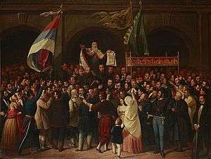
At the Serb National Assembly in Karlovci in May 1848, Serbs declared the unification of the regions of Srem, Banat, Bačka, and Baranja (including parts of the Military Frontier) into the province of Serbian Vojvodina. The first capital of Serbian Vojvodina was in Karlovci, until it was latter moved to Zemun, Veliki Bečkerek, and Temišvar. In the same time the title of the Orthodox Metropolitan of Karlovci was raised to that of Patriarch, which thus established an Orthodox Patriarchate of Karlovci that existed until 1920 when it was joined with the Metropolitanate of Belgrade to form the new Serbian Patriarchate.
When Serbian Vojvodina was in 1849 transformed into the new province named Voivodeship of Serbia and Banat of Temeschwar, town of Karlovci was not included into this province, but was returned under the administration of the Military Frontier (Petrovaradin regiment that was part of Slavonian Krajina). With the abolishment of the Military Frontier in 1881, the town was included into Syrmia County of Croatia-Slavonia, the autonomous kingdom within Kingdom of Hungary and Austria-Hungary.
After 1918

In 1918, the town became part of the Kingdom of Serbs, Croats and Slovenes. In the 1920s, it became the headquarters of Russian White émigrés of General Wrangel whose monument remains to this day. It was also an early home to the Holy Synod of the Russian Orthodox Church Outside Russia. (Critics labeled this church the "Karlovtsy Synod" in its early days in an attempt to belittle its importance as an international Orthodox body.)
Between 1929 and 1941, the town was part of Danube Banovina, a province of the Kingdom of Yugoslavia. During World War 2 (1941–1944), the town was occupied by the Axis Powers and it was attached to the Independent State of Croatia. During that time its name was changed to Hrvatski Karlovci. Since the end of the war, the town has been part of the Autonomous Province of Vojvodina.
Between 1980 and 1989, Sremski Karlovci was one of the seven municipalities of Novi Sad City. Today, the municipality is not part of Novi Sad City, but a separate administrative unit of South Bačka District.
Most recently, the government of Serbia announced its decision to move the Constitutional Court of Serbia to this town as part of the national strategy for decentralization. Furthermore, the government decided to make this move because of the historic importance of this town in Serbian history as well because of its relative proximity to the capital, Belgrade. The court will probably occupy the building of the magistrate some time during 2010. In this way the government plans to symbolically, amongst other things, crown the reform of the judicial system and mark the separation of the three branches of government and emphasize their mutual independence.
Historical population of the town
- 1961: 6,390
- 1971: 7,040
- 1981: 7,547
- 1991: 7,534
- 2011: 8,722
Ethnic groups (2002 census)
The population of the Sremski Karlovci municipality:
- Serbs (75.39%)
- Croats (8.51%)
- Yugoslavs (2.87%)
- Hungarians (2.43%)
- Montenegrins (1%)
Politics
Until 1989 Sremski Karlovci formed one of the urban municipalities of the city of Novi Sad. After Novi Sad merged six of its municipalities into one Novi Sad municipality, the municipality of Sremski Karlovci held a referendum to separate from Novi Sad, and established a separate municipality independent from Novi Sad. Although Sremski Karlovci lies in Syrmia region, the municipality belongs in South Bačka District, and not in the Syrmia District, because of its close proximity to Novi Sad.
In the Serbian local elections held on 24 April 2016, Sremski Karlovci elected a new municipality parliament, ending the rule of the DS in the town. Nenad Milenković, from SNS, was elected as the new mayor of the municipal parliament.
Schools
International relations
Twin towns – Sister cities
Sremski Karlovci is twinned with:
|
|
Gallery

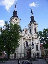 The Orthodox Cathedral of St. Nicholas
See also
- Buildings and structures in Sremski Karlovci
- Fruška Gora
- Syrmia
- List of places in Serbia
- List of cities, towns and villages in Vojvodina
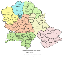
- Spatial Cultural-Historical Units of Exceptional Importance
Literature
- Milorad Grujić, Vodič kroz Novi Sad i okolinu, Novi Sad, 2004.
- Slobodan Ćurčić, Broj stanovnika Vojvodine, Novi Sad, 1996.
References
- ↑ "Municipalities of Serbia, 2006". Statistical Office of Serbia. Retrieved 2010-11-28.
- ↑ "2011 Census of Population, Households and Dwellings in the Republic of Serbia: Comparative Overview of the Number of Population in 1948, 1953, 1961, 1971, 1981, 1991, 2002 and 2011, Data by settlements" (PDF). Statistical Office of Republic Of Serbia, Belgrade. 2014. ISBN 978-86-6161-109-4. Retrieved 2014-06-27.
- ↑ "National Commission for Decentralised cooperation". Délégation pour l’Action Extérieure des Collectivités Territoriales (Ministère des Affaires étrangères) (in French). Retrieved 2013-12-26.
- ↑ "Между городами Новый Афон и Сремски-Карловцы подписан Договор о сотрудничестве". Apsnypress. 23 December 2014. Retrieved 8 March 2015.
External links
| Wikimedia Commons has media related to Sremski Karlovci. |
| Wikivoyage has a travel guide for Sremski Karlovci. |
- www.sremski-karlovci.org.rs (Official site)
 "Karlowitz". Encyclopædia Britannica (11th ed.). 1911.

| Archaeological sites |  | |
|---|---|---|
| Cultural Monuments | ||
| Historic Landmarks | ||
| Spatial Cultural-Historical Units | ||