Barajevo
| Barajevo Барајево | ||
|---|---|---|
| Municipality and Town | ||
| ||
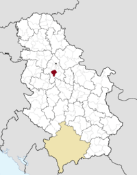 Location of the municipality of Barajevo within Serbia | ||
| Coordinates: 44°35′N 20°25′E / 44.583°N 20.417°ECoordinates: 44°35′N 20°25′E / 44.583°N 20.417°E | ||
| Country |
| |
| District | Belgrade | |
| Settlements | 13 | |
| Government | ||
| • Mayor | Slobodan Adamović (SNS) | |
| Area[1] | ||
| • Municipality | 213 km2 (82 sq mi) | |
| Population (2011 census)[2] | ||
| • Town | 8,325 | |
| • Municipality | 24,641 | |
| Time zone | CET (UTC+1) | |
| • Summer (DST) | CEST (UTC+2) | |
| Postal code | 11460 | |
| Area code | +381 11 | |
| Car plates | BG | |
| Website |
www | |
.gif)
Barajevo (Serbian Cyrillic: Барајево, pronounced [bǎrajɛv̞ɔ]) is a suburban settlement and one of 17 municipalities which constitute the City of Belgrade, the capital of Serbia.
Municipality
Settlements
The municipality of Barajevo covers an area of 213 km² and includes 13 settlements, all of which are statistically classified as rural, not urban:
- Arnajevo
- Baćevac
- Barajevo
- Beljina
- Boždarevac
- Guncati
- Lisović
- Manić
- Meljak
- Rožanci
- Šiljakovac
- Veliki Borak
- Vranić
It also includes various sub-settlements and hamlets spawning around the central settlements:
|
|
Population
Municipality has a population of 24,641 (census 2002), with an estimated 26,449 inhabitants on 31 December 2005 (124 per km²). Thanks to the immigration, it is one of the fastest growing areas of Belgrade, with an average annual growth of 2%. The rapid population growth is not followed by the equal development of infrastructure (good roads, waterworks, sewage system, waste disposal) even though in 2005 a construction of major water processing plant was finished. Two major traffic routes, the Ibarska magistrala (Highway of Ibar) and the railway Belgrade-Bar (Montenegro), are passing through the municipal territory.
Population of the municipality:
- 1961: 17,461
- 1971: 16,552
- 1981: 18,815
- 1991: 20,846
- 2002: 24,641
- 2005: 26.449
Ethnic structure (census 2002): Serbs 94,5%, Romani 0,8%, Montenegrins 0,7%.
Location
Municipality is located in the low part of Šumadija, southeast of the Belgrade, with an elevation spanning from 140 to 364 m. Most of the municipal territory belongs to the drainage area of the Turija river, right tributary of the Peštan river, which in turn flows into the Kolubara, thus whole area geographically gravitates to the Kolubara region.
History
Municipality was created in 1956 and immediately became administratively part of the wider Belgrade area. In 1957 a nearby municipality of Beljina was annexed to Barajevo, and in 1960 Umka municipality has been divided between Čukarica and Barajevo (villages of Meljak and Vranić).
Recent presidents of the municipal assembly:
- 2000 - February 9, 2001; Zoran Jevtić (1947)
- February 9, 2001 - November 1, 2001; Miodrag Skoknić (1931) (acting)
- November 1, 2001 - February 20, 2003; Dragoljub Stanić (acting)
- February 20, 2003 - February 12, 2007; Rade Stevanović (1956)
- February 12, 2007 - February 21, 2007; Branislav Đurić (acting)
- February 12, 2007 - May, 2007; Rade Stevanović (second time)
- May, 2007 - June 25, 2007; Igor Jevtić (1975) (acting)
- June 25, 2007 - 2015; Branka Savić (1956)
- Slobodan Adamović 15.06.2016 - ongoing (SNS)
Settlement
Location and population
The settlement itself is still statistically classified as a rural (village). It is growing by even higher rate than the municipality as a whole (census 2002, 8,325 inhabitants; estimate 31 December 2005, 9,231 inhabitants; annual growth rate of 2,9%). It is located east of the 'Parcanski vis' hill, northern part of the Kosmaj mountain, in the valley of the Beljanica river (or Barajevska reka; Cyrillic: Бељаница or Барајевска река), a tributary to the Turija river.
Population of the settlement:
- 1921: 2,330
- 1953: 3,361
- 1971: 3,486
- 1981: 4,225
- 1991: 6,093
- 2002: 8,325
- 2005: 9,231
Many outer settlements and hamlets are built as Barajevo grows and stretches in all directions making one continuous built-up are with the neighboring settlements (Guncati, Baćevac, Lisović, Boždarevac, Guberevac in Sopot municipality): Bela Reka, Dražanovac, Dubrave, Gaj (a separate local community with a population of 1,930 in 2002), Glumčevo Brdo (a separate local community, split after the 2002 census), Karaula, Nenadovac, Pajšuma, Ravni Gaj, Srednji Kraj, Stara Lipovica, Suva Šuma, Trebež (the industrial zone), Vitkovica.
Economy
The economy is not much developed. Being an agricultural area, Barajevo has a mill, large orchard farm, a veterinarian station and the hunting & forestry company of Lipovička šuma. Wheat, barley, oats and corn are being grown. Industry is based on the small construction and electronic companies and the ball bearing factory.
Barajevo is outside major roads, but it is located on the Belgrade-Bar railway. The settlement itself was further away, but as it grew, it reached the railway.
Culture and tradition
Cultural festival, the Barlet, (Barajevo summer) is held annually. Artificial lake 'Duboki potok' (Cyrillic: Дубоки поток; Deep brook) is located near the Barajevo, with the large weekend-settlement.
First mention of the name Barajevo is from the 16th century. The popular story that the settlement got its name from the multitude of springs in this area [Serbian: bara je ovo (this is a pond)] is probably not true.
The Farm
Reality show The Farm is captured in village Lisović.[3]
See also
References
- Mala Prosvetina Enciklopedija, Third edition (1985); Prosveta; ISBN 86-07-00001-2
- Jovan Đ. Marković (1990): Enciklopedijski geografski leksikon Jugoslavije; Svjetlost-Sarajevo; ISBN 86-01-02651-6
- Srpska porodična enciklopedija, Vol. II (2006); Narodna knjiga and Politika NM; ISBN 86-331-2731-8
- ↑ "Municipalities of Serbia, 2006". Statistical Office of Serbia. Retrieved 2010-11-28.
- ↑ "2011 Census of Population, Households and Dwellings in the Republic of Serbia: Comparative Overview of the Number of Population in 1948, 1953, 1961, 1971, 1981, 1991, 2002 and 2011, Data by settlements" (PDF). Statistical Office of Republic Of Serbia, Belgrade. 2014. ISBN 978-86-6161-109-4. Retrieved 2014-06-27.
- ↑ http://farma.rtvpink.com/?strana=7&vesti=1&sekcija=glavna&katv=1&jezik=1&broj=114&datum=2010-09-13
External links
| Wikimedia Commons has media related to Barajevo. |
| Municipalities | ||
|---|---|---|