Ljig
| Ljig Љиг | |||
|---|---|---|---|
| Municipality and Town | |||
|
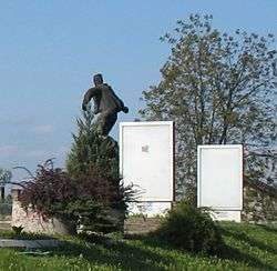
Monument to the Partisans | |||
| |||
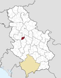 Location of the municipality of Ljig within Serbia | |||
| Coordinates: 44°13′N 20°11′E / 44.217°N 20.183°ECoordinates: 44°13′N 20°11′E / 44.217°N 20.183°E | |||
| Country |
| ||
| District | Kolubara | ||
| Settlements | 27 | ||
| Government | |||
| • Mayor | Miroslav Maksimović (independent) | ||
| Area[1] | |||
| • Municipality | 279 km2 (108 sq mi) | ||
| Population (2011 census)[2] | |||
| • Town | 5,000 | ||
| • Municipality | 12,730 | ||
| Time zone | CET (UTC+1) | ||
| • Summer (DST) | CEST (UTC+2) | ||
| Postal code | 14240 | ||
| Area code | +381 14 | ||
| Car plates | VA | ||
| Website |
www | ||

.png)
Ljig (Serbian Cyrillic: Љиг) is a town of 3,219 inhabitants in central Serbia. It is surrounded by a municipality of the same name, which has a total of 12,730 inhabitants.
Ljig is an underdeveloped region of Serbia, surrounded by Mount Rajac and Mount Rudnik. It was struck by an earthquake in 2003 and a drought in 2004.
Municipality

The town of Ljig is the economic and cultural center of the municipality with a primary school founded in 1907, a high school, a public library with a cinema, a health center and a post office.
The other settlements of Ljig municipality are Ivanovci, Kozelj, Lalinci, Veliševac, Babajić, Ba, Kadina Luka, Kalanjevci, Jajčić, Liplje, Moravci, Stavica, Gukoš, Milavac, Brančić, Poljanice, Latković, Slavkovica, Paležnica, Belanovica, Bošnjanović, Donji Banjani, Dići, Cvetanovac, Živkovci and Šutci.
History
The recorded history of the Ljig settlement itself begins in 1911, when a railroad was built between Lajkovac and Gornji Milanovac. The area, however, has a long history. The Dići church was founded by Serbian nobleman Vlgdrag, who was buried here in 1327.[3] The ruins of the medieval Vavedenje Monastery include impressive sarcophagi dating from the 15th century, believed to belong to the Serbian despots Stefan Branković and Đurađ Branković. According to legend, Djuradj's wife, Jerina, was buried there as well.
An early reference to "Ljig" can be found in the 17th century records of Evliya Çelebi, which describe "LIGmehri" (the Ljig River) rising from Kara Dag in the village Baht (today's Ba) and flowing into the Kolubara River near Valjevo. No settlement in the area was known to the Austrians when they occupied Serbia from 1717 to 1739. By 1818, however, the nearby settlement Gukosi had grown to 50 homes.
A railway station was built in 1917 near the present-day center of Ljig. This lower area under the Gukoši hill includes a small settlement with a municipal court, school, inn, two stores, two textile mills, three tailors and several houses, and when still part of Gukoši had been referred to as the area "on the Ljig River."
During World War I, the Battle of Kolubara was fought nearby, making this area significant in history of Serbia and of war, and in military science. A monument memorializing the battle has been erected on Rajac Mountain.
Ljig separated from Gukoši in 1922, and by 1930 a school, health center and church were built. Prior to that time, Ljig residents had worshipped in Moravci.
References
| Wikimedia Commons has media related to Ljig. |
- ^ "Plum brandy, the Internet and the world", European Agency for Reconstruction press release on Ljig
- ^ 2002 Serbian National Census
- ↑ "Municipalities of Serbia, 2006". Statistical Office of Serbia. Retrieved 2010-11-28.
- ↑ "2011 Census of Population, Households and Dwellings in the Republic of Serbia: Comparative Overview of the Number of Population in 1948, 1953, 1961, 1971, 1981, 1991, 2002 and 2011, Data by settlements" (PDF). Statistical Office of Republic Of Serbia, Belgrade. 2014. ISBN 978-86-6161-109-4. Retrieved 2014-06-27.
- ↑ Stamenković, Srboljub Đ. (2002). Geografska enciklopedija: naselja Srbije. Geografski fakultet. p. 499.