Otis, Massachusetts
| Otis, Massachusetts | ||
|---|---|---|
| Town | ||
|
Benton Pond, East Otis | ||
| ||
 Location in Berkshire County and the state of Massachusetts. | ||
| Coordinates: 42°11′35″N 73°05′32″W / 42.19306°N 73.09222°WCoordinates: 42°11′35″N 73°05′32″W / 42.19306°N 73.09222°W | ||
| Country | United States | |
| State | Massachusetts | |
| County | Berkshire | |
| Settled | 1735 | |
| Incorporated (as Loudon) | 1773 | |
| Incorporated (as Otis) | June 13, 1810 | |
| Government | ||
| • Type | Open town meeting | |
| Area | ||
| • Total | 38.0 sq mi (98.5 km2) | |
| • Land | 35.6 sq mi (92.1 km2) | |
| • Water | 2.5 sq mi (6.5 km2) | |
| Elevation | 1,220 ft (372 m) | |
| Population (2010) | ||
| • Total | 1,612 | |
| • Density | 45/sq mi (17.5/km2) | |
| Time zone | Eastern (UTC-5) | |
| • Summer (DST) | Eastern (UTC-4) | |
| ZIP code | 01253 | |
| Area code(s) | 413 | |
| FIPS code | 25-51580 | |
| GNIS feature ID | 0619422 | |
| Website |
www | |


Otis is a town in Berkshire County, Massachusetts, United States. It is part of the Pittsfield, Massachusetts Metropolitan Statistical Area. The population was 1,612 at the 2010 census.[1]
For geographic and demographic information on East Otis, which is part of the town of Otis, see East Otis, Massachusetts. The numbers reported in that article are included in the figures below.
History
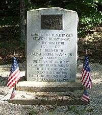
Officially incorporated in 1810, the town was created when the unincorporated town of Loudon annexed the adjacent District of Bethlehem in 1809.[2] It was named after Harrison Gray Otis, an influential lawyer, financier, and politician in revolutionary Massachusetts. General Henry Knox passed through the town in January 1776, bringing cannons from Fort Ticonderoga in New York to aid in ending the Siege of Boston, a route now known as the Knox Trail. The town was a farming community, with several small mill industries growing along the waterways, and today is mostly rural with some tourism.
Geography
According to the United States Census Bureau, the town has a total area of 38.0 square miles (98.5 km2), of which 35.6 square miles (92.1 km2) is land and 2.5 square miles (6.5 km2), or 6.55%, is water.[1] Otis lies along the eastern border of Berkshire County with Hampden County, bordered by Becket to the north, Blandford to the east, Tolland to the southeast, Sandisfield to the south, and Monterey and Tyringham to the west. Otis is 23 miles (37 km) southeast of Pittsfield, 30 miles (48 km) west-northwest of Springfield, and 116 miles (187 km) west of Boston.
Otis lies in the southern end of the Berkshire Mountains, and is dotted by several hills. The West Branch of the Farmington River rises in the town, heading southward towards the Connecticut River. The southeastern part of town is dominated by the Otis Reservoir and Big Pond, as well as portions of Tolland State Forest and Otis State Forest. The highest points in the town are to the north, with Church Hill to the east and Kingsbury Mountain to the west. Much of the land around the brooks of town is marshy. Just west of the town center is Otis Ridge Ski Area. Most of the population is around the reservoir and the center of town.
Otis lies at the intersection of Massachusetts Route 8 and Route 23. Route 8 was once part of the New England interstate system, as the Stratford-Waterbury-North Adams Route. Route 23 is known as the Knox Trail, with a historical marker along the route in the eastern part of town. Interstate 90 (the Massachusetts Turnpike) passes through the northern edge of town twice, with the nearest exit being in Lee. There is no rail, bus or air service in town, with the nearest being in Pittsfield and Westfield. The nearest national air service is at Bradley International Airport in Windsor Locks, Connecticut.
Demographics
| Historical population | ||
|---|---|---|
| Year | Pop. | ±% |
| 1850 | 1,224 | — |
| 1860 | 998 | −18.5% |
| 1870 | 960 | −3.8% |
| 1880 | 785 | −18.2% |
| 1890 | 583 | −25.7% |
| 1900 | 476 | −18.4% |
| 1910 | 494 | +3.8% |
| 1920 | 361 | −26.9% |
| 1930 | 367 | +1.7% |
| 1940 | 364 | −0.8% |
| 1950 | 359 | −1.4% |
| 1960 | 473 | +31.8% |
| 1970 | 820 | +73.4% |
| 1980 | 963 | +17.4% |
| 1990 | 1,073 | +11.4% |
| 2000 | 1,365 | +27.2% |
| 2010 | 1,612 | +18.1% |
| * = population estimate. Source: United States Census records and Population Estimates Program data.[3][4][5][6][7][8][9][10][11][12] | ||

As of the census[13] of 2000, there were 1,365 people, 567 households, and 386 families residing in the town. By population, Otis ranks 19th out of the 32 cities and towns in Berkshire County, and 312nd out of 351 cities and towns in Massachusetts. The population density was 38.1 people per square mile (14.7/km²), which ranks it 18th in the county and 312th in the Commonwealth. There were 1,572 housing units at an average density of 43.9 per square mile (16.9/km²). The racial makeup of the town was 96.56% White, 0.59% African American, 0.29% Native American, 0.88% Asian, 0.37% from other races, and 1.32% from two or more races. Hispanic or Latino of any race were 0.29% of the population.
There were 567 households out of which 26.6% had children under the age of 18 living with them, 59.1% were married couples living together, 5.5% had a female householder with no husband present, and 31.9% were non-families. 24.3% of all households were made up of individuals and 7.6% had someone living alone who was 65 years of age or older. The average household size was 2.40 and the average family size was 2.90.
In the town the population was spread out with 21.8% under the age of 18, 5.7% from 18 to 24, 28.1% from 25 to 44, 30.3% from 45 to 64, and 14.1% who were 65 years of age or older. The median age was 42 years. For every 100 females there were 111.6 males. For every 100 females age 18 and over, there were 108.2 males.
The median income for a household in the town was $51,488, and the median income for a family was $55,455. Males had a median income of $41,065 versus $30,179 for females. The per capita income for the town was $25,029. About 4.6% of families and 7.4% of the population were below the poverty line, including 11.4% of those under age 18 and 4.2% of those age 65 or over.
Government
Otis uses the open town meeting form of government, and is led by a board of selectmen and an administrative assistant. The current Board of Selectmen consists of Roberta Sarnacki, Donald Hawley, and Brian Crandall.[14] All four of the town's main offices, including the town hall, police and fire departments and the town library, are located at the center of town, as is the central post office. A second post office is located in East Otis. The library is a part of the regional library systems. The nearest hospital, Noble Hospital, is 20 miles (32 km) away in Westfield.
On the state level, Otis is represented in the Massachusetts House of Representatives by the Fourth Berkshire district, which covers southern Berkshire County, as well as the westernmost towns in Hampden County. In the Massachusetts Senate, the town is represented by the Berkshire, Hampshire and Franklin district, which includes all of Berkshire County and western Hampshire and Franklin counties.[15] The town is patrolled by the Otis Police Department, as well as the First (Lee) Station of Barracks "B" of the Massachusetts State Police. Roberta Sarnacki serves as the Chief of Police and Director of Emergency Management for the town. G. Sandy Pinkham serves as the Fire Chief.[16] [17]
On the national level, Otis is represented in the United States House of Representatives as part of Massachusetts's 1st congressional district, and has been represented by Richard Neal of Springfield, Massachusetts since January, 2013. Massachusetts is currently represented in the United States Senate by senior senator Elizabeth Warren and junior senator Ed Markey.
Education
Otis, along with neighboring Sandisfield, Tolland and Becket, is part of the Farmington River Regional School District. The district's only school, Farmington River Elementary School, houses students from pre-kindergarten through sixth grades. For the upper grades, most students attend either (1) Great Barrington-based Monument Valley Regional Middle School and Monument Mountain Regional High School or (2) Lee Middle/High School. Proximity to private schools located in Lenox, Great Barrington, or Westfield allow alternatives to public school.
The nearest community college is Berkshire Community College in Pittsfield and Great Barrington. The nearest state college is Westfield State University. The nearest private college is Bard College at Simon's Rock in Great Barrington, with other private colleges in Springfield.
References
| Wikimedia Commons has media related to Otis, Massachusetts. |
- 1 2 "Geographic Identifiers: 2010 Demographic Profile Data (G001): Otis town, Berkshire County, Massachusetts". U.S. Census Bureau, American Factfinder. Retrieved December 16, 2013.
- ↑ "A history of the county of Berkshire, Massachusetts, in two parts, the first being a general view of the county, the second, an account of the several towns".
In June, 1809, the district of Bethlehem was united with the town of Loudon...
- ↑ "TOTAL POPULATION (P1), 2010 Census Summary File 1". American FactFinder, All County Subdivisions within Massachusetts. United States Census Bureau. 2010.
- ↑ "Massachusetts by Place and County Subdivision - GCT-T1. Population Estimates". United States Census Bureau. Retrieved July 12, 2011.
- ↑ "1990 Census of Population, General Population Characteristics: Massachusetts" (PDF). US Census Bureau. December 1990. Table 76: General Characteristics of Persons, Households, and Families: 1990. 1990 CP-1-23. Retrieved July 12, 2011.
- ↑ "1980 Census of the Population, Number of Inhabitants: Massachusetts" (PDF). US Census Bureau. December 1981. Table 4. Populations of County Subdivisions: 1960 to 1980. PC80-1-A23. Retrieved July 12, 2011.
- ↑ "1950 Census of Population" (PDF). Bureau of the Census. 1952. Section 6, Pages 21-10 and 21-11, Massachusetts Table 6. Population of Counties by Minor Civil Divisions: 1930 to 1950. Retrieved July 12, 2011.
- ↑ "1920 Census of Population" (PDF). Bureau of the Census. Number of Inhabitants, by Counties and Minor Civil Divisions. Pages 21-5 through 21-7. Massachusetts Table 2. Population of Counties by Minor Civil Divisions: 1920, 1910, and 1920. Retrieved July 12, 2011.
- ↑ "1890 Census of the Population" (PDF). Department of the Interior, Census Office. Pages 179 through 182. Massachusetts Table 5. Population of States and Territories by Minor Civil Divisions: 1880 and 1890. Retrieved July 12, 2011.
- ↑ "1870 Census of the Population" (PDF). Department of the Interior, Census Office. 1872. Pages 217 through 220. Table IX. Population of Minor Civil Divisions, &c. Massachusetts. Retrieved July 12, 2011.
- ↑ "1860 Census" (PDF). Department of the Interior, Census Office. 1864. Pages 220 through 226. State of Massachusetts Table No. 3. Populations of Cities, Towns, &c. Retrieved July 12, 2011.
- ↑ "1850 Census" (PDF). Department of the Interior, Census Office. 1854. Pages 338 through 393. Populations of Cities, Towns, &c. Retrieved July 12, 2011.
- ↑ "American FactFinder". United States Census Bureau. Retrieved 2008-01-31.
- ↑ http://www.townofotisma.com
- ↑ Senators and Representatives by City and Town
- ↑ Station B-1, SP Lee
- ↑ https://sites.google.com/site/otismapolicedepartment/
External links
Municipalities and communities of Berkshire County, Massachusetts, United States | ||
|---|---|---|
| Cities | 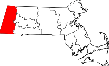 | |
| Towns | ||
| CDPs | ||
| Other villages | ||