Massachusetts Turnpike
| ||||
|---|---|---|---|---|
 | ||||
| Route information | ||||
| Maintained by MassDOT | ||||
| Length: | 138.10 mi[1] (222.25 km) | |||
| Existed: | 1958 – present | |||
| History: | Final construction in 2003 | |||
| Major junctions | ||||
| West end: |
| |||
| East end: |
| |||
| Highway system | ||||
| ||||
|
| ||||

The Massachusetts Turnpike (commonly called the Mass Pike or the Pike)[2] is the easternmost 138-mile (222 km) stretch of Interstate 90. Beginning at the eastern border of Boston and connecting with the Berkshire Connector portion of the New York State Thruway, the Turnpike traverses the state and serves the major cities of Springfield and Worcester.
The Massachusetts Turnpike is a toll road with travel between most, but not all, exits requiring payment. The Fast Lane electronic toll collection system was introduced as a method of toll collection alongside cash payment in 1998; it was later folded into the E-ZPass branding in 2012. The original toll booths were demolished and replaced by toll gantries with the transition to open road tolling in October 2016, which eliminated cash payment in favor of E-ZPass transponders and "pay-by-plate" billing.
Route description
The Massachusetts Turnpike is the major east-west highway in Massachusetts, connecting three of its major cities: Springfield, Worcester, and Boston. It is also the easternmost portion of Interstate 90. The roadway begins at the New York border and continues in a south-easterly direction until the junction with Interstate 84 in Sturbridge; from that point it continues in a north-easterly direction into Boston. The roadway terminates in East Boston at Route 1A, just outside Logan International Airport.
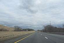
Between the New York border and the I-84 junction, the roadway is a four-lane divided highway, two lanes in either direction. Between I-84 and exit 17 in Newton, it is a six-lane divided highway which grows to eight lanes between the Newton and Copley exits where it drops back to six lanes. It stays as a six lane roadway until the Ted Williams Tunnel where it drops back to four lanes until the exit of the tunnel in East Boston.
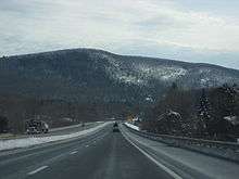
The highest point on the Turnpike is in the Town of Becket in the Berkshire Hills, at elevation 1,724 feet (525 m) above sea level; this is also the highest point on Interstate 90 east of South Dakota.[3]
History
Pre-Interstate designation

Plans for the Turnpike date back to at least 1948, when the Western Expressway was being planned. The original section would have connected Boston's then-proposed Inner Belt to Newton with connections with US 20 and Route 30 for traffic continuing west. Later extensions would take the road to and beyond Worcester. From the beginning, the corridor was included in federal plans for the Interstate Highway System, stretching west to the New York state line and beyond to Albany.
Also included in the route was the planned Springfield Bypass, which had been proposed to provide a bypass of US 20 in the Springfield area. Part of this route (and that of the eventual Turnpike) used the grading from the never-opened Hampden Railroad. Similarly, the West Stockbridge Bypass provided a new route of Route 102 from Route 183 in Stockbridge west to Route 102 just east of the state line in West Stockbridge; this latter route was built prior to the Turnpike.
The Massachusetts Turnpike Authority was created in 1952 by a special act of the Massachusetts General Court (legislature) upon the recommendation of Governor Dever and his Commissioner of Public Works, William F. Callahan. (1952 Acts and Resolves chapter 354; 1952 Senate Doc. 1.) The enabling act was modeled upon that of the Mystic River Bridge Authority (1946 Acts and Resolves chapter 562), but several changes were made that would prove of great importance fifty years later. Callahan served as chairman of the Authority until his death in April 1964.
Construction began in 1955, and the whole four-lane road from Route 102 at the state line to Route 128 (now also Interstate 95 in Weston) opened on May 15, 1957. The Berkshire Thruway opened on May 26, 1959, connecting the west end to the New York State Thruway mainline south of Albany. Prior to its opening, traffic used Route 22 and US 20 in New York. At the Massachusetts/New York state line, one can see where the Turnpike made an abrupt right turn before terminating at Route 102, as the old pavement still exists for Turnpike Authority and State Police vehicles to access this remote stretch of highway.[5]
After political and legal battles related to the Boston Extension inside Route 128, construction began on March 5, 1962, with the chosen alignment running next to the Boston and Albany Railroad and reducing that line from four to two tracks. In September 1964 the part from Route 128 east to exit 18 (Allston) opened, and the rest was finished on February 18, 1965, taking it to the Central Artery.
Post-Interstate designation and Big Dig construction

The Interstate 90 designation was assigned to the Turnpike in 1959 with the completion of plans for the Interstate Highway System. Early proposals took I-90 across the northern part of the state, along Route 2, but this was rejected as too costly. With the completion of the Boston Extension, that too was designated as I-90.
In the 1990s, then-Governor William Weld took the decision to turn over the assets of Boston's Big Dig project to the Turnpike Authority.[6][7][8] During this time he appointed James Kerasiotes to the Turnpike Authority to continue the authority's oversight of the Big Dig project.[9]
In 1991, construction began on the extension of the Massachusetts Turnpike to Logan Airport, via the Ted Williams Tunnel as part of the Big Dig interstate/tunnel project. The final extension opened in 2003; the eastern end of I-90 now merges into Route 1A.
The legislature separated the Turnpike into a western portion, from the New York border to Interstate 95, and the eastern Metropolitan Highway System, which includes a 15-mile (24 km) stretch of the Turnpike from Interstate 95 to East Boston, the Ted Williams, Sumner, and Callahan tunnels under Boston Harbor, and I-93 from Southampton Street through the Thomas P. "Tip" O'Neill tunnel and the Leonard P. Zakim Bridge to the foot of the Tobin Bridge.[10] Finances for the two parts of the Turnpike are accounted for separately.
| Wikinews has related news: Portion of ceiling collapses in Boston tunnel |
In response to a fatality caused by the collapse of the ceiling of the eastbound I-90 connector tunnel approaching the Ted Williams Tunnel on July 10, 2006, and in response to Amorello's refusal (at the time) to resign, Romney took legal steps to have Amorello forcibly removed as head of the Massachusetts Turnpike Authority,[11] culminating in Amorello's resignation on August 15, 2006. The next day, John Cogliano was sworn in as the new Chairman of the Turnpike Authority by Romney.[12]
On November 27, 2006, departing Attorney General Tom Reilly (Democrat) announced the state will launch a civil suit over the collapse of the ceiling in the Ted Williams Tunnel. The Commonwealth will be seeking over $150 million from project manager Bechtel/Parsons Brinckerhoff, builder Modern Continental Construction Co. and the manufacturer of the epoxy used to hold the ceiling bolts.[13][14][15][16]
Administrative conflicts
Since 2001, the Turnpike Authority had come under fire from state politicians in a fight for control of the quasi-state agency. Beginning in 2001, former Massachusetts acting Governor Jane Swift (Republican) attempted to fire Christy Mihos, a former Turnpike board member and Jordan Levy, the current Vice Chairman of the board.
Mihos and Levy had cast votes on the board to postpone a toll hike. Swift objected, saying such a delay was "fiscally irresponsible" and saying the two men "interfered with the effective daily management of the Authority."[17] Mihos and Levy refused to step down and sued Swift to retain their positions. The Massachusetts Supreme Judicial Court (SJC) ruled that the Turnpike was "not part of the machinery of the government" and therefore not subject to Swift's decisions.[18]
Governor Mitt Romney, elected in 2002 during a fiscal crisis, ran on a political platform of streamlining state government and eliminating waste. Part of this was the elimination of the Turnpike Authority. Romney wanted to fold the Turnpike into MassHighway, the state highway department, operated under the Executive Office of Transportation. A first step to this was to replace the Chairman of the Board, Matthew J. Amorello with someone loyal to the Governor. The Governor has the power to appoint members to the board, but the Massachusetts Supreme Judicial Court (SJC) advised in an advisory opinion that "nothing in G. L. c. 81A explicitly provides for the removal and reassignment of the chairperson to the position of "member."[19][20]
Romney put pressure on Amorello to step down. Amorello announced he would do so in 2007, after Romney would have left office. Romney continued to press the legislature to give him the power to remove members from the board, specifically the chairman, pointing to a series of financial and construction mishaps over the last several years. However, the legislature instead sought to keep Amorello on board by extending the terms of various board members to prevent Romney from removing Amorello.[21]
Folding into MassDOT
At a January 22, 2009, board meeting, the Turnpike decided to stop charging a one-time $25.95 fee for the acquisition of a Fast Lane toll transponder, replacing it with a 50-cent monthly recurring service fee.[22] The implementation of the 50-cent monthly fee was canceled after long delays at toll plazas on Easter Sunday.[23][24]
Under a plan to save state funds, the Massachusetts Registry of Motor Vehicles (RMV) announced plans to close eleven of its branches in leased locations and move the operations into facilities owned by MassHighway and the Massachusetts Turnpike Authority located in toll plazas, visitor centers, and offices. RMV branch closings were planned for Framingham, Lowell, North Attleboro, Cambridgeside Galleria Mall in Cambridge, New Bedford, Eastfield Mall in Springfield, Southbridge, Falmouth, Eastham, Beverly, and Boston.[25] Also, a portion of the newly increased sales tax in the state averted a planned toll increase. The MTA will receive approximately $100 million from the state general fund over the next few years, alleviating the need for the toll hike.[26]
Under legislation signed into law by Gov. Deval Patrick on June 26, 2009, the turnpike was folded into a new super-agency that controls all surface transportation in the state. The new agency, the Massachusetts Department of Transportation (MassDOT), operates all highways formerly under MassHighway and the Turnpike Authority as well as eight urban roadways formerly owned and maintained by the state Department of Conservation and Recreation (DCR).[27] In addition, MassDOT oversees the RMV, MBTA, regional transit authorities, and the state aeronautics commission.[28] The new Transportation Department began operations on November 1, 2009.[29] According to MTA board member Mary Z. Connaughton's blog entry for the Boston Herald, all of the pilgrim-hat signage unique to the Turnpike will be eliminated.[30] However, in a personal correspondence with AARoads.com's road blog, a MassDOT official said that usage of the hat would actually increase. When guide signs on Interstates 95 and 495 are replaced, the current "MassPike" signage will be replaced with pilgrim hat shields.[31]
The Turnpike Authority also owned the Callahan Tunnel and Sumner Tunnel, the other two road connections between downtown Boston and East Boston under Boston Harbor.[32] Upon completion of the Central Artery/Tunnel Project, all tunnels constructed as part of the Big Dig, including the O'Neill Tunnel segment of I-93, were transferred to its control.[33] The Authority received no state or federal government funding. Its revenues came from tolls, leases on air rights and service areas, and advertising. Its assets were all transferred to the new MassDOT agency as part of the restructuring of agencies.[34]
Future
Allston straightening
Future plans call for the re-routing of the highway over the former Beacon Park Yard, in order to free up space and make the highway safer.[35] As of July 2016, the project hopes to break ground in 2019.[36]
Proposed exits
There have been proposals to add exits in Becket, Blandford, Warren, and Oxford since the removal of the toll booths. There is a 30-mile (48 km) gap between exit 2 (Lee) and exit 3 (Westfield)—the longest gap between exits on the entire Pike—and a 17-mile (27 km) gap between exit 8 (Palmer) and exit 9 (Sturbridge). If a car misses the exit, it is an hour to return. If those exits were built, the distance from Blandford to Westfield would be 11 miles (18 km) and the distance from Lee to Becket would be 7 miles (11 km). The Warren exit would cut the distance in half.
Tolls

The Massachusetts Turnpike is a toll road; the 2009 reform law requires tolls collected on the Western Turnpike be spent there, and those collected on the Metropolitan Highway System must be spent there.[37] After protests from Western Massachusetts residents that their toll money was funding the Big Dig, a Boston highway project, tolls were removed on a western portion of the freeway in July 1996: no toll was charged for passenger-vehicle travel between Springfield (Exit 6, Interstate 291) and the New York (Exit 1, West Stockbridge) border in either direction.
Toll removal controversy
On October 18, 2006, the Turnpike board voted to remove all tolls west of the Route 128 Toll Plaza in response to a recommendation made by Eric Kriss,[38] a former fiscal adviser to Romney, in which he had been asked to review the Turnpike situation following the July 2006 tunnel ceiling collapse.[39]
On October 19, 2006, members of the Massachusetts Legislature Transportation Committee were quoted in The Boston Globe as saying that the Governor's actions may require state law to be amended for the toll removal to happen. In addition, questions have been raised in regard to how the State would fund the maintenance of the Turnpike after the removal of the tolls.[40]
The issue of the removal of the tolls is highly charged politically. Several members of the state Democratic Party declared this as a political maneuver to bolster the gubernatorial campaign of Lieutenant Governor Kerry Healey, a Republican, who was behind in the polls at the time of the announcement. Also, because the MTA Board is composed of Romney appointees, Kriss's former association with the Romney administration and the ongoing election at the time, the issue was clouded by accusations of partiality and political agendas from both sides of the aisle.
In the November 9, 2006, edition of The Boston Globe, Romney announced his intention to try to remove the tolls before Governor-elect Deval Patrick, a Democrat, was inaugurated in January 2007, but this did not occur. As of November 2008, Patrick's plan was to remove all tolls west of Interstate 95, except at the West Stockbridge and Sturbridge tolls,[41] but this also did not occur before the end of his term in January 2015. State law requires tolls to be removed west of Route 128 when its debt is paid and the road is in "good condition", but MassDOT plans to continue tolls after the bonds are paid off in January 2017, because the road will still need $135 million per year for repairs and maintenance.[42]
Tolls were reinstated between exit 1 and exit 6 in October 2013 at the same toll rates from 1996. The tolls were reinstated because of a Massachusetts state transportation financing package approved in early 2013.[43]
Previous collection methods

From Exit 1, in West Stockbridge, to Exit 14/15 (I-95 and Route 128), in Weston, the Massachusetts Turnpike is a closed-system toll road, using long-distance tickets obtained once by a motorist on entrance, and surrendered on exit, at toll gates. The toll gates exist at all exits and entrances from Exit 1 to Exit 14/15. From Exit 14/15 to its eastern end in East Boston (in other words, east of the toll barrier residing between Exits 14 and 15), the Massachusetts Turnpike is an open-system toll road. There are toll plazas at Exit 18/19/20 in Allston, in both mainline directions and on the interchange ramps. There also is a toll plaza on the mainline at the westbound entrance to the Ted Williams Tunnel, in East Boston. Exits 16, 17, and 21–26, plus the eastbound-only Route 1A junction have no toll plazas on their ramps. Travel between exits 16 and 17, both in Newton, is a "free movement": no toll is charged for travel between these two exits. At exit 16, traffic can enter the Turnpike only eastbound and may exit from the Turnpike only westbound. Toll plazas on the interchange ramps at Exit 16 were removed in 1996 at the direction of then Governor William Weld.
Motorists can pay tolls to toll-booth personnel or use the E-ZPass (formerly Fast Lane) electronic toll-collection system, whereby transponders installed in the cars (typically on the inner windshields) are recognized automatically in special lanes at toll plazas, the toll amounts then being withdrawn from the motorists' accounts. MassDOT eliminated the name Fast Lane, and begin using the E-ZPass brand name for the ETS system since mid-2012, shortly after the Citizens Bank sponsorship contract expired.[44][45][46] All signage at toll plazas was changed to the standard white-on-purple E-ZPass signs.[45]
In September 2012, MassDOT introduced prepaid E-ZPass transponders called E-ZPass "On-the-Go".[47]
Open road tolling
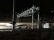
In 2014, Raytheon won a $130 million contract to convert the Massachusetts Turnpike to all-electronic open road tolling.[48] The stated goal of the change was to "make vehicle travel safer and more efficient".[49] Additional changes include the elimination of toll booths and toll booth operators, as well as the demolition of existing toll plazas and reconfiguration of surrounding roadways.[42][50][51] Overhead gantries between most exits will read EZPass transponders. Drivers without a transponder will "pay-by-plate", having their license plate photographed and an invoice sent to the registered owner. This method of payment adds a $3 surcharge per toll transaction, with payment made online, or in cash at a local retail location with an additional $2.95 fee.[52][53] Installation of gantries began in January 2016; the "Go-Live" date was October 28, 2016.[50] The inner segments of toll booths will be demolished in the 30 days after this date, allowing traffic speeds to be raised. Complete demolition of toll booths and reconstruction is expected by the end of 2017,[50] except for the Sumner Tunnel.[54]
Toll gantries have been constructed at:[50]
- Lee (mile 10.01)
- Blandford (mile 26.25)
- Westfield (mile 40.86)
- Ludlow (mile 57.68)
- Warren (mile 69.78)
- Charlton (mile 89.10)
- Hopkinton (mile 104.86)
- Southborough (mile 109.07)
- Framingham (mile 113.92)
- Weston (mile 120.21)
- Newton (mile 126.18)
- Brighton (mile 130.04)
- Allston (mile 131.15)
- Ted Williams Tunnel (East Boston entrance)
As there are no gantries between exits 4 and 7, or between exits 10 and 11, the Massachusetts Turnpike will essentially be free between those pairs of exits. Otherwise the plans are for the transition to open road tolling to be revenue neutral, meaning the tolls between any other pair of exits will only see small adjustments. Tolls will be slightly higher for out-of-state residents without an EZPassMA transponder, and no-transponder tolls will be higher still.[55]
When all-electronic tolling went live on the Mass Pike, the Tobin Bridge, Callahan Tunnel, Sumner Tunnel, and Ted Williams Tunnel joined the system and were converted to charging a single toll in both directions, rather than a double toll in one direction. The Tobin Bridge was converted to all-electronic tolling for southbound only in July 2014.[50]
In addition to license plate information, the gantries also collect vehicle speed data, which a MassDOT spokesperson said "will not be using the AET system to issue speeding violations".[56] Toll data is not a "public record" which must be disclosed by Freedom of Information Act requests, and MassDOT "All data collected will remain secure and kept confidential."[50] Toll data can be obtained by subpeona, and law enforcement will be able to specify license plate numbers that will generate an immediate email if detected by the system.[57]
Cost
It costs $7.10 for a Class 1 passenger vehicle to travel east from Exit 1 (Route 41), in West Stockbridge, to Logan Airport, in East Boston.[58] Additionally, a flat-rate toll barrier for the Ted Williams Tunnel exists on the westbound side of the turnpike between exits 26 and 25, imposing a $3.50 charge for Class 1 passenger vehicles. Therefore, motorists who are destined to travel away from Logan International Airport via I-90 West will be assessed a $3.50 additional charge, since the only interchange east of this toll barrier other than the eastern terminus at Route 1A is Exit 26, leading into the airport itself.
Service plazas
There are 11 service areas (plazas) on the Massachusetts Turnpike, named for the towns in which they are located. Each plaza offers Gulf gas stations and Gulf Express convenience stores. Most offer McDonald's restaurants, with some plazas having Boston Market and D'Angelo as the main food offerings. Some plazas also have secondary food such as Auntie Anne's pretzels, Ben & Jerry's ice cream, Papa Gino's pizza, Original Pizza, and Fresh City restaurants. Some restaurants at some plazas also offer a drive thru.
The plazas are:[59]
- Lee Plaza between exits 1 and 2
- Blandford Plaza between exits 2 and 3
- Ludlow Plaza between exits 7 and 8
- Charlton Plaza between exits 9 and 10
- Westborough Plaza between exits 11A and 11 (westbound only)
- Framingham Plaza between exits 13 and 12 (westbound only)
- Natick Plaza between exits 13 and 14 (eastbound only)
All service areas except for the westbound Lee Plaza and the eastbound Blandford Plaza feature dog walk areas. All service areas except the westbound Lee, the Blandford, and the Ludlow Plazas offer special family restrooms.
Air rights

The MTA has leased much of the air space over the highway east of Exit 15; these are the structures that have been constructed or are planned:[60]
- The Shaw's Supermarket between exits 16 and 17.
- The Crowne Plaza and Gateway Office complex in Newton Corner at exit 17.
- The Copley Place Mall at exit 22 (1984).
- The new One Beacon development at parcel 9, between Beacon St. and Brookline Ave., including a 23-story apartment complex and mixed use development.[61]
- New construction on parcels 8, and 10 adjacent to Fenway Park (2008–2018).
- Near BU Bridge, Boston University announced long-term plans to extend its campus over the highway.[62]
There is one major air rights property that the MTA does not own and that is the Prudential Center Complex constructed beginning in 1965. This property includes a Shaw's Supermarket, the Prudential Tower office and residential buildings, the Shops at Prudential Center mall, the Hynes Convention Center, and the Back Bay MBTA station.
In 2001, the Turnpike Authority and the City of Boston agreed on guidelines for air rights development for the remaining parcels over the highway in Boston from the I-93 interchange to Commonwealth Avenue (with the exception of a parcel adjacent to the historic Fenway Studios).[63] While development is not presently planned for all of this corridor, the agreement provides de facto zoning rules should it take place.
Exit list
The Mass Turnpike uses a system of sequentially numbered interchanges. Every interaction with the highway is numbered and named, regardless of whether an exit is available or not. All interchanges may be renumbered to mileage-based numbers with a two sign replacement projects scheduled for 2016 to 2018, however, the project contractors were told in May 2016 that they may be asked to put up the new signs with the existing numbers.[64][65]
| County | Location[66] | mi[66] | km | Exit[67] | Destinations[67] | Notes |
|---|---|---|---|---|---|---|
| Berkshire | West Stockbridge | 0.000 | 0.000 | – | Continuation from New York | |
| 2.736 | 4.403 | 1 | Westbound exit and eastbound entrance | |||
| 2.9 | 4.7 | West Stockbridge Toll Plaza (in process of demolition) | ||||
| Lee | 8.5 | 13.7 | Lee Service Plaza | |||
| 10.01 | 16.11 | Electronic Toll Gantry | ||||
| 10.592 | 17.046 | 2 | ||||
| Hampden | Blandford | 26.25 | 42.25 | Electronic Toll Gantry | ||
| 29.0 | 46.7 | Blandford Service Plaza | ||||
| Westfield | 40.434 | 65.072 | 3 | |||
| 40.86 | 65.76 | Electronic Toll Gantry | ||||
| West Springfield | 45.740 | 73.611 | 4 | Exit 14 on I-91 | ||
| 46.293 | 74.501 | Connecticut River | ||||
| Chicopee | 49.041 | 78.924 | 5 | Also serves Westover ARB and Westover Airport[68] | ||
| 51.154 | 82.324 | 6 | Exit 7 on I-291 | |||
| Ludlow | 54.780 | 88.160 | 7 | |||
| 55.6 | 89.5 | Ludlow Service Plaza | ||||
| 57.68 | 92.83 | Electronic Toll Gantry | ||||
| Palmer | 62.641 | 100.811 | 8 | Ware only appears on eastbound signage; Amherst appears on westbound signage | ||
| Worcester | Warren | 69.78 | 112.30 | Electronic Toll Gantry | ||
| Sturbridge | 78.300 | 126.012 | 9 | Eastern terminus of I-84 | ||
| Charlton | 80.2 | 129.1 | Charlton Service Plaza | |||
| 89.10 | 143.39 | Electronic Toll Gantry | ||||
| Auburn | 90.049 | 144.920 | 10 | Also serves Oxford, Webster, Charlton, and Sturbridge;[69] Exit 7 on I-290 | ||
| Millbury | 93.642 | 150.702 | 10A | Also serves Westborough;[70] Exit 10 on Route 146 | ||
| 96.343 | 155.049 | 11 | ||||
| Westborough | 104.6 | 168.3 | Westborough Service Plaza (westbound only) | |||
| Middlesex | Hopkinton | 104.86 | 168.76 | Electronic Toll Gantry | ||
| 106.236 | 170.970 | 11A | Exit 22 on I-495 | |||
| Southborough | 109.07 | 175.53 | Electronic Toll Gantry | |||
| Framingham | 111.181 | 178.928 | 12 | |||
| 113.92 | 183.34 | Electronic Toll Gantry | ||||
| 114.4 | 184.1 | Framingham Service Plaza (westbound only) | ||||
| 116.600 | 187.650 | 13 | ||||
| Natick | 117.6 | 189.3 | Natick Service Plaza / Fast Lane Service Center (eastbound only) | |||
| Weston | 120.21 | 193.46 | Electronic Toll Gantry | |||
| 122.600 | 197.306 | 14 | Eastbound exit and westbound entrance; Exit 25 on I-95 | |||
| 123.456 | 198.683 | Weston Toll Plaza (in process of demolition) | ||||
| 123.458 | 198.686 | 15 | Westbound exit and eastbound entrance; Exit 25 on I-95 | |||
| Newton | 125.207 | 201.501 | 16 | Westbound exit and eastbound entrance | ||
| 126.18 | 203.07 | Electronic Toll Gantry | ||||
| 127.553 | 205.277 | 17 | Washington Street / Galen Street / Centre Street – Newton, Watertown | |||
| Suffolk | Boston | 130.04 | 209.28 | Electronic Toll Gantry | ||
| 130.991 | 210.810 | 18 | Cambridge Street / Storrow Drive – Brighton, Cambridge | Eastbound left exit and westbound entrance | ||
| 19 | Allston/Brighton Toll Barrier (in process of demolition) | |||||
| 20 | Cambridge Street / Storrow Drive – Brighton, Cambridge | Westbound exit and eastbound entrance | ||||
| 131.15 | 211.07 | Electronic Toll Gantry | ||||
| 132.863 | 213.822 | 21 | Westbound entrance only | |||
| West end of Prudential Tunnel | ||||||
| 133.344 | 214.596 | 22 | Dartmouth Street – Prudential Center, Copley Square | Eastbound exit and westbound entrance | ||
| 133.586 | 214.986 | 22A | Clarendon Street | Westbound entrance only | ||
| East end of Prudential Tunnel | ||||||
| 133.876 | 215.453 | 23 | Arlington Street | Westbound entrance only | ||
| 134.315 | 216.159 | 24A | South Station | Eastbound left exit only | ||
| 24B | Left exit eastbound; no eastbound entrance from I-93 south; Exit 20 on I-93 north; Exit 20B on I-93 south Signed as Exit 24 westbound | |||||
| 24C | ||||||
| Fort Point Tunnel under the Fort Point Channel | ||||||
| 134.773 | 216.896 | 25 | South Boston | Via Summer Street | ||
| Ted Williams Tunnel under Boston Harbor | ||||||
| Electronic Toll Gantry | ||||||
| 137.239 | 220.865 | 26 | ||||
| 138.15 | 222.33 | – | Eastern terminus of I-90 | |||
1.000 mi = 1.609 km; 1.000 km = 0.621 mi
| ||||||
References
- ↑ "State Numbered Routes with Milepoints in District 4" (PDF). Commonwealth of Massachusetts. Retrieved November 4, 2009.
- ↑ "Open Road Toll Structure Now on Mass Pike in Weston". Boston: WBZ-TV. January 4, 2016. Retrieved February 7, 2016.
The first evidence of open road tolling on the Massachusetts Turnpike is now visible to drivers. The All-Electronic Tolling system isn't scheduled to begin on the Pike...
- ↑ Vanhoenacker, Mark (August 18, 2014). "What Does This Beloved Road Sign on the Massachusetts Turnpike Actually Mean?". Slate. Retrieved August 19, 2014.
- ↑ It has been reported variously that the sign was changed due to confusion among motorists who sometimes mistakenly turned in the direction the arrow pointed (right) when attempting to enter the turnpike,Montgomery, M. R. (February 28, 1991). "Redrawing the Native American Image". The Boston Globe. p. 69. Retrieved April 3, 2010.
Too many tourists, non-English readers and reflexive drivers were always turning right, following the politically incorrect arrow to nowhere.
, or that it was the result of a letter campaign describing the signs as offensive to Native Americans.https://news.google.com/newspapers?nid=1917&dat=19891122&id=2XIhAAAAIBAJ&sjid=hYgFAAAAIBAJ&pg=1152,5928057 - ↑ "View".
- ↑ "The real builder of the Big Dig". Retrieved October 4, 2014.
- ↑ "Lessons of Boston's Big Dig". Retrieved October 4, 2014.
- ↑ "Massachusetts Turnpike (I-90)".
- ↑ "A Handy Guide to the Big Dig Screw-Up".
- ↑ "MGL Chapter 81A, Section 3".
- ↑ Lehigh, Scot (July 14, 2006). "Amorello, now adrift". The Boston Globe.
- ↑ "Cogliano Sworn In as New Turnpike Chief". WCVB. August 16, 2006. Retrieved October 27, 2009.
- ↑ Herbst, Svea (November 28, 2006). "Mass. to sue Big Dig firms over tunnel accident". Reuters.
- ↑ Murphy, Sean P.; Andrea Estes (July 11, 2007). "Wide risk, wide blame". The Boston Globe. Retrieved October 9, 2009.
- ↑ Saltzman, Jonathan (November 15, 2008). "Companies to settle for $26m in tunnel collapse". The Boston Globe. Retrieved October 9, 2009.
- ↑ Finucane, Martin (March 27, 2009). "AG settles with final two firms in fatal collapse of Big Dig tunnel". The Boston Globe. Retrieved October 9, 2009.
- ↑ "JORDAN LEVY & another vs. THE ACTING GOVERNOR & another". November 19, 2001. Retrieved July 13, 2007.
- ↑ "JORDAN LEVY & another vs. THE ACTING GOVERNOR & another SJC-08730". May 7, 2002. Retrieved July 2, 2007.
- ↑ "ANSWER OF THE JUSTICES TO THE GOVERNOR.". June 29, 2005. Retrieved July 2, 2007.
- ↑ "REQUEST FOR ADVISORY OPINION, A-108 SJC-09461". June 29, 2005. Retrieved July 2, 2007.
- ↑ Murphy, Sean P. (June 2, 2006). "Budget amendment in Senate would let Amorello keep job". The Boston Globe.
- ↑ Martin Finucane (January 21, 2009). "Fast Lane transponders will be free, but users will see a new fee". The Boston Globe. Retrieved April 3, 2010.
- ↑ Noah Bierman (April 22, 2009). "After Easter snafus, Pike puts toll taker layoffs on hold". The Boston Globe. Retrieved April 3, 2010.
- ↑ "Fast Lane Transponders Are Now Fee Free". WBZ TV. Archived from the original on April 28, 2009. Retrieved August 6, 2009.
- ↑ Riley, David Riley (July 3, 2009). "Registry to close Framingham branch, 10 other locations". The MetroWest Daily News. Retrieved August 1, 2009.
- ↑ "Masspike toll hike scrapped". WWLP. Associated Press. June 29, 2009. Retrieved August 1, 2009.
- ↑ "Chapter 25 of the Acts of 2009". The 186th General Court of The Commonwealth of Massachusetts. Retrieved November 5, 2009.
- ↑ "Governor Patrick signs bill to dramatically reform transportation system". Commonwealth of Massachusetts. June 26, 2009. Retrieved August 1, 2009.
- ↑ "About Us". Commonwealth of Massachusetts. Retrieved November 3, 2009.
- ↑ Connaughton, Mary Z. (July 21, 2009). "Hats off, Governor". Boston Herald. Retrieved August 1, 2009.
- ↑ "Mass Turnpike Authority to be absorbed by new Mass Surface Trans Authority". Retrieved October 4, 2014.
- ↑ http://www.state.ma.us/eot/downloads/planning/dataResources/Jurisdiction-District4.pdf
- ↑ "The Big Dig". Retrieved October 4, 2014.
- ↑ Schworm, Peter (October 16, 2009). "End of the road for Mass. Pike". The Boston Globe. Retrieved November 3, 2009.
- ↑ Rocheleau, Matt (October 23, 2013). "Photos: Conceptual designs of project to straighten Mass. Pike in Allston". Boston Globe. Retrieved July 18, 2014.
- ↑ "Allston I-90 Interchange Improvement Project: Placemaking Output Meeting Notes of June 27, 2016" (PDF). p. 9.
- ↑ http://www.massdot.state.ma.us/portals/0/docs/infoCenter/docs_materials/Budget_Plain_English.rtf
- ↑ "Turnpike Task Force Final Report" (PDF).
- ↑ Mishra, Raja; Mac Daniel (October 19, 2006). "Pike board acts to end tolls west of Route 128". The Boston Globe. Retrieved October 27, 2009.
- ↑ Daniel, Mac (October 10, 2006). "Ending Pike tolls is called illegal". The Boston Globe. Retrieved October 26, 2009.
- ↑ http://www.metrowestdailynews.com/x776439258/Patrick-planning-to-dismantle-Mass-Turnpike
- 1 2 Thompson, Elaine (January 23, 2016). "All-Electronic Tolling Begins Installation on Mass. Pike". Telegram & Gazette. Worcester, MA. Retrieved September 5, 2016.
- ↑ "Western Mass. tolls set to be restored". "The Boston Globe"
- ↑ "E-ZPass purple coming to Massachusetts Oct 1 2011 - bank ads coming down". Retrieved October 4, 2014.
- 1 2 "Massachusetts E-ZPass signs go up starting next week, FAST LANE signs replaced". Retrieved October 4, 2014.
- ↑ "Toll Plaza Signs: E-ZPass Replaces Fast Lane". MassDOT Blog. Retrieved October 4, 2014.
- ↑ "Prepaid E-ZPass offers alternative for transponders". The Boston Globe
- ↑ Baker, Cynthia (August 13, 2014). "Raytheon Awarded $130 Million to Convert Massachusetts to Electronic Highway Tolling System" (Press release). Raytheon. Retrieved September 5, 2016.
- ↑ Dummies, Gintautas (June 7, 2016). "New Mass. Pike Electronic Tolling: Will There Be Any Cost Savings from Eliminating Toll Plazas?". MassLive. Retrieved August 9, 2016.
- 1 2 3 4 5 6 Highway Division (2016). "All Electronic Tolling". Massachusetts Department of Transportation. Retrieved September 5, 2016.
- ↑ Dummies, Gintautas (July 27, 2016). "New Mass. Pike Toll Rate Structure Expected to Be Released in August". MassLive. Retrieved August 9, 2016.
- ↑ Highway Division (2016). "Pay By Plate MA". Massachusetts Department of Transportation. Retrieved September 5, 2016.
- ↑ McKay, David (July 19, 2016). "'Open Road Tolling Coming Soon: Time to Get an E-ZPass". Chicopee, MA: WWLP-TV. Retrieved August 9, 2016.
- ↑ Highway Division (August 22, 2016). "All Electronic Tolling: Toll Plaza Demolition and Roadway Reconstruction" (PDF). Massachusetts Department of Transportation. Retrieved September 5, 2016.
- ↑ Rocheleau, Matt (August 22, 2016). "How Much Will Your New Mass. Pike Toll Be?". Boston Globe. Retrieved September 5, 2016.
- ↑ Bombard, Noah R. (July 19, 2016). "Yes, Those New Electronic Toll Gantries on the Mass. Pike Are Clocking Your Speed". MassLive. Retrieved August 9, 2016.
- ↑ Matt Rocheleau (August 22, 2016). "New Mass. Gantries Can Send Authorities Alerts". Boston Globe. Retrieved September 5, 2016.
- ↑ "Toll Calculator". www.massdot.state.ma.us. Retrieved 2016-08-22.
- ↑ "Travel Service Plazas & Tourist Information Centers". Retrieved October 4, 2014.
- ↑ "The Future of Boston". The Boston Globe. Retrieved November 28, 2007.
- ↑ Casey Ross (September 19, 2008). "Developer hopes for a hit at Fenway". The Boston Globe. pp. C1, C6. Retrieved September 20, 2008.
- ↑ The Daily Free Press - BU says campus future is up in the air
- ↑ guidelines for air rights development
- ↑ Malme, Robert H. (2015). "Misc. Massachusetts Highway Photos: MassDOT Exit Renumbering Project 2016". Massachusetts Highways for the 21st Century. Retrieved September 6, 2015.
- ↑ Malme, Robert H. (2016). "New Massachusetts Exit Signage and Milepost Project Update". Sure Why Not. Retrieved June 11, 2016.
- 1 2 MassDOT Planning Division. "Massachusetts Route Log Application". Massachusetts Department of Transportation. Retrieved August 22, 2014.
- 1 2 Massachusetts Department of Transportation. "Exit Numbers and Names: Route I-90 (West Stockbridge to Boston)". MassDOT. Retrieved June 13, 2016.
- ↑ Google (September 2013). "Street View" (Map). Google Maps. Google. Retrieved August 22, 2014.
- ↑ Google (June 2011). "Street View" (Map). Google Maps. Google. Retrieved August 22, 2014.
- ↑ Google (September 2011). "Street View" (Map). Google Maps. Google. Retrieved August 22, 2014.
- Ingraham, Joseph C. "Boston To Chicago; New Section of Thruway Completes Express Route Between Cities Boston To Chicago". The New York Times. May 24, 1959. Resorts Travel section, page XX1.
External links
| Wikimedia Commons has media related to Massachusetts Turnpike. |
- Official Web Site
- The Roads of Metro Boston - Massachusetts Turnpike (I-90)
- Speculative List of Future I-90/Mass Pike Exit Numbers
| Previous state: New York |
Massachusetts | Next state: Terminus |