Lenox, Massachusetts
| Lenox, Massachusetts | ||
|---|---|---|
| Town | ||
|
Town Hall | ||
| ||
 Location in Berkshire County and the state of Massachusetts. | ||
| Coordinates: 42°21′23″N 73°17′07″W / 42.35639°N 73.28528°WCoordinates: 42°21′23″N 73°17′07″W / 42.35639°N 73.28528°W | ||
| Country | United States | |
| State | Massachusetts | |
| County | Berkshire | |
| Settled | 1750 | |
| Incorporated | 1767 | |
| Government | ||
| • Type | Open town meeting | |
| Area | ||
| • Total | 21.7 sq mi (56.1 km2) | |
| • Land | 21.2 sq mi (55.0 km2) | |
| • Water | 0.5 sq mi (1.2 km2) | |
| Elevation | 1,200 ft (366 m) | |
| Population (2010) | ||
| • Total | 5,025 | |
| • Density | 237/sq mi (91.4/km2) | |
| Time zone | Eastern (UTC-5) | |
| • Summer (DST) | Eastern (UTC-4) | |
| ZIP code | 01240 | |
| Area code(s) | 413 | |
| FIPS code | 25-34970 | |
| GNIS feature ID | 0618269 | |
| Website |
www | |


Lenox is a town in Berkshire County, Massachusetts, United States. Set in Western Massachusetts, it is part of the Pittsfield Metropolitan Statistical Area. The population was 5,025 at the 2010 census.[1] Lenox is the site of Tanglewood, summer home of the Boston Symphony Orchestra. Lenox includes the villages of New Lenox and Lenoxdale, and is a tourist destination during the summer.
History

The area was inhabited by Mahicans, Algonquin speakers who largely lived along the Hudson and Housatonic Rivers.[2] Hostilities during the French and Indian Wars discouraged settlement by European colonial settlers until 1750, when Jonathan and Sarah Hinsdale from Hartford, Connecticut, established a small inn and general store. The Province of Massachusetts Bay thereupon auctioned large tracts of land for 10 townships in Berkshire County, set off in 1761 from Hampshire County.
For 2,250 pounds Josiah Dean purchased Lot Number 8, which included present-day Lenox and Richmond. After conflicting land claims were resolved, however, it went to Samuel Brown, Jr., who had bought the land from the Mahican chief, on condition that he pay 650 pounds extra. It was founded as Richmond in 1765. But because the Berkshires divided the town in two, the village of Yokuntown (named for an indigenous chief) was set off as Lenox in 1767. The town was intended to be called Lennox, probably after Charles Lennox, 3rd Duke of Richmond and Lennox (Scottish Gaelic Leamhnachd), but the name was misspelled by a clerk at incorporation.
Early industries included farming, sawmills, textile mills, potash production, glassworks, and quarrying. A vein of iron ore led to the digging of mines under the town, and the establishment by Job Gilbert in the 1780s of an iron works at Lenox Dale, also known as Lenox Furnace. In 1784, Lenox became county seat, which it remained until 1868 when the title passed to Pittsfield. The county courthouse built in 1816 is today the Lenox Library.
The region's rustic beauty helped Lenox develop into an art colony. In 1821, author Catharine Sedgwick moved here, followed by actress Fanny Kemble. Nathaniel Hawthorne and his family came from Salem in 1850,[3] staying a year and a half. Other visitors to the area, including Timothy Dwight, Benjamin Silliman and Henry Ward Beecher, extolled its advantages. After an extension of the Housatonic Railroad arrived in 1838, tourists discovered the town in increasing numbers.
In 1844, Samuel Gray Ward of Boston, the American representative for Barings Bank of London, assembled tracts of land to create the first estate in Lenox. Called Highwood, the Italianate dwelling was designed in 1845 by Richard Upjohn. In 1876, Ward hired Charles F. McKim to design in the Shingle Style another property, Oakwood. The period from 1880 until 1920 would be dubbed the Berkshire Cottage era, when the small New England town was transformed into a Gilded Age resort similar to Newport, Rhode Island, and Bar Harbor, Maine. The wealthy and their entourage opened immense houses for recreation and entertaining during the Berkshire Season, which lasted from late summer until early fall. One event was the annual Tub Parade, when Main Street was lined with ornately decorated carriages. Property values jumped as millionaires competed for land on which to build showplaces. In 1903, an acre in Lenox cost $20,000, when an acre in nearby towns cost a few dollars.
The imposition of the federal income tax in 1913 ended construction of the country mansions in the Berkshires. The estates started to break up during the 1920s. Carnegie's widow sold Shadowbrook to the Jesuits for a seminary in 1922. The Depression made it harder to maintain the estates, and labor was scarce during World War II. After the war, some of the estates were torn or burned down. Others became schools or seminaries. Some estates became preparatory schools, although they would close by the 1970s and 1980s.
The Shadowbrook property is now the Kripalu yoga center; another, The Mount, is the former home of Shakespeare & Company. Some have been converted into vacation condominiums. Tanglewood, the former estate of the Tappan family which lies partially in Stockbridge, would in 1937 become summer home to the Boston Symphony Orchestra. Lenox remains a popular tourist destination. It was a filming location for Before and After (1996) and The Cider House Rules (1999), which was shot at Ventfort Hall.
 Lenox Library c. 1909
 Bellefontaine in 1912
 Curtis Hotel c. 1910
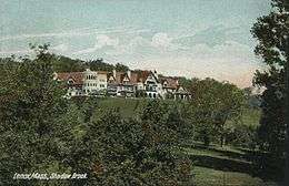 Shadowbrook in 1908
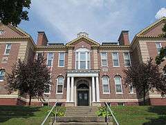 Lenox High School, 1908 building
Geography
According to the United States Census Bureau, the town has a total area of 21.7 square miles (56.1 km2), of which 21.2 square miles (55.0 km2) is land and 0.46 square miles (1.2 km2) is water. Lenox is bordered by Pittsfield to the north, Washington to the east, Lee to the southeast, Stockbridge to the southwest, and Richmond to the west. The town center is 8 miles (13 km) south of downtown Pittsfield, 45 miles (72 km) west-northwest of Springfield, and 125 miles (201 km) west of Boston.
Lenox is set apart from Richmond to the west by a branch of the Berkshire Mountains, with the highest peak in the ridge being Yokun Seat at 2,146 feet (654 m). To the east, October Mountain rises above the Housatonic River, which flows along that side of town and is impeded by a dam that forms Woods Pond. Contamination with PCBs is highest in the section of the River from Pittsfield to Woods Pond.[4] Parts of the Housatonic Valley Wildlife Management Area and October Mountain State Forest line the river's east banks there. Several marshy brooks also feed into the river throughout town. The town is also home to the Pleasant Valley Wildlife Sanctuary south of Yokun Seat, and the Cranwell Resort and Golf Club.
U.S. Routes 7 and 20 meet in the southern end of town, heading north along a bypass road towards Pittsfield. Massachusetts Route 7A, the original path of Route 7, passes through the center of town, with a short distance combined with Massachusetts Route 183, which begins near the start of the bypass road. The town center is 5 miles (8 km) from Exit 2 of the Massachusetts Turnpike (Interstate 90), the nearest interstate highway.
Along the Housatonic, the main rail line between Pittsfield and Great Barrington passes from north to south. Rail service can be found in Pittsfield, and the town is served by the Berkshire Regional Transit Authority (BRTA), with regional service through Pittsfield. Pittsfield is also the site of the nearest regional airport, the Pittsfield Municipal Airport. The town is roughly equidistantly located between the two nearest airports with national flights, Albany International Airport in New York and Bradley International Airport in Connecticut.
Demographics
See also: Lenox (CDP), Massachusetts
| Historical population | ||
|---|---|---|
| Year | Pop. | ±% |
| 1850 | 1,599 | — |
| 1860 | 1,711 | +7.0% |
| 1870 | 1,965 | +14.8% |
| 1880 | 2,043 | +4.0% |
| 1890 | 2,889 | +41.4% |
| 1900 | 2,942 | +1.8% |
| 1910 | 3,060 | +4.0% |
| 1920 | 2,691 | −12.1% |
| 1930 | 2,742 | +1.9% |
| 1940 | 2,884 | +5.2% |
| 1950 | 3,627 | +25.8% |
| 1960 | 4,253 | +17.3% |
| 1970 | 5,804 | +36.5% |
| 1980 | 6,523 | +12.4% |
| 1990 | 5,069 | −22.3% |
| 2000 | 5,077 | +0.2% |
| 2010 | 5,025 | −1.0% |
| * = population estimate. Source: United States Census records and Population Estimates Program data.[5][6][7][8][9][10][11][12][13][14] | ||
As of the census[15] of 2000, there are 5,077 people, 2,212 households, and 1,291 families residing in the town. Lenox ranks eighth out of the 32 cities and towns in Berkshire county by population, and 244th out of the 351 cities and towns in Massachusetts. The population density is 239.3 people per square mile (92.4/km²) ranking 5th in the county and 236th in the Commonwealth. There are 2,713 housing units at an average density of 127.9 per square mile (49.4/km²). The racial makeup of the town is 98.57% White, .30% Black or African American, 0.08% Native American, .02% Asian, 0.04% Pacific Islander, 0.41% from other races, and 0.57% from two or more races. 1.91% of the population are Hispanic or Latino of any race.

There are 2,212 households out of which 22.6% have children under the age of 18 living with them, 49.7% are married couples living together, 6.8% have a female householder with no husband present, and 41.6% are non-families. 36.3% of all households are made up of individuals and 20.8% have someone living alone who is 65 years of age or older. The average household size is 2.17 and the average family size is 2.84.
In the town the population is spread out with 20.8% under the age of 18, 5.1% from 18 to 24, 22.8% from 25 to 44, 26.9% from 45 to 64, and 24.4% who are 65 years of age or older. The median age is 46 years. For every 100 females there are 84.3 males. For every 100 females age 18 and over, there are 79.5 males.
The median income for a household in the town is $65,581, and the median income for a family is $81,413. Males have a median income of $61,226 versus $55,063 for females. The per capita income for the town is $53,263. 4.9% of the population and 3.6% of families are below the poverty line. Out of the total population, 7.3% of those under the age of 18 and 5.8% of those 65 and older are living below the poverty line.
Government

Lenox employs the open town meeting form of government, and is governed by a board of selectmen and a town manager. The town has its own full-time police, fire, ambulance, and public works departments. The Lenox Library, founded in 1856, has occupied the former county courthouse since 1874. It is a member of the regional library network. The nearest hospital, Berkshire Medical Center, is located in Pittsfield.
On the state level, Lenox is represented in the Massachusetts House of Representatives by the Fourth Berkshire district, which covers southern Berkshire County, as well as the westernmost towns in Hampden County. In the Massachusetts Senate, the town is represented by the Berkshire, Hampshire and Franklin district, which includes all of Berkshire County and western Hampshire and Franklin Counties.[16] The town is patrolled by the First (Lee) Station of Barracks "B" of the Massachusetts State Police.[17]
On the national level, Lenox is represented in the United States House of Representatives as part of Massachusetts's 1st congressional district, and has been represented by Richard Neal since January 2013. Massachusetts is currently represented in the United States Senate by senior Senator Elizabeth Warren and junior Senator Ed Markey.
Education
Lenox operates its own school system for the town's 800 students. It is the only town in the county whose schools do not have a formal tuition agreement with any other town (other students may attend, however). Morris Elementary School houses students from pre-kindergarten through fifth grade, and Lenox Memorial Middle and High School houses students through twelfth grade. In 1966 Lenox Memorial High School moved from its 1908 building to a new campus co-located with the town's middle school.[18] The school's athletic teams are called the "Millionaires", in acknowledgement of the town's history, and their colors are maroon and gold. The school's longtime rivals are the Lee Wildcats. Additionally, Lenox is home to two special education schools (Valleycrest School and the Hillcrest Center), as well as private schools, Berkshire Christian, which serves students from pre-kindergarten through grade 8, Berkshire Country Day School, which serves students from pre-kindergarten through ninth grade, and The Montessori School of the Berkshires, which serves toddlers through middle school students.
The nearest community college is Berkshire Community College in Pittsfield. The nearest state colleges are Massachusetts College of Liberal Arts in North Adams, and Westfield State University. The nearest private college is Bard College at Simon's Rock in Great Barrington.
Sites of interest

- Berkshire Scenic Railway Museum
- Church on the Hill
- Frelinghuysen Morris House and Studio
- Kripalu Center
- Lenox Railroad Station
- The Mount (Edith Wharton estate)
- The Museum of the Gilded Age at Ventfort Hall
- Pleasant Valley Wildlife Sanctuary
- Yokun Ridge
- Shakespeare & Company
- Tanglewood
- Ventfort Hall
- Bellefontaine
Notable residents

- Astor family
- Henry Ward Beecher, clergyman and social reformer
- Andrew Carnegie, industrialist
- Giraud Foster, socialite and Industralist
- David Greetham, textual scholar
- Frank T. Hassa, Wisconsin State Assemblyman
- Nathaniel Hawthorne, writer
- Fanny Kemble, actress and writer
- George M. Landers, congressman
- Rose Hawthorne Lathrop, social worker
- Yo-Yo Ma, musician
- Bernadette Mayer, poet
- Nicole Miller, fashion designer
- George Morell, jurist
- Charles Henry Parkhurst, Congregational minister
- John Paterson, general and congressman
- Catharine Sedgwick, writer
- William L. Shirer, journalist and historian
- Maureen Stapleton, actress
- Anson Phelps Stokes, financier
- James Taylor, singer-songwriter and guitarist
- Vanderbilt family
- George Westinghouse, industrialist
- Edith Wharton, writer
- Robert Shaw Sturgis Whitman, Episcopal clergyman
- James Van Der Zee, photographer
- Grenville Lindall Winthrop, art collector and philanthropist
- Mark Zeltser, musician
See also
References
- ↑ "Geographic Identifiers: 2010 Demographic Profile Data (G001): Lenox town, Berkshire County, Massachusetts". U.S. Census Bureau, American Factfinder. Retrieved December 16, 2013.
- ↑ "Native American Life in Massachusetts After European Contact". Lenox History. Retrieved 30 September 2015.
- ↑ Miller, Edwin Haviland. Salem Is My Dwelling Place: A Life of Nathaniel Hawthorne. Iowa City: University of Iowa Press, 1991: 274. ISBN 0-87745-332-2
- ↑ Gay, Frederick. "Distribution of Polychlorinated Biphenyls in the Housatonic River and Adjacent Aquifer, Massachusetts" (PDF). USGS. Retrieved 25 September 2015.
- ↑ "TOTAL POPULATION (P1), 2010 Census Summary File 1". American FactFinder, All County Subdivisions within Massachusetts. United States Census Bureau. 2010.
- ↑ "Massachusetts by Place and County Subdivision - GCT-T1. Population Estimates". United States Census Bureau. Retrieved July 12, 2011.
- ↑ "1990 Census of Population, General Population Characteristics: Massachusetts" (PDF). US Census Bureau. December 1990. Table 76: General Characteristics of Persons, Households, and Families: 1990. 1990 CP-1-23. Retrieved July 12, 2011.
- ↑ "1980 Census of the Population, Number of Inhabitants: Massachusetts" (PDF). US Census Bureau. December 1981. Table 4. Populations of County Subdivisions: 1960 to 1980. PC80-1-A23. Retrieved July 12, 2011.
- ↑ "1950 Census of Population" (PDF). Bureau of the Census. 1952. Section 6, Pages 21-10 and 21-11, Massachusetts Table 6. Population of Counties by Minor Civil Divisions: 1930 to 1950. Retrieved July 12, 2011.
- ↑ "1920 Census of Population" (PDF). Bureau of the Census. Number of Inhabitants, by Counties and Minor Civil Divisions. Pages 21-5 through 21-7. Massachusetts Table 2. Population of Counties by Minor Civil Divisions: 1920, 1910, and 1920. Retrieved July 12, 2011.
- ↑ "1890 Census of the Population" (PDF). Department of the Interior, Census Office. Pages 179 through 182. Massachusetts Table 5. Population of States and Territories by Minor Civil Divisions: 1880 and 1890. Retrieved July 12, 2011.
- ↑ "1870 Census of the Population" (PDF). Department of the Interior, Census Office. 1872. Pages 217 through 220. Table IX. Population of Minor Civil Divisions, &c. Massachusetts. Retrieved July 12, 2011.
- ↑ "1860 Census" (PDF). Department of the Interior, Census Office. 1864. Pages 220 through 226. State of Massachusetts Table No. 3. Populations of Cities, Towns, &c. Retrieved July 12, 2011.
- ↑ "1850 Census" (PDF). Department of the Interior, Census Office. 1854. Pages 338 through 393. Populations of Cities, Towns, &c. Retrieved July 12, 2011.
- ↑ "American FactFinder". United States Census Bureau. Retrieved 2008-01-31.
- ↑ Senators and Representatives by City and Town
- ↑ Station B-1, SP Lee
- ↑ "Lenox Histoey, Lenox Academy". Retrieved August 6, 2016.
External links
| Wikimedia Commons has media related to Lenox, Massachusetts. |
| Wikisource has the text of the 1920 Encyclopedia Americana article Lenox. |
-
 Lenox, Massachusetts travel guide from Wikivoyage
 - Town of Lenox official website
- Lenox Library
- Lenox Chamber of Commerce
- Lenox Caroling Festival
Municipalities and communities of Berkshire County, Massachusetts, United States | ||
|---|---|---|
| Cities | 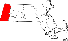 | |
| Towns | ||
| CDPs | ||
| Other villages | ||