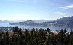
Okanagan

The Okanagan (/oʊkəˈnɑːɡən/ OHK-ə-NAH-gən), also known as the Okanagan Valley and sometimes as the Okanagan Country, is a region in the Canadian province of British Columbia defined by the basin of Okanagan Lake and the Canadian portion of the Okanagan River. It is part of the Okanagan Country, extending into the United States as Okanogan Country. As of 2011, the region's population is approximately 341,818. The primary city is Kelowna. The region is known for its dry, sunny climate, dry landscapes and lakeshore communities and particular lifestyle.[1] The economy is retirement and commercial-recreation based, with outdoor activities such as boating and watersports, snow skiing and hiking. Agriculture has been focused primarily on fruit orchards, with a recent shift in focus to vineyards and wine. The region stretches northwards via the Spallumcheen Valley to connect to Sicamous in the Shuswap Country, and reaches south of the Canada–United States border, where it continues as Okanogan County. The Okanagan as a region is sometimes described as including the Boundary, Similkameen and Shuswap regions, though this is because of proximity and historic and commercial ties with those areas.
Name origin
The name derives from the Okanagan language place name ukʷnaqín.[2] An alternate explanation from Washington proposes "People living where you can see the top", ostensibly of Chopaka Peak in the Lower Similkameen.[3]
History
The Okanagan Valley is home to the Syilx, commonly known as the Okanagan people, an Interior Salish people who live in the valley from the head of Okanagan Lake downstream to near the river's confluence with the Columbia River in present-day Washington, as well as in the neighbouring Similkameen Valley and the Upper Nicola to the north of that, though the whole of their traditional territory encompasses the entire Columbia River watershed and includes areas east of the Okanogan River in Washington, i.e. the Colville Reservation. At the height of Okanagan culture, about 3000 years ago, it is estimated that 12,000 people lived in this valley and surrounding areas. The Okanagan people employed an adaptive strategy, moving within traditional areas throughout the year to fish, hunt, or collect food, while in the winter months, they lived in semi-permanent villages of kekulis, a type of pithouse.[4] Today the member bands of the Okanagan Nation Alliance are sovereign nations, with vibrant natural resource and tourism based economies. Their annual August gathering near Vernon is a celebration of the continuance of Syilx life and culture.
In 1811 the first non-natives came to the Okanagan Valley, in the form of a fur trading expedition voyaging north out of Fort Okanogan, a Pacific Fur Company outpost at the confluence of the Okanogan and Columbia Rivers. Within fifteen years, fur traders established, known as the Brigade Trail via the Cariboo Plateau and Thompson Country to Fort Kamloops and through the Okanagan, from Fort Alexandria at the southern end of the New Caledonia fur district in the Central Interior to the north, to Fort Vancouver, the HBC's headquarters in the Columbia Department, for passing furs between New Caledonia and the Columbia River for shipment to the Pacific. The trade route lasted until 1846, when the Oregon Treaty laid down the border between British North America and the United States west of the Rocky Mountains on the 49th parallel. The new border cut across the valley, bisecting Osoyoos Lake. To avoid paying tariffs, British traders forged a newer route that bypassed Fort Okanogan via the Fraser Canyon from Spuzzum up over the Cascade Mountains, then via the Nicola, Coldwater and Fraser rivers to Fort Langley instead of to Fort Vancouver, which had come into being in American territory. The Okanagan Valley did not see many more outsiders for a decade afterward.
In 1859, the first European settlement was established when Father Charles Pandosy led the making of an Oblate mission at Okanagan Mission, now a neighbourhood of Kelowna. The Fraser Canyon Gold Rush of 1858 eventually encouraged more settlement as some prospectors from the United States took the Okanagan Trail route on their way to the Fraser Canyon, although at the height of the rush the American adventurers who used the route did not settle because of outright hostilities from the Syilx, whom a few of the parties traversing the trail had harassed and brutalized. A few staked claims around the South Okanagan and Similkameen valleys and found gold and copper in places, with another trail from Fort Hope to newer goldfields at Rock Creek and Wild Horse Creek in the East Kootenay, skirting the US border and crossing Osoyoos Lake at Osoyoos, which was a customs post and also the location of the gold commissioner's office. The Dewdney Trail, surveyed and built by Edgar Dewdney, was constructed to prevent trade in the region from going north-south instead of remaining firmly under British control, and also for military mobility purposes should the need arise. In the decades following the gold rushes, ranchers, mostly on military land grants, came to settle on Okanagan Lake; notable ones included the Coldstream Ranch near Vernon, the Ellis Ranch, which formed the basis of the City of Penticton once subdivided, and the Richter Ranch, which continues in operation today, in the mountains between the Town of Oliver and the Village of Keremeos in the Similkameen.
A mining industry began in the southern Okanagan region, with Fairview, now an empty benchland on the western side of Oliver, the best-known and largest of the boomtowns created in the later part of the 19th Century. More farmers, as well as a small service industry, came to meet the needs of the miners.
Fruit production is a hallmark of the Okanagan Valley today, but the industry began with difficulty. Commercial orcharding of apples was first tried there in 1892, but a series of setbacks prevented the major success of commercial fruit crops until the 1920s.
.jpg)
Until the 1930s, the demand for shipping fruit and other goods did drive a need for ongoing operations of the sternwheeler steamboats that serviced Okanagan Lake, operated by a subsidiary of the Canadian Pacific Railway, linking the Southern Mainline with the original transcontinental mainline at Sicamous: the SS Aberdeen from 1886 and then the SS Sicamous and SS Naramata from 1914, and others. The Sicamous and Naramata survive as a tourist attraction on Okanagan Beach on the north side of Penticton, the Sicamous serving both as a museum and also an event facility. Other steamboats operated on Skaha Lake to the south of that city. The club lounge and wheelhouse, without any keel or hull, of the SS Okanagan are in the same park as the Sicamous and Naramata.
While the last half-century has grown several resource-based enterprises in the region, primarily forestry, though mining had played an important role in earlier times. The fastest-growing industries in the Okanagan today are real estate, tourism accommodations and services, and retirement-driven real estate development as well as the ripping up of orchards and their replacement by wineries and vinyards. Favoured by its sunny climate, lakes, and winery attractions, the valley has become a popular destination for vacationers and retirees. The area also attracts seasonal fruit-picking labourers, primarily from Quebec and Mexico.[5][6]
Climate
Like much of Southern British Columbia, the Okanagan receives a mild climate, although the Okanagan is considerably drier than many other areas. It is located roughly between the temperate rainforests of coastal British Columbia, and the world's only temperate forest inland, on the western slopes of the Columbia mountains. Most of the Okanagan lies within the rain shadow of the Cascade Mountains to the southwest. Areas in the north end of the valley receive more precipitation and cooler temperatures than areas to the south. Generally, Kelowna is the transition zone between the drier south and the wetter north. Vegetation also ranges from cactus and sagebrush in the south, to Cedar and Hemlock trees in the North. The Okanagan Valley receives hot summers and moderately cold winters, although the latter are extremely mild by Canadian standards; south of and including the city of Kelowna, no month of the year has an average high temperature that is below freezing (0°C). Areas near Osoyoos and Oliver claim to be Canada's only desert, though they are really shrub-steppe and only semi-arid, and other parts of BC have similar climates and vegetation. Daytime highs in that region occasionally surpass 40 °C in the summer months.
Between 2000BC and 1900AD, the climate and vegetation of the Okanagan had changed little. However, historical records from the Pacific Agrifood Research Station in Summerland indicate that the Okanagan climate had warmed by about 1°C between 1908 and 1994.[7]
Geography

The area was occupied by Pleistocene glaciation, and a widespread mantle of glacial drift covers the underlying bedrock. At the end of the Pleistocene, marginal lakes formed along the sides of the melting ice lobe and streams deposited their loads in them as deltas and accumulations of silt. These accumulations now form the white cliffs which are particularly prominent along the southern end of Okanagan Lake.[8]
Geographic features include:
Major highways
- Highway 97 (Okanagan Highway)
- Highway 3 (Crowsnest Highway)
- Highway 97C (Okanagan Connector)
- Highway 33
- Highway 6
- Highway 97A
Adjacent regions
- Thompson Country - Northwest
- Shuswap Country - North
- Boundary Country, Arrow Lakes, Slocan Valley and West Kootenay - East
- Similkameen Country and Nicola Country - West
- Okanogan County, Washington, USA - South
Communities
All statistical figures are based on the Canada 2011 Census and British Columbia Ministry of Communities, Sport and Cultural Development.[9][10]
Municipalities
| Name | Type | Regional district | Population (2011) |
Area (2011) | Density (2011) (Pop./km2) |
Incorporated |
|---|---|---|---|---|---|---|
| Armstrong | City | North Okanagan | 4,815 | 5.24 km2 (2.0 sq mi) | 920 | 1913 |
| Coldstream | District | North Okanagan | 10,314 | 67.25 km2 (26.0 sq mi) | 155.6 | 1906 |
| Enderby | City | North Okanagan | 2,932 | 4.26 km2 (1.6 sq mi) | 690 | 1905 |
| Kelowna | City | Central Okanagan | 117,312 | 211.82 km2 (81.8 sq mi) | 553.8 | 1905 |
| Lake Country | District | Central Okanagan | 11,708 | 122.19 km2 (47.2 sq mi) | 95.8 | 1995 |
| Lumby | Village | North Okanagan | 1,731 | 5.27 km2 (2.0 sq mi) | 301.6 | 1955 |
| Oliver | Town | Okanagan-Similkameen | 4,824 | 4.88 km2 (1.9 sq mi) | 990 | 1945 |
| Osoyoos | Town | Okanagan-Similkameen | 4,845 | 8.76 km2 (3.4 sq mi) | 553.1 | 1946 |
| Peachland | District | Central Okanagan | 5,200 | 15.75 km2 (6.1 sq mi) | 330.2 | 1909 |
| Penticton | City | Okanagan-Similkameen | 32,877 | 42.10 km2 (16.3 sq mi) | 780.9 | 1908 |
| Spallumcheen | District | North Okanagan | 5,055 | 255.77 km2 (98.8 sq mi) | 19.8 | 1892 |
| Summerland | District | Okanagan-Similkameen | 11,280 | 74.06 km2 (28.6 sq mi) | 152.3 | 1906 |
| Vernon | City | North Okanagan | 38,150 | 95.76 km2 (37.0 sq mi) | 398.4 | 1892 |
| West Kelowna | City | Central Okanagan | 30,892 | 123.51 km2 (47.7 sq mi) | 250.1 | 2007 |
Designated places
| Name | Regional district | Population (2011) |
Area (2011) | Density (2011) (Pop./km2) |
|---|---|---|---|---|
| Kaleden | Okanagan-Similkameen | 1,224 | 4.32 km2 (1.7 sq mi) | 283.6 |
| Naramata | Okanagan-Similkameen | 1,647 | 7.99 km2 (3.1 sq mi) | 206.2 |
| Olalla | Okanagan-Similkameen | 401 | 0.49 km2 (0.2 sq mi) | 826.3 |
Unincorporated communities
North Okanagan
Central Okanagan
- Carr's Landing (part of Lake Country)
- Okanagan Centre (part of Lake Country)
- Okanagan Mission (part of Kelowna)
- Oyama (part of Lake Country)
- Lakeview Heights (part of West Kelowna)
- Rutland (part of Kelowna)
- Westbank (part of West Kelowna)
- Winfield (part of Lake Country)
South Okanagan
- Faulder
- Fairview (part of Oliver)
- Shingle Creek
- Okanagan Falls
Indian reserves
The Indian reserves of the Okanagan first peoples also form identifiable communities:
- Osoyoos Indian Band
- Penticton Indian Band
- Westbank First Nation (Kelowna)
- Okanagan Indian Band (Vernon)
The Osoyoos and Westbank Indian Reserves have large non-native populations because of band-governed residential and commercial development on their lands. The Osoyoos Indian Reserve leases large swathes of land to commercial vinyard developments and is where 40% of wine grapes used in the Okanagan come from.
Demographics
The population of the region was 350,927, as of the 2009 CB stats estimates.[11]
Sport
Ice hockey is a popular sport in the region with WHL team Kelowna Rockets playing in the region's most populated city. The Jr. A teams are the Vernon Vipers, Westside Warriors and the Penticton Vees of the BCHL. Penticton were the 2012 national Jr. A champions, after they ousted the Woodstock Slammers for the title. Jr. B sides Kelowna Chiefs, Summerland Steam, Osoyoos Coyotes and North Okanagan Knights play in the KIJHL, Osoyoos having won the 2010/11 KIJHL season. Penticton and Summerland are both home to Chicago Blackhawks Defenceman Duncan Keith.
The area has been host to multiple junior hockey championships, including the Memorial Cup in Kelowna in 2004 and RBC Cup in Vernon in 1990 (then called the Centennial Cup) and 2014.
Kelowna is home to junior Canadian football team Okanagan Sun, and Jr. Baseball team Kelowna Falcons, including the UBC Okanagan Heat university program.
Agricultural Labour
The continued growth and operation of the agricultural industry in the Okanagan absolutely depends on the employment of temporary migrant workers.[12]
In 2009, there were 3,000 Mexican migrant labourers working in the Okanagan.[12]
See Racialization, Seasonal Agricultural Workers Program and Racialization of Labour in the Okanagan.
See also
References
- ↑ The Main Report of the Consultative Board. Canada - British Columbia Okanagan Basin Agreement. (PDF) (Report). Victoria, British Columbia: British Columbia Water Resources Service. March 1974. p. 11. Retrieved 2015-10-25.
the region is both scenically attractive and climatically desirable, and has consequently experienced a rapidly expanding resident and tourist population growth
- ↑ Bright, William (2004). Native American placenames of the United States. University of Oklahoma Press. p. 346. ISBN 978-0-8061-3598-4. Retrieved 16 September 2011.
- ↑ Tales of the Okanogans: Collected by Mourning Dove; Hines, Donald M. ed, Ye Galleon Press, Fairfield Washington, 1976; ISBN 0-87770-173-3; p. 15. (Footnote prepared by L.V. McWhorter and Dean Guie, possibly with material supplied by Mourning Dove.)
- ↑ John D. Greenough, Murray A. Roed, ed. (2004). Okanagan Geology. Kelowna Geology Committee. pp. 71–83. ISBN 0-9699795-2-5.
- ↑ O'Donoghue, Annie (2001). "Okanagan Dreams". Documentary. National Film Board of Canada. Retrieved 2009-03-23.
- ↑ Couture, Hugo (2009). "LES MIGRATIONS SAISONNIÈRES DES QUÉBÉCOIS DANS LES VALLÉES FRUITIÈRES DE LA COLOMBIE-BRITANNIQUE" (PDF). Mémoire. Université Laval. Retrieved 2011-08-28.
- ↑ Ian R. Walker (2004). "Chapter 6: Climate Change, the last 15000 years in the Okanagan". In John D. Greenough, Murray A. Roed. Okanagan Geology. Kelowna Geology Committee. pp. 51–62. ISBN 0-9699795-2-5.
- ↑ Stuart S. Holland (1976). Landforms of British Columbia: A Physiographic Outline, Bulletin 48 (PDF) (Report). Province of British Columbia. p. 74-75. Retrieved 14 November 2015.
- ↑ "Population and dwelling counts, for Canada, provinces and territories, and census subdivisions (municipalities), 2011 and 2006 censuses (British Columbia)". Statistics Canada. May 28, 2012. Retrieved April 4, 2013.
- ↑ "British Columbia Regional Districts, Municipalities, Corporate Name, Date of Incorporation and Postal Address" (XLS). British Columbia Ministry of Communities, Sport and Cultural Development. Retrieved December 8, 2012.
- ↑ "BC STATS: Sub-Provincial Population Estimates". Bcstats.gov.bc.ca. Retrieved 2012-02-10.
- 1 2 Tomic, Patricia, Ricardo Trumper & Luis L. M. Aguiar. “Housing Regulations and Living Conditions of Mexican Migrant Workers in the Okanagan Valley, BC.” Canadian Issues. 78. Link (accessed April 5, 2011).
External links
| Wikimedia Commons has media related to Okanagan. |
 Okanagan travel guide from Wikivoyage
- Okanagan Historical Society Reports – A visual record of the Society’s Annual Report from its first issue in 1926 - UBC Library Digital Collections
| Subdivisions |  | |
|---|---|---|
| Communities | ||
| Metro areas and agglomerations | ||
| Regions | ||
| ||
Municipalities and communities of Okanagan, British Columbia, Canada | ||
|---|---|---|
| Cities |  | |
| Towns | ||
| Districts | ||
| Villages | ||
| Designated places |
| |
| Unincorporated communities | ||
| Indian reservations | ||
| Ghost towns | ||
| Footnotes | ‡This populated place also has portions in an adjacent region | |
Coordinates: 49°44′52″N 119°43′02″W / 49.74778°N 119.71722°W