Okanagan Lake
| Okanagan Lake | |
|---|---|
 | |
| Location | British Columbia |
| Coordinates | 49°54′40″N 119°30′45″W / 49.91111°N 119.51250°WCoordinates: 49°54′40″N 119°30′45″W / 49.91111°N 119.51250°W |
| Lake type | Fjord Lake,[1] Monomictic, Oligotrophic |
| Primary inflows | Mission Creek, Vernon Creek, Trout Creek, Penticton Creek, Equesis Creek, Kelowna Creek, Peachland Creek and Powers Creek |
| Primary outflows | Okanagan River |
| Catchment area | 6,200 km2 (2,400 sq mi) |
| Basin countries | Canada |
| Max. length | 135 kilometres (84 mi) |
| Max. width | 5 kilometres (3.1 mi) |
| Surface area | 351 square kilometres (136 sq mi) |
| Average depth | 76 m (249 ft) |
| Max. depth | 232 m (761 ft) |
| Water volume | 24.6 cubic kilometres (5.9 cu mi) |
| Residence time | 52.8 years |
| Shore length1 | 270 kilometres (170 mi) |
| Surface elevation | 342 m (1,122 ft) |
| Frozen | 1906/07 & 1949/50 |
| Islands | Rattlesnake Island, Grant Island |
| Settlements | Vernon, Lake Country, Kelowna, West Kelowna, Peachland, Summerland, Penticton |
| References | [2] |
| 1 Shore length is not a well-defined measure. | |
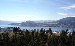
Okanagan Lake is a large, deep lake in the Okanagan Valley of British Columbia, Canada. The lake is 135 km long, between 4 and 5 km wide, and has a surface area of 348 km².[3][4][5]
Hydrography
Okanagan Lake is called a fjord lake as it has been carved out by repeated glaciations. Although the lake contains numerous lacustrine terraces, it is not uncommon for the lake to be 100m deep only 10m offshore.[6] Major inflows include Mission, Vernon, Trout, Penticton, Equesis, Kelowna, Peachland and Powers Creeks.[7] The lake is drained by the Okanagan River, which exits the lake's south end via a canal through the city of Penticton to Skaha Lake, whence the river continues southwards into the rest of the South Okanagan and through Okanogan County, Washington to its confluence with the Columbia.
The lake's maximum depth is 232 metres near Grant Island (Nahun Weenox). There is one other island known as Rattlesnake Island, much farther south by Squally Point. Some areas of the lake have up to 750 metres of glacial and post-glacial sediment fill which were deposited during the Pleistocene Epoch.[1]
Notable features of the Okanagan Valley include terraces which were formed due to the periodic lowering of the lake's predecessor, glacial Lake Penticton. These terraces are now used extensively for agriculture such as fruit cultivation.
Geographical context
Cities bordering the lake include Vernon in the north, Penticton in the south, and Kelowna, as well as the municipalities of Lake Country (north of Kelowna), West Kelowna (west of Kelowna), Peachland (south of West Kelowna), and Summerland (north-west of Penticton). Unincorporated communities include Naramata (north-east of Penticton).
Various lake features include Rattlesnake Island (a small island east of Peachland), Squally Point (a popular cliff-diving area) & Fintry Delta on the west side.
The five-lane William R. Bennett Bridge, a floating bridge with a high boat passage arch connects Kelowna to the city of West Kelowna and the community of Westbank. This bridge replaced the three-lane floating Okanagan Lake Bridge on May 30, 2008 which had a lift span for passage of large boats.
Steamboats of Lake Okanagan
.jpg)
Lake Okanagan, also called Okanagan Lake, is the largest lake in the Okanogan River drainage, which is tributary to the Columbia River basin, and is the core of the Okanagan region of British Columbia, Canada. During its early days of settlement and development, lack of roads in the region made the lake a natural corridor for passenger travel and freight. The Canadian Pacific Railway Lake and River Service was the main carrier on the lakes, providing freight and passenger connections between Penticton, on the Kettle Valley Railway (the Southern Mainline) and Okanagan Landing (Vernon) for connections to the CPR Mainline at Sicamous via the Shuswap and Okanagan Railway. Smaller vessels such as the SS Naramata provided passenger service to smaller settlements around the lake, as well as excursions for tourists.[8]
.jpg)
Vessels
- SS York (freight)
- SS Okanagan (luxury-class passenger service)
- SS Aberdeen (luxury-class passenger service)
- SS Sicamous (luxury-class passenger service)
- SS Fairview (sternwheeler)
- SS Naramata (excursion and water-taxi)
- MV Lequime (Fintry Queen, excursion and water-taxi)
- MV Lloyd-Jones - 1950-1960 (Bowen Queen 1960-1965, MV Vesuvius Queen 1965-1998)
- MV Pendozi (steel ferry)
- SS Kelowna (steam tug)
- SS Castlegar (steam tug)
- MV Aricia (ferry)
- SS Clovelly (ferry) (ferry)
- MV Grace Darling (1919 ferry)
- MV Grace Darling (1923 ferry)
- Canadian National Tug no. 6 (diesel tug)
- Canadian National Tug no. 5 (tug)
- MV Kelowna-Westbank (ferry)
- MV Skookum (1912) (1912 ferry)
- MV Skookum (1906) (1906 ferry)
- MV Rattlesnake (ferry)
- MV Trepanier (ferry)
- Colleen (rowboat)
- SS Maude-Moore (ferry)
- MV Mallard (ferry)
- MV Cygnet (ferry)
- SS Red Star (tug)
- SS Jubilee (early steamship)
- Ruth Shorts (rowboat)
- SS Mary Victoria Greenhow (early steamship)
- SS Wanderer (early steamship)
Landings
- Penticton
- Naramata
- Peachland
- Summerland
- Okanagan Mission
- Kelowna
- Okanagan Landing (Vernon)
- Fintry
- Carr's Landing
- Ewing (Ewing's Landing)
Recreation
Many parks and beaches are found along the shores of the lake, which make boating and swimming very popular activities.
The lake is home to several species of fish, including rainbow trout and kokanee. It is said by some to be home to its own lake monster - a giant serpent-like creature named Ogopogo.
Images
| Wikimedia Commons has media related to Okanagan Lake. |
 Maude Roxby Wetlands sunset
 Boyce-Gyro Beach on a Winter Afternoon
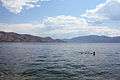 Swimmers in Peachland
 Half Way Bay during Golden Hour in Winter
 Late Winter Reflections on Lake Okanagan
See also
- Okanagan Falls
- Okanagan people
- Okanagan Trail
- List of tributaries of the Columbia River
- Kelowna Hydrofest
- Skaha Lake
- Summerhill Pyramid Winery
References
- 1 2 Eyles, N., Mullins, H.T., and Hine, A.C. (1990). "Thick and fast: Sedimentation in a Pleistocene fiord lake of British Columbia, Canada". Geology. 18 (11): 1153–1157. Bibcode:1990Geo....18.1153E. doi:10.1130/0091-7613(1990)018<1153:TAFSIA>2.3.CO;2.
- ↑ "Okanagan Lake". BC Geographical Names.
- ↑ Limnology of the Major Lakes in the Okanagan Basin. Canada - British Columbia Okanagan Basin Agreement, Final Report, Technical Supplement V. (PDF) (Report). Penticton, British Columbia: British Columbia Water Resources Service. April 1974. p. 46. Retrieved 2015-10-22.
Okanagan Lake surface area: 348 * 106 m2. Dat compiled by the charts of the Fish and Wildlife Branch, Department of Recreation and Conservation, BC.
- ↑ Stockner J.G.; Northcote T.G. (1974). "Recent limnological studies of Okanagan Basin lakes and their contribution to comprehensive water resource planning". Journal of the Fisheries Research Board of Canada. 31: 955–976. doi:10.1139/f74-111.
- ↑ "Okanagan Lake". World Lakes Database. International Lake Environment Committee Foundation. Retrieved 2006-05-12.
- ↑ Murray A., Roed (1995). "Chapter 5: The ice Age in the Okanagan". In Roed, Murray A. Okanagan Geology: British Columbia. Okanagan Geology Committee. p. 48. ISBN 978-0-9699795-4-8.
- ↑ "CHAPTER 1: The Okanagan Basin" in section "1.2 Drainage". CANADA - BRITISH COLUMBIA OKANAGAN BASIN AGREEMENT THE MAIN REPORT OF THE CONSULTATIVE BOARD, Part 1 Introduction (Report). Penticton, British Columbia: British Columbia Water Resources Service. March 31, 1974. p. 5.
Major tributaries of Okanagan Lake, listed in order of decreasing annual discharge are Mission, Vernon, Trout, Penticton, Equesis, Kelowna, Peachland and Powers Creeks.
- ↑ Penticton Museum displays, and heritage signs at the Okanagan Lake Heritage Shipyard on Okanagan Beach in Penticton.
External links
- Bacon Magazine: The Ogo Pogo
- Okanagan Lake History website
- Gallery of Okanagan Lake steamboats
 Media related to Okanagan Lake at Wikimedia Commons
Steamboats of British Columbia | |||||||||||||||||||||||||||||||||||||||||||||||
|---|---|---|---|---|---|---|---|---|---|---|---|---|---|---|---|---|---|---|---|---|---|---|---|---|---|---|---|---|---|---|---|---|---|---|---|---|---|---|---|---|---|---|---|---|---|---|---|
| |||||||||||||||||||||||||||||||||||||||||||||||
| |||||||||||||||||||||||||||||||||||||||||||||||
| |||||||||||||||||||||||||||||||||||||||||||||||
| |||||||||||||||||||||||||||||||||||||||||||||||
See also: Puget Sound Mosquito Fleet | |||||||||||||||||||||||||||||||||||||||||||||||