Robson Valley
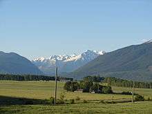
The Robson Valley is a geographic region of the Canadian province of British Columbia,[1] comprising the section of the Rocky Mountain Trench that lies southeast of the city of Prince George following the Fraser River to the Yellowhead Pass. The name is derived from Mount Robson, which stands near the entrance to the Yellowhead Pass. Communities in the Robson Valley include the settlements of Dome Creek, Crescent Spur, Dunster, and Tête Jaune Cache, with larger population concentrations in the villages of McBride and Valemount. On a map, the Robson Valley is located immediately south of the elbow in the boundary between Alberta and British Columbia. Transportation corridors through the Robson Valley include the CN rail lines, and Highways 16 and 5.
The Robson Valley is bounded on the south by the Columbia Country, farther south down the Rocky Mountain Trench, and the Thompson Country, via Canoe Pass , and is flanked on its east by the Rocky Mountains and on the west by the Cariboo Mountains.
References
Coordinates: 53°15′00″N 120°00′00″W / 53.25000°N 120.00000°W