Rutland, British Columbia
| Rutland | |
| neighbourhood | |
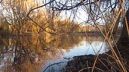 Winter Afternoon in Chichester Wetland Park | |
| Country | Canada |
|---|---|
| Province | British Columbia |
| Region | Okanagan |
| City | Kelowna |
| Coordinates | 49°54′N 119°23′W / 49.900°N 119.383°WCoordinates: 49°54′N 119°23′W / 49.900°N 119.383°W |
 | |
Rutland is a neighbourhood of the City of Kelowna in the Okanagan region of the Southern Interior of British Columbia, Canada, located on the northeast edge of the city's core.[1] Nearby neighbourhoods include Dilworth, Belgo, Black Mountain, Toovey Heights, Hall Road, Ellison, Central City, and Southeast Kelowna.[2] It is a member of the Osoyoos Division Yale Land District.[1]
The neighbourhood is mostly residential, but also has a thriving business community and Kelowna City council is working with community groups to make plans for revitalization of Rutland Town Centre.
History
Rutland was established when John "Hope" Rutland built an irrigation system allowing farming in the region. The post office was opened on October 1, 1908.[3]
Rutland was an unincorporated town until it was merged with the nearby city of Kelowna in 1973[4] by an act of the provincial legislature.
Rutland is named for an early settler, John "Hope" Matthew Rutland. Rutland, who had previously lived at Australian, near Quesnel, farmed wheat, planted the first commercial orchards, and installed the first large irrigation system in the area. In the 1900s he sold his land to a syndicate which subdivided the land and adjacent land and named the district after him.[1]
References
External links
| Wikimedia Commons has media related to Rutland, British Columbia. |
Municipalities and communities of Okanagan, British Columbia, Canada | ||
|---|---|---|
| Cities | 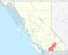 | |
| Towns | ||
| Districts | ||
| Villages | ||
| Designated places |
| |
| Unincorporated communities | ||
| Indian reservations | ||
| Ghost towns | ||
| Footnotes | ‡This populated place also has portions in an adjacent region | |