Naustdal
| Naustdal kommune | |||
|---|---|---|---|
| Municipality | |||
 | |||
| |||
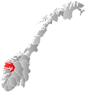
 Naustdal within Sogn og Fjordane | |||
| Coordinates: 61°33′38″N 05°51′19″E / 61.56056°N 5.85528°ECoordinates: 61°33′38″N 05°51′19″E / 61.56056°N 5.85528°E | |||
| Country | Norway | ||
| County | Sogn og Fjordane | ||
| District | Sunnfjord | ||
| Administrative centre | Naustdal | ||
| Government | |||
| • Mayor (2007) | Håkon Myrvang (Ap) | ||
| Area | |||
| • Total | 369.71 km2 (142.75 sq mi) | ||
| • Land | 355.75 km2 (137.36 sq mi) | ||
| • Water | 13.96 km2 (5.39 sq mi) | ||
| Area rank | 250 in Norway | ||
| Population (2013) | |||
| • Total | 2,713 | ||
| • Rank | 288 in Norway | ||
| • Density | 7.6/km2 (20/sq mi) | ||
| • Change (10 years) | -0.7 % | ||
| Demonym(s) |
Naustedøling Naustedøl[1] | ||
| Time zone | CET (UTC+1) | ||
| • Summer (DST) | CEST (UTC+2) | ||
| ISO 3166 code | NO-1433 | ||
| Official language form | Nynorsk | ||
| Website |
www | ||
|
| |||

Naustdal is a municipality in Sogn og Fjordane county, Norway. It is located in the traditional district of Sunnfjord. The administrative centre is the village of Naustdal, which has 1,138 inhabitants (2012). Other villages in Naustdal include Indrevevring and Helle.
Naustdal is situated between the towns of Førde and Florø, along the Norwegian National Road 5 highway. The Naustdal Tunnel runs through the mountains to connect to the town of Florø. The Førde Airport in Bringeland in Gaular municipality is the closest regional airport, and it lies about 30 kilometres (19 mi) from Naustdal.
Naustdal is a farming community with a diversity and cultural activities ranging from annual art exhibitions at Vevring to fairs, music, and dancing. Several renowned artists and writers come from Naustdal. Some of the local farmers breed horses, and horse shows are held every second year. Athletes from Naustdal do very well both in national and international championships, especially in volleyball and weightlifting.
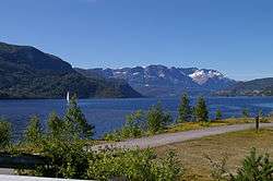
Naustdal offers rich opportunities for outdoor life such as fishing on the fjord from hired boats. The famous salmon river, Nausta, is in one of the county's largest wilderness areas with mountains, streams, lakes, and mountain farms, and it attracts many tourists from around the world. A recreational area and marina has recently been laid out near the center of Naustdal.
General information


Naustdal was established as a municipality on 1 January 1896. The municipality was a sub-parish (sokn) of the Førde parish before 1896 when it became a municipality of its own (see formannskapsdistrikt).[2] Upon its creation, Naustdal had a population of 2,543.
On 1 January 1964, all of Naustdal north of the Førdefjorden (population: 1,633) and all of the municipality of Vevring that was to the north of the Førdefjorden (population: 439) were merged to form the new municipality of Naustdal. The parts of Naustdal that were located south of the Førdefjorden (population: 265) were transferred to the municipality of Førde.[3]
Name
The municipality (originally the parish) is named after the Naustdal farm (Old Norse Naustdalr) since the first church (Naustdal Church) was built there. The first element is naust which means "boathouse" and the last element is dalr which means "valley" or "dale". The name of the river Nausta is also derived from the name of the farm.[4]
Coat-of-arms
The coat-of-arms is from modern times (1987). The jagged line symbolizes the profile of the gables of three boathouses (naust in Norwegian).
Churches
The Church of Norway has two parishes (sokn) within the municipality of Naustdal. It is part of the Sunnfjord deanery in the Diocese of Bjørgvin.
| Parish (Sokn) | Church Name | Location of the Church | Year Built |
|---|---|---|---|
| Naustdal | Naustdal Church | Naustdal | 1891 |
| Vevring | Vevring Church | Indrevevring | 1846 |
Government
All municipalities in Norway, including Naustdal, are responsible for primary education (through 10th grade), outpatient health services, senior citizen services, unemployment and other social services, zoning, economic development, and municipal roads. The municipality is governed by a municipal council of elected representatives, which in turn elect a mayor.
Municipal council
The municipal council (Kommunestyre) of Naustdal is made up of 21 representatives that are elected to every four years. For 2011–2015, the party breakdown is as follows:[5]
| Party Name | Name in Norwegian | Number of representatives | |
|---|---|---|---|
| Labour Party | Arbeiderpartiet | 6 | |
| Progress Party | Framstegspartiet | 1 | |
| Conservative Party | Høgre | 4 | |
| Christian Democratic Party | Kristelig Folkeparti | 1 | |
| Red Party | Raudt | 1 | |
| Centre Party | Senterpartiet | 4 | |
| Socialist Left Party | Sosialistisk Venstreparti | 2 | |
| Liberal Party | Venstre | 2 | |
| Total number of members: | 21 | ||
Mayor
The mayor (ordførar) of a municipality in Norway is a representative of the majority party of the municipal council who is elected to lead the council. Håkon Myrvang of the Norwegian Labour Party was re-elected mayor for the 2011-2015 term.[6]
Geography
Naustdal is located on the north shore of the Førdefjorden, stretching from the mouth of the fjord to the east, almost reaching to the end of the fjord. It is bordered to the north by the municipalities of Flora and Gloppen, to the east by Jølster, to the south by Førde, and to the south and west by Askvoll.
Climate
The climate in Naustdal is wet with a short summer and a mild winter. Naustdal has a yearly precipitation of 2,335 millimetres (91.9 in). There are great regional differences in the climate. There is snow rarely more than a week furthest out in the fjord. Up in the valley the first snow comes in early October and stays until late April/May and 1 to 2 metres (3 ft 3 in to 6 ft 7 in) of snow is common.
| Climate data for Naustdal | |||||||||||||
|---|---|---|---|---|---|---|---|---|---|---|---|---|---|
| Month | Jan | Feb | Mar | Apr | May | Jun | Jul | Aug | Sep | Oct | Nov | Dec | Year |
| Daily mean °C (°F) | −1.2 (29.8) |
−1 (30) |
1.8 (35.2) |
4.6 (40.3) |
9.7 (49.5) |
13.0 (55.4) |
14.2 (57.6) |
13.7 (56.7) |
10.3 (50.5) |
7.2 (45) |
2.3 (36.1) |
0.2 (32.4) |
6.2 (43.2) |
| Average precipitation mm (inches) | 221 (8.7) |
163 (6.42) |
186 (7.32) |
110 (4.33) |
96 (3.78) |
123 (4.84) |
141 (5.55) |
167 (6.57) |
299 (11.77) |
290 (11.42) |
268 (10.55) |
271 (10.67) |
2,335 (91.92) |
| Source: Norwegian Meteorological Institute[7] | |||||||||||||
Fishing
Inland fishing
The municipality of Naustdal is ideal for freshwater fishing. Over 30 lakes and connecting streams contain trout. Many of the lakes also contain char. Most of your catch will be small fish, but will taste delicious when fried in a pan. In the right places you can also catch really big fish–6 kilograms (13 lb) trout have been caught in this area.
Salmon and sea trout fishing
The Nausta river is one of the best rivers for salmon in Sogn og Fjordane county. Salmon travel 12 kilometres (7.5 mi) upstream from the river mouth. The stretch from the fjord to the Hovefoss waterfall is also good for sea trout fishing. The small Redal water system contains small salmon, sea trout, trout, and char. Small salmon and sea trout are best caught during floods.
Sea fishing
Naustdal has 40 kilometres (25 mi) of shoreline bordering on the fjord. Distances from motor roads to the sea are short at all locations. In outlying, non-farming areas, fishing from the seashore is unrestricted. Fishing from boats on the fjord using a rod or line is free for all. The main types of fish caught in the area include cod, saithe, mackerel, herring, salmon, and sea trout, although every type of fish commonly found in Norwegian waters can be caught here. The Russenes recreational area near the sound at Ålesundet is an excellent place for fishing from land, offering a one-mile shoreline. For boat fishing trips contact boat rental agents or the "Russenes Tur og Fiske", who will bring you to the best fishing places.
Attractions


Nausta river
From the old bridge across the Nausta river near the waterfall Naustdalsfossen you can watch salmon conquer the waterfall in powerful leaps—unless they are caught by rivaling anglers on the banks of the plunging pool. Hooking the fish is difficult — landing it a work of art. The local landowners will show you the best fishing places. Fishing permits may be purchased at the local petrol station or from the landowners. Nausta was in 2005 ranked best in Sogn og Fjordane and number 19 nationally with a total catch of 4,698 kilograms (10,357 lb).
Mountains
The large mountain area in the eastern part of Naustdal offers a wealth of scenery. There are large lakes and connecting streams. The trout fishing is excellent and fishing permits are available. "Longvasshytta", a self-catering cabin for hikers, can be reached after a 6-hour hike from the nearest road.
Russenes
Recreational grounds have been laid out at Russeneset near the inlet Ålesundet. Several footpaths in the area are signposted. Along the paths you will find information posters about cultural history, flora and fauna. Excellent for fishing, swimming, bird watching or just walking.
Sanden Beach
Recreational grounds are laid out along the fjord near the center of Naustdal. There is a marina, sandy beach, diving tower, and a place for beach volleyball.
Air Combat Museum
The museum covers the air battle between German and British aircraft over Sunnfjord on 9 February 1945, also known at the Black Friday. In the museum there are objects from the battles, airplane parts, maps, and photographs. It has a rich collection of splendid model airplanes from the navigator Bernard Nicholl, who participated in the battles.[8]
Notable residents
- Gunnvor Aase
- Ingrid Aase
- Kristin Aase
- Jetmund Berntsen
- Martin Berntsen
- Merita Berntsen Mol
- Sigbjørn Gjelsvik
- Stian Grimseth
- Geir Grønnevik
- Vidar Koksvik
- Steinar Kvame
- Eldrid Lunden
- Gunnar Reiakvam
- Odd Gunnar Røyseth
- Kjartan Slettemark
- Vidar Slettehaug (National Rugby Champion)
- Bård Vegar Solhjell
- Arild Stubhaug
- Oddvar Torsheim
- Iselin Solheim
References
- ↑ "Navn på steder og personer: Innbyggjarnamn" (in Norwegian). Språkrådet. Retrieved 2015-12-01.
- ↑ Natvik, Oddvar (9 February 2005). "Some historical data on the 26 Kommunes".
- ↑ Jukvam, Dag (1999). "Historisk oversikt over endringer i kommune- og fylkesinndelingen" (PDF) (in Norwegian). Statistics Norway.
- ↑ Rygh, Oluf (1919). Norske gaardnavne: Nordre Bergenhus amt (in Norwegian) (12 ed.). Kristiania, Norge: W. C. Fabritius & sønners bogtrikkeri. p. 336.
- ↑ "Members of the local councils". Statistics Norway. 2011. Retrieved 2013-11-19.
- ↑ "Naustdal Kommunestyre 2007-2011" (in Norwegian). Naustdal Kommune. Retrieved 6 August 2008.
- ↑ "eKlima Web Portal". Norwegian Meteorological Institute.
- ↑ "Naustdal Municipality in Norway". Retrieved 11 August 2008.