Vevring
| Vevring herad | |
|---|---|
| Former Municipality | |
|
Vevring church | |
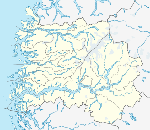 Vevring herad Location in Sogn og Fjordane county | |
| Coordinates: 61°29′29″N 05°23′44″E / 61.49139°N 5.39556°ECoordinates: 61°29′29″N 05°23′44″E / 61.49139°N 5.39556°E | |
| Country | Norway |
| Region | Western Norway |
| County | Sogn og Fjordane |
| District | Sunnfjord |
| Municipality ID | NO-1434 |
| Admin. Center | Indrevevring |
| Area[1] | |
| • Total | 120 km2 (50 sq mi) |
| Population (2001) | |
| • Total | 143 |
| Time zone | CET (UTC+01:00) |
| • Summer (DST) | CEST (UTC+02:00) |
| Created as | Formannskapsdistrikt in 1838 |
| Merged into | Flora, Askvoll, and Naustdal in 1964 |

Vevring is a former municipality in Sogn og Fjordane county, Norway. The municipality existed from 1838 until its dissolution in 1964. It encompassed the land surrounding the western part of the Førdefjorden on both the north and south shores of the fjord. It stretched from the Ålasundet strait (the narrowest part of the fjord) in the east to the mouth of the fjord in the west and from the Steindalen valley in the north to the mountains south of the fjord. The municipality was 120 square kilometres (46 sq mi) in 1964 when it was dissolved.
The administrative centre of the municipality was the village of Indrevevring (on the north shore of the fjord), where the Vevring Church is located. The village of Kvammen, across the fjord from Indrevevring was the main village on the south side of the fjord.
Name
The municipality was named after the old Vevring farm (Old Norse: Wæfring), since Vevring Church is located there. The farm was named after a stream that flowed past it. The name of the stream comes from the Old Norse word vafra which means to "go here and there", which describes the path of the stream.[1][2]
History
The parish of Vevring was established as a municipality on 1 January 1838 (see formannskapsdistrikt). On 1 January 1964, the municipality was dissolved and split between three surrounding municipalities. The Steindal valley (population: 25) in the north was incorporated into the new municipality of Flora; the area south of the Førdefjorden was incorporated into Askvoll Municipality. The rest of Vevring (north of the Førdefjorden), with 439 inhabitants, became a part of Naustdal Municipality.[3]
References
- 1 2 "Vevring" (in Norwegian). Store norske leksikon. Retrieved 2009-12-15.
- ↑ Rygh, Oluf (1919). Norske gaardnavne: Nordre Bergenhus amt (in Norwegian) (12 ed.). Kristiania, Norge: W. C. Fabritius & sønners bogtrikkeri. p. 348.
- ↑ Jukvam, Dag (1999). "Historisk oversikt over endringer i kommune- og fylkesinndelingen" (PDF) (in Norwegian). Statistisk sentralbyrå.
External links
 Sogn og Fjordane travel guide from Wikivoyage
- Map of Vevring municipality from 1919 (Norwegian)