Gaular
| Gaular kommune | |||
|---|---|---|---|
| Municipality | |||
 | |||
| |||
 Gaular within Sogn og Fjordane | |||
| Coordinates: 61°20′02″N 05°47′20″E / 61.33389°N 5.78889°ECoordinates: 61°20′02″N 05°47′20″E / 61.33389°N 5.78889°E | |||
| Country | Norway | ||
| County | Sogn og Fjordane | ||
| District | Sunnfjord | ||
| Administrative centre | Sande | ||
| Government | |||
| • Mayor (2011) | Mathias Råheim (H) | ||
| Area | |||
| • Total | 581.94 km2 (224.69 sq mi) | ||
| • Land | 539.04 km2 (208.12 sq mi) | ||
| • Water | 42.90 km2 (16.56 sq mi) | ||
| Area rank | 187 in Norway | ||
| Population (2012) | |||
| • Total | 2,923 | ||
| • Rank | 274 in Norway | ||
| • Density | 5.4/km2 (14/sq mi) | ||
| • Change (10 years) | 4.5 % | ||
| Demonym(s) | Gaulværing[1] | ||
| Time zone | CET (UTC+1) | ||
| • Summer (DST) | CEST (UTC+2) | ||
| ISO 3166 code | NO-1430 | ||
| Official language form | Nynorsk | ||
| Website |
www | ||
|
| |||

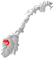
Gaular is a municipality in Sogn og Fjordane county, Norway. It is located in the traditional district of Sunnfjord. The administrative centre is the village of Sande. Other villages in the municipality include Bygstad, Hestad, and Vik.
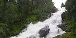
Gaular is sometimes referred to as Fosselandet (the land of the waterfalls) because it is home to 28 large and small waterfalls. The municipality is centered on the river Gaula. The Viksdalen valley is located in Gaular.
General information

The parish of Indre Holmedal was established as a municipality on 1 January 1838 (see formannskapsdistrikt). The original municipality was identical to the Indre Holmedal parish (prestegjeld) which included the sub-parishes (sokn) of Bygstad, Sande, and Vik. In 1912, the name of the municipality was changed to Gaular.[2] On 1 January 1990, parts of the Hestad area (west of Sunde-Klepp, west of Bygstad) were transferred from Fjaler to Gaular.[3]
Name
The name (Old Norse Gaular) is derived from the name of the river Gaula. The old name of the area was revived in 1912, prior to that the name of the municipality was Indre Holmedal, meaning the inner part of Holmedal.[4]
Coat-of-arms
The coat-of-arms is from modern times; they were granted on 24 April 1992. The arms are green with a wavy silver line running straight up and down across the arms. It represents the river Gaula which passes through the forested municipality.[5]
Churches
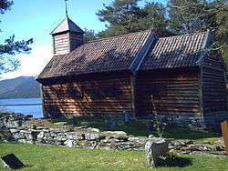
The Church of Norway has one parish (sokn) within the municipality of Gaular. It is part of the Sunnfjord deanery in the Diocese of Bjørgvin.[6]
| Parish (Sokn) | Church Name | Location of the Church | Year Built |
|---|---|---|---|
| Gaular | Bygstad Church | Bygstad | 1845 |
| Sande Church | Sande | 1864 | |
| Hestad Chapel | Hestad | 1805 | |
| Viksdalen Church | Vik | 1848 |
Government
| Historical population | ||
|---|---|---|
| Year | Pop. | ±% |
| 1769 | 1,874 | — |
| 1951 | 3,039 | +62.2% |
| 1960 | 2,854 | −6.1% |
| 1970 | 2,657 | −6.9% |
| 1980 | 2,809 | +5.7% |
| 1990 | 2,939 | +4.6% |
| 2000 | 2,886 | −1.8% |
| 2010 | 2,778 | −3.7% |
| Source: Statistics Norway. The population has decreased mainly because of emigration to Bergen and the United States. | ||
All municipalities in Norway, including Gaular, are responsible for primary education (through 10th grade), outpatient health services, senior citizen services, unemployment and other social services, zoning, economic development, and municipal roads. The municipality is governed by a municipal council of elected representatives, which in turn elect a mayor.
Municipal council
The municipal council (Kommunestyre) of Gaular is made up of 21 representatives that are elected to every four years. For 2011–2015, the party breakdown is as follows:[7]
| Party Name | Name in Norwegian | Number of representatives | |
|---|---|---|---|
| Labour Party | Arbeiderpartiet | 3 | |
| Conservative Party | Høgre | 7 | |
| Christian Democratic Party | Kristelig Folkeparti | 3 | |
| Centre Party | Senterpartiet | 6 | |
| Socialist Left Party | Sosialistisk Venstreparti | 1 | |
| Liberal Party | Venstre | 1 | |
| Total number of members: | 21 | ||
Mayor
The mayor (ordførar) of a municipality in Norway is a representative of the majority party of the municipal council who is elected to lead the council. Mathias Råheim of the Conservative Party was elected mayor for the 2011-2015 term.[8]
Geography


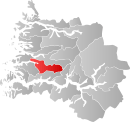
Gaular is located in the central part of Sogn og Fjordane county, in the Sunnfjord region. It is bordered to the north by the municipalities of Askvoll and Førde, to the east by Balestrand, to the south by Høyanger, and to the west by Fjaler.
The Gaula River flows west through the municipality and empties into the Dalsfjorden near the village of Bygstad. There are several large lakes that are part of the river Gaula including the lakes Haukedalsvatnet and Viksdalsvatnet. The river begins in the Gaularfjellet mountains to the east of the municipality.
Transportation
The European route E39 highway runs through the centre of Sande south to the city of Bergen, a distance of 150 kilometres (93 mi) (with a ferry between the villages of Lavik and Oppedal across the Sognefjorden). The Norwegian County Road 13 runs through the eastern part of the municipality. Førde Airport, Bringeland (ENBL) is located at Bringelandsåsen in Gaular municipality.
Attractions
The Salmon Stairs
William T. Potts from Coreen Castle in Ireland initiated the building of the salmon stairs (a type of fish ladder), which were completed in 1871, in return for an agreement made with the farmers that had 25 years of free fishing. The salmon stairs at Osen in Bygstad are the oldest in the world. The stairs consist of 17 pools/stages and has height of around 11 metres (36 ft). It is very effective as the salmon are forced to make their way up the stair construction, due to the current below the falls.[9]
National Tourist Road
Fylkesvei 13 (Fv13) is one of 18 national tourist roads in Norway because of the nearby waterfalls. From near the town of Førde, drivers start on a sightseeing journey with cultural attractions that date from the 19th century to the present day's city environment. The districts of Holsen and Haukedalen are typical of Western Norwegian farming communities that have created a picturesque cultivated landscape.
Rørvik Mountain is on the road and it has fascinating stone walls and a marvellous view over the Haukedalen valley. Along Råheimsdalen and Eldalen to the Gaularfjellet mountains, you will see a marvellous waterfall landscape that has been landscaped with paths for visitors. From the top of Gaularfjellet mountains, hairpin bends wind down to the Vetlefjorden, an arm of the Sognefjorden. The breathtaking contrasts of steep mountainsides, winding roads, and waterfalls are characteristic of Western Norway's exceptional scenery. [9]
References
- ↑ "Navn på steder og personer: Innbyggjarnamn" (in Norwegian). Språkrådet. Retrieved 2015-12-01.
- ↑ Natvik, Oddvar (9 February 2005). "Some historical data on the 26 Kommunes".
- ↑ Jukvam, Dag (1999). "Historisk oversikt over endringer i kommune- og fylkesinndelingen" (PDF) (in Norwegian). Statistics Norway.
- ↑ Rygh, Oluf (1919). Norske gaardnavne: Nordre Bergenhus amt (in Norwegian) (12 ed.). Kristiania, Norge: W. C. Fabritius & sønners bogtrikkeri. p. 287.
- ↑ "Civic heraldry of Norway - Norske Kommunevåpen". Heraldry of the World. Retrieved 2013-12-03.
- ↑ "Kyrkjeleg fellesråd" (in Norwegian). Gaular kommune. Retrieved 2013-12-03.
- ↑ "Members of the local councils". Statistics Norway. 2011. Retrieved 2013-12-03.
- ↑ Fossheim, Eldgrim (17 June 2007). "Gaular" (in Norwegian). NRK.no. Retrieved 6 August 2008. External link in
|publisher=(help) - 1 2 "Førde Municipality in Norway". GoNorway.no. Retrieved 11 August 2008.