Sunnfjord
| Sunnfjord | |
|---|---|
| District | |
|
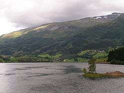
View of Viksdalsvatnet | |
|
Sunnfjord | |
| Country | Norway |
| County | Sogn og Fjordane |
| Region | Vestlandet |
| Adm. Center | Florø[1] |
| Area | |
| • Total | 4,476 km2 (1,728 sq mi) |
| Population (2006) | |
| • Total | 41,156 |
| • Density | 9.2/km2 (24/sq mi) |
| Demonym(s) | Sunnfjording |

| Historical population | ||
|---|---|---|
| Year | Pop. | ±% |
| 1769 | 11,545 | — |
| 1951 | 26,271 | +127.6% |
| 1960 | 26,368 | +0.4% |
| 1970 | 27,153 | +3.0% |
| 1980 | 31,299 | +15.3% |
| 1990 | 33,511 | +7.1% |
| 2000 | 36,591 | +9.2% |
| 2010? | 37,678 | +3.0% |
| 2020? | 39,363 | +4.5% |
| 2030? | 41,250 | +4.8% |
| Source: Statistics Norway. | ||
Sunnfjord (English: the southern fjord - in contrast to Nordfjord) is a traditional district in Western Norway located in Sogn og Fjordane county. It includes the municipalities of Askvoll, Fjaler, Flora, Førde, Gaular, Jølster, Naustdal, and the southernmost parts of Bremanger. It covers an area of about 4,476 square kilometres (1,728 sq mi) and has a population (2006) of 41,156–about 32% of the population of Sogn og Fjordane county.[1]
The central geographical characteristic of the Sunnfjord region are the fjords Dalsfjorden and Førdefjorden. It is a popular tourist region, with spectacular waterfalls, fishing, white-water rafting, glaciers, hiking, and beautiful scenery–including Jostedalsbreen National Park.[1]
The area was the site of the largest air battle over Norway during World War II, and a museum is dedicated to the event in Naustdal. There are two airports in Sunnfjord: Førde Airport, Bringeland, just outside the city of Førde, and Florø Airport, just outside the city of Florø. The highway E39 passes through the region, going north and south.
Notable residents
- Gaahl, Norwegian vocalist
References
- 1 2 3 Store norske leksikon. "Sunnfjord" (in Norwegian). Retrieved 2010-08-07.
Coordinates: 61°29′35″N 5°32′25″E / 61.4930°N 5.5404°E