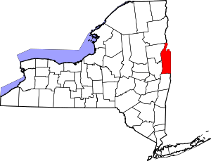
| [3] |
Name on the Register |
Image |
Date listed[4] |
Location |
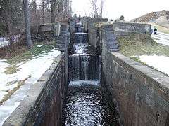
City or town |
Description |
|---|
| 1 |
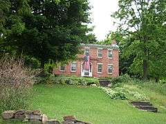
Susan B. Anthony Childhood House |
Upload image |
000000002007-04-13-0000April 13, 2007
(#06001079) |
2835 NY 29
43°06′38″N 73°25′23″W / 43.110556°N 73.423056°W / 43.110556; -73.423056 (Susan B. Anthony Childhood House) |
Battenville |
|
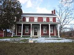
| 2 |
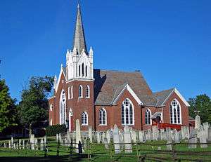
Baker-Merrill House |
Upload image |
000000002006-07-26-0000July 26, 2006
(#06000650) |
38 Grove Rd.
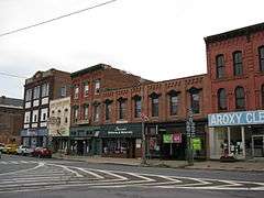
42°59′28″N 73°33′06″W / 42.991111°N 73.551667°W / 42.991111; -73.551667 (Baker-Merrill House) |
Easton |
|
| 3 |
Brown's Tavern |
Upload image |
000000002000-09-22-0000September 22, 2000
(#00001154) |
7755 NY 40
43°20′41″N 73°24′35″W / 43.344722°N 73.409722°W / 43.344722; -73.409722 (Brown's Tavern) |
South Hartford |
|
| 4 |
Burton Hall |
Upload image |
000000002015-09-17-0000September 17, 2015
(#15000610) |
1071 NY 40
43°06′13″N 73°31′30″W / 43.1035921°N 73.5249235°W / 43.1035921; -73.5249235 (Burton Hall) |
North Easton |
1901 Easton town hall built through efforts of local philanthropist
|
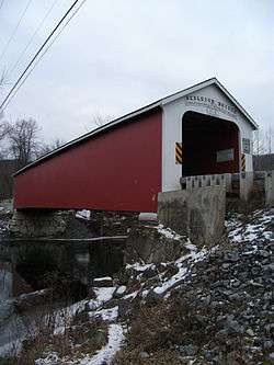
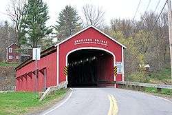
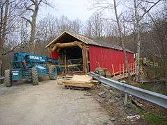
| 5 |
Buskirk Covered Bridge |
|
000000001978-03-08-0000March 8, 1978
(#78003457) |
Spans Hoosic River north of NY 67
42°57′30″N 73°26′00″W / 42.958333°N 73.433333°W / 42.958333; -73.433333 (Buskirk Covered Bridge) |
Buskirk |
part of the Covered Bridges of Washington County Thematic Resource (TR)
|
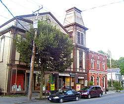
| 6 |
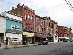
Cambridge Historic District |
|
000000001978-11-15-0000November 15, 1978
(#78001922) |
Irregular pattern along Main and S. Union Sts.
43°01′30″N 73°22′58″W / 43.025°N 73.382778°W / 43.025; -73.382778 (Cambridge Historic District) |
Cambridge |
Historic remnants of the three hamlets that merged to form Cambridge
|
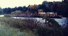
| 7 |
Champlain Canal |
|
000000001976-09-01-0000September 1, 1976
(#76001274) |
Extends north from Troy to Whitehall
43°09′34″N 73°34′48″W / 43.159364°N 73.579903°W / 43.159364; -73.579903 (Champlain Canal) |
extends from Waterford through Fort Edward to Whitehall |
|
| 8 |
Coffin Site |
|
000000001980-07-22-0000July 22, 1980
(#80002786) |
Address Restricted
|
Greenwich |
|
| 9 |
Hiram Congdon House |
Upload image |
000000001997-09-30-0000September 30, 1997
(#97001203) |
Northeast of the junction of NY 22 and B Rd.
43°41′58″N 73°25′52″W / 43.699444°N 73.431111°W / 43.699444; -73.431111 (Hiram Congdon House) |
Putnam |
|
| 10 |
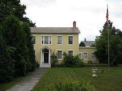
Dayton-Williams House |
|
000000002006-11-08-0000November 8, 2006
(#06001000) |
65 Dayton Hill Rd.
43°26′02″N 73°17′04″W / 43.433889°N 73.284444°W / 43.433889; -73.284444 (Dayton-Williams House) |
Middle Granville |
|
| 11 |
DeRidder Homestead |
Upload image |
000000001974-03-22-0000March 22, 1974
(#74001315) |
East of Schuylerville off NY 29
43°05′57″N 73°34′04″W / 43.099167°N 73.567778°W / 43.099167; -73.567778 (DeRidder Homestead) |
Easton |
|
| 12 |
Eagleville Covered Bridge |
|
000000001978-03-08-0000March 8, 1978
(#78003458) |
Spans Batten Kill off NY 313
43°05′00″N 73°18′51″W / 43.083333°N 73.314167°W / 43.083333; -73.314167 (Eagleville Covered Bridge) |
Eagleville in the towns of Jackson and Salem, New York |
part of the Covered Bridges of Washington County TR
|
| 13 |
Easton Friends North Meetinghouse |
Upload image |
000000002005-10-05-0000October 5, 2005
(#05001132) |
NY 40, Schaghticoke-Middle Falls Rd.
43°03′25″N 73°32′04″W / 43.056944°N 73.534444°W / 43.056944; -73.534444 (Easton Friends North Meetinghouse) |
Middle Falls |
|
| 14 |
Farmer's National Bank and W.H. Hughes Slate Company Office |
Upload image |
000000002014-06-13-0000June 13, 2014
(#14000330) |
44-46 Main St.
43°24′27″N 73°15′46″W / 43.4075601°N 73.2626593°W / 43.4075601; -73.2626593 (Farmer's National Bank and W.H. Hughes Slate Company Office) |
Granville |
Stone Colonial Revival buildings complementing the neighboring post office
|
| 15 |
Fort Edward D&H Train Station |
|
000000002000-12-13-0000December 13, 2000
(#00001527) |
East and Wing Sts.
43°16′11″N 73°34′51″W / 43.269722°N 73.580833°W / 43.269722; -73.580833 (Fort Edward D&H Train Station) |
Fort Edward |
part of the Glens Falls Multiple Resource Area (MRA)
|
| 16 |
Fort Miller Reformed Church Complex |
|
000000001996-12-06-0000December 6, 1996
(#96001431) |
Fort Miller Rd., west of US 4 and south of Galusha Island
43°09′49″N 73°34′55″W / 43.163611°N 73.581944°W / 43.163611; -73.581944 (Fort Miller Reformed Church Complex) |
Fort Edward |
|
| 17 |
Glens Falls Feeder Canal |
|
000000001985-10-25-0000October 25, 1985
(#85003401) |
Roughly between Richardson St. and the Old Champlain Canal
43°18′07″N 73°37′53″W / 43.301944°N 73.631389°W / 43.301944; -73.631389 (Glens Falls Feeder Canal) |
Hudson Falls |
|
| 18 |
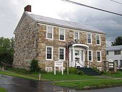
Hartford Baptist Church and Cemetery |
|
000000002004-08-20-0000August 20, 2004
(#04000875) |
56 NY 23 (Main St.)
43°21′53″N 73°23′35″W / 43.364722°N 73.393056°W / 43.364722; -73.393056 (Hartford Baptist Church and Cemetery) |
Hartford |
1891 late Victorian Gothic church built on site of congregation's first church in 1789.
|
| 19 |
Lemuel Haynes House |
|
000000001975-05-15-0000May 15, 1975
(#75001235) |
Rte. 149
43°22′16″N 73°17′00″W / 43.371111°N 73.283333°W / 43.371111; -73.283333 (Lemuel Haynes House) |
South Granville |
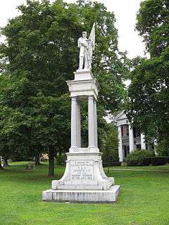
Last home of first ordained African-American minister in U.S. Currently Washington County's only National Historic Landmark
|
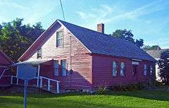
| 20 |
Hebron District School No. 16 |
Upload image |
000000002012-04-16-0000April 16, 2012
(#12000211) |
NY 22
43°15′44″N 73°17′14″W / 43.262277°N 73.287104°W / 43.262277; -73.287104 (Hebron District School No. 16) |
East Hebron |
|
| 21 |
Hebron Valley Grange No. 1103 |
Upload image |
000000002006-07-28-0000July 28, 2006
(#06000649) |
3185 Cty Rte 30
43°13′50″N 73°22′34″W / 43.230556°N 73.376111°W / 43.230556; -73.376111 (Hebron Valley Grange No. 1103) |
West Hebron |
|
| 22 |
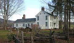
Home Farm |
|
000000002008-12-05-0000December 5, 2008
(#08001147) |
591 Co. Rt. 18
43°32′35″N 73°21′14″W / 43.543187°N 73.354027°W / 43.543187; -73.354027 (Home Farm) |
East Whitehall |
|
| 23 |
Hudson Falls Historic District |
|
000000001983-09-15-0000September 15, 1983
(#83001825) |
Roughly bounded by Oak, Mechanic, River, Maple and Main Sts.
43°18′00″N 73°35′09″W / 43.3°N 73.585833°W / 43.3; -73.585833 (Hudson Falls Historic District) |
Hudson Falls |
|
| 24 |
Main Street Historic District |
|
000000001975-04-24-0000April 24, 1975
(#75001236) |
Both sides of Williams St. and both sides of Main St. Bridge to below Saunders St. Bridge
43°33′22″N 73°24′07″W / 43.556111°N 73.401944°W / 43.556111; -73.401944 (Main Street Historic District) |
Whitehall |
|
| 25 |
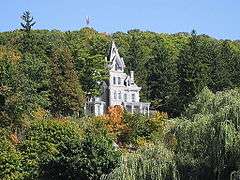
Martin–Fitch House and Asa Fitch Jr. Laboratory |
Upload image |
000000002014-06-09-0000June 9, 2014
(#14000290) |
4183 NY 29
43°09′05″N 73°22′55″W / 43.15137°N 73.3820717°W / 43.15137; -73.3820717 (Martin–Fitch House and Asa Fitch Jr. Laboratory) |
Salem |
Home and laboratory of Asa Fitch, first occupational entomologist in the U.S.
|
| 26 |
Maxwell Farm |
Upload image |
000000002012-06-27-0000June 27, 2012
(#12000368) |
311 County Rd. 61
43°06′19″N 73°24′13″W / 43.105283°N 73.403597°W / 43.105283; -73.403597 (Maxwell Farm) |
Jackson |
|
| 27 |
Thomas McLean House |
Upload image |
000000002007-10-31-0000October 31, 2007
(#07001128) |
NY 29
43°06′47″N 73°25′20″W / 43.113056°N 73.422222°W / 43.113056; -73.422222 (Thomas McLean House) |
Battenville |
|
| 28 |
Alexander McNish House |
Upload image |
000000002010-11-29-0000November 29, 2010
(#10000959) |
194 County Road 30
43°10′14″N 73°21′07″W / 43.170556°N 73.351944°W / 43.170556; -73.351944 (Alexander McNish House) |
Salem |
|
| 29 |
William Miller Chapel and Ascension Rock |
Upload image |
000000001975-07-17-0000July 17, 1975
(#75001233) |
West of Fair Haven on SR 11
• William Miller Farm Historic District boundary increase (listed 000000001994-04-04-0000April 4, 1994, refnum 94000256): Co. Rt. 11 west of US 4
43°35′42″N 73°18′45″W / 43.595°N 73.3125°W / 43.595; -73.3125 (William Miller Chapel and Ascension Rock) |
Hampton |
|
| 30 |
Old Fort House |
Upload image |
000000001983-09-15-0000September 15, 1983
(#83001826) |
29 Lower Broadway
43°15′40″N 73°34′51″W / 43.261111°N 73.580833°W / 43.261111; -73.580833 (Old Fort House) |
Fort Edward |
|
| 31 |
Old Stone House Library |
|
000000002013-03-06-0000March 6, 2013
(#13000055) |
36 George St.
43°24′44″N 73°29′18″W / 43.412327°N 73.488279°W / 43.412327; -73.488279 (Old Stone House Library) |
Fort Ann |
Built around 1825, this house is one of the few intact structures from the days of the Champlain Canal's construction
|
| 32 |
Judge Joseph Potter House |
|
000000001974-05-02-0000May 2, 1974
(#74001316) |
Mountain Ter.
43°33′21″N 73°23′58″W / 43.555833°N 73.399444°W / 43.555833; -73.399444 (Judge Joseph Potter House) |
Whitehall |
|
| 33 |
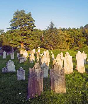
Revolutionary War Cemetery |
|
000000002004-08-11-0000August 11, 2004
(#04000822) |
9 Archibald St.
43°10′02″N 73°19′47″W / 43.167222°N 73.329722°W / 43.167222; -73.329722 (Revolutionary War Cemetery) |
Salem |
Oldest cemetery in town, with almost 1,100 graves, many local veterans of the war
|
| 34 |
Rexleigh Covered Bridge |
|
000000001978-03-08-0000March 8, 1978
(#78003459) |
Off NY 22
43°11′25″N 73°20′05″W / 43.190233°N 73.3348°W / 43.190233; -73.3348 (Rexleigh Covered Bridge) |
Jackson |
part of the Covered Bridges of Washington County TR
|
| 35 |
Rogers Island |
|
000000001973-07-24-0000July 24, 1973
(#73001283) |
Address Restricted
43°15′42″N 73°35′08″W / 43.261667°N 73.585556°W / 43.261667; -73.585556 (Rogers Island) |
Fort Edward |
|
| 36 |
St. James Episcopal Church |
|
000000001998-01-07-0000January 7, 1998
(#97001617) |
112 Broadway
43°16′02″N 73°35′06″W / 43.267222°N 73.585°W / 43.267222; -73.585 (St. James Episcopal Church) |
Fort Edward |
|
| 37 |
Salem Historic District |
|
000000001975-05-28-0000May 28, 1975
(#75001234) |
Both sides of Broadway and Main Sts. from RR tracks on N and W to include White Creek on S and E
43°10′19″N 73°19′39″W / 43.171944°N 73.3275°W / 43.171944; -73.3275 (Salem Historic District) |
Salem |
Historic core of one of the oldest settlements in the region, with many intact 19th century buildings
|
| 38 |
Shushan Covered Bridge |
|
000000001978-03-08-0000March 8, 1978
(#78003460) |
Spans Batten Kill off NY 22
43°05′28″N 73°20′45″W / 43.091111°N 73.345833°W / 43.091111; -73.345833 (Shushan Covered Bridge) |
Shushan |
part of the Covered Bridges of Washington County TR
|
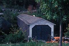
| 39 |
L. C. Simonds Adirondack Cabin |
Upload image |
000000002010-11-29-0000November 29, 2010
(#10000941) |
130 Cat Den Rd.
43°36′56″N 73°25′27″W / 43.615556°N 73.424167°W / 43.615556; -73.424167 (L. C. Simonds Adirondack Cabin) |
Clemons |
|
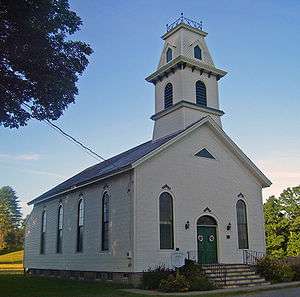
| 40 |
South Granville Congregational Church and Parsonage |
|
000000002005-05-19-0000May 19, 2005
(#05000442) |
7179 NY 149
43°22′19″N 73°17′15″W / 43.371944°N 73.2875°W / 43.371944; -73.2875 (South Granville Congregational Church and Parsonage) |
South Granville |
1840s church and parsonage; former expanded 1873
|
| 41 |
Stoops Hotel |
Upload image |
000000002009-06-30-0000June 30, 2009
(#09000481) |
2839 NY 29
43°06′56″N 73°25′20″W / 43.115639°N 73.422242°W / 43.115639; -73.422242 (Stoops Hotel) |
Battenville |
|
| 42 |
Elisha Straight House |
|
000000002004-09-15-0000September 15, 2004
(#04000986) |
55 Main St.
43°21′53″N 73°23′38″W / 43.364722°N 73.393889°W / 43.364722; -73.393889 (Elisha Straight House) |
Hartford |
Early home in Hartford used as recruitment center during Civil War. Now local history museum
|
| 43 |
Town-Hollister Farm |
Upload image |
000000002008-06-13-0000June 13, 2008
(#08000516) |
NY 22
Coordinates missing |
North Granville |
|
| 44 |
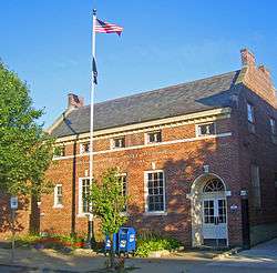
US Post Office-Granville |
|
000000001989-05-11-0000May 11, 1989
(#88002520) |
41 Main St.
43°26′03″N 73°15′35″W / 43.434167°N 73.259722°W / 43.434167; -73.259722 (US Post Office-Granville) |
Granville |
One of only three Colonial Revival post offices with a raised parapet along the gables. Asymmetrical fenestration is unusual in a Depression-era post office of that size. Part of the US Post Offices in New York State, 1858-1943, TR
|
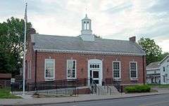
| 45 |
US Post Office-Hudson Falls |
|
000000001989-05-11-0000May 11, 1989
(#88002509) |
114 Main St.
43°17′59″N 73°35′08″W / 43.299722°N 73.585556°W / 43.299722; -73.585556 (US Post Office-Hudson Falls) |
Hudson Falls |
part of the US Post Offices in New York State, 1858-1943, TR
|
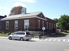
| 46 |
US Post Office-Whitehall |
|
000000001989-05-11-0000May 11, 1989
(#88002447) |
88 Broadway
43°33′12″N 73°24′16″W / 43.553333°N 73.404444°W / 43.553333; -73.404444 (US Post Office-Whitehall) |
Whitehall |
part of the US Post Offices in New York State, 1858-1943, TR
|
| 47 |
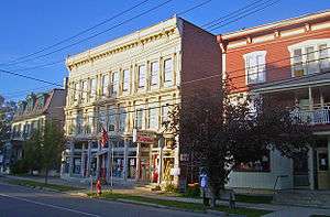
Village of Greenwich Historic District |
|
000000001995-08-31-0000August 31, 1995
(#95001025) |
Roughly, along Academy, Church, Cottage, Gray, Main, Prospect and Salem Sts. and Washington Sq., Town of Greenwich
43°05′30″N 73°29′55″W / 43.091667°N 73.498611°W / 43.091667; -73.498611 (Village of Greenwich Historic District) |
Greenwich |
|
| 48 |
White Creek Historic District |
|
000000001979-04-26-0000April 26, 1979
(#79001644) |
SR 68, Byars and Niles Rds.
42°58′18″N 73°17′22″W / 42.971667°N 73.289444°W / 42.971667; -73.289444 (White Creek Historic District) |
White Creek |
|
| 49 |
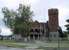
Whitehall Armory |
|
000000001995-03-02-0000March 2, 1995
(#95000079) |
62 Poultney St.
43°32′59″N 73°23′48″W / 43.549722°N 73.396667°W / 43.549722; -73.396667 (Whitehall Armory) |
Whitehall |
part of the Army National Guard Armories in New York State Multiple Property Submission (MPS)
|
| 50 |
Wing-Northup House |
|
000000002008-09-12-0000September 12, 2008
(#08000862) |
167 Broadway
43°16′10″N 73°35′14″W / 43.269528°N 73.587342°W / 43.269528; -73.587342 (Wing-Northup House) |
Fort Edward |
|

_in_2008.jpg)