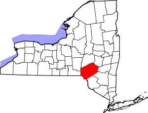
| [3] |
Name on the Register |
Image |
Date listed[4] |
Location |
City or town |
Description |
|---|
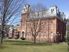
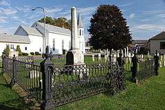
| 1 |
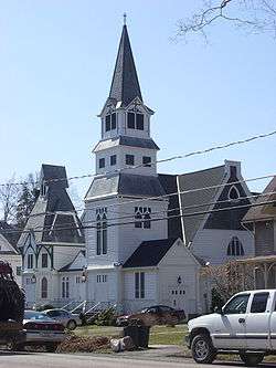
Andes Historic District |
Upload image |
000000001984-06-28-0000June 28, 1984
(#84002215) |
Delaware Ave., Main and High Sts., and Tremperskill Rd.
42°11′22″N 74°46′51″W / 42.189444°N 74.780833°W / 42.189444; -74.780833 (Andes Historic District) |
Andes |
|
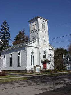
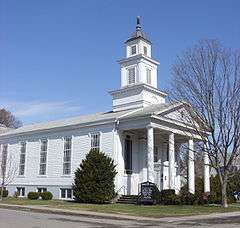
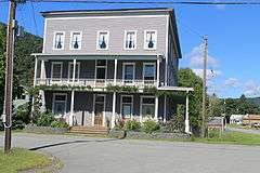
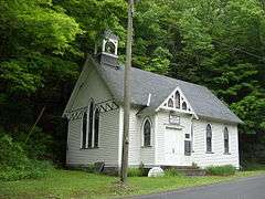
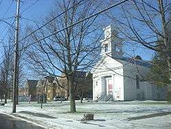
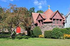
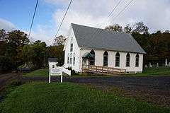
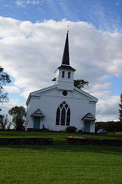
| 2 |
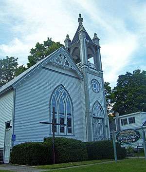
Bloomville Methodist Epicopal Church |
Upload image |
000000002006-11-29-0000November 29, 2006
(#06001080) |
35 Church St.
42°19′59″N 74°48′36″W / 42.333056°N 74.81°W / 42.333056; -74.81 (Bloomville Methodist Epicopal Church) |
Bloomville |
|
| 3 |
Bovina Center Historic District |
Upload image |
000000002000-06-02-0000June 2, 2000
(#00000574) |
Roughly Co. Rt. 6, Creamery Rd., Maple and Pink Sts.
42°15′34″N 74°47′20″W / 42.259444°N 74.788889°W / 42.259444; -74.788889 (Bovina Center Historic District) |
Bovina Center |
|
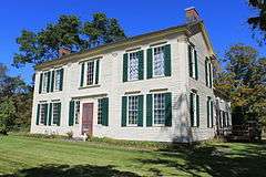
| 4 |
Amos Bristol Tavern |
Upload image |
000000002000-12-13-0000December 13, 2000
(#00001526) |
Cty Rte 14
42°20′55″N 75°00′51″W / 42.348611°N 75.014167°W / 42.348611; -75.014167 (Amos Bristol Tavern) |
West Meredith |
|
| 5 |
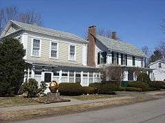
Burns Family Farm |
Upload image |
000000002007-05-30-0000May 30, 2007
(#07000486) |
Crescent Valley Rd.
42°17′59″N 74°40′48″W / 42.299794°N 74.680056°W / 42.299794; -74.680056 (Burns Family Farm) |
Bovina |
|
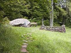
| 6 |
John Burroughs Home |
|
000000001966-10-15-0000October 15, 1966
(#66000512) |
2 mi. from Roxbury on Roxbury Rd.
42°17′47″N 74°35′03″W / 42.296389°N 74.584167°W / 42.296389; -74.584167 (John Burroughs Home) |
Roxbury |
A home of naturalist John Burroughs
|
| 7 |
Christ Episcopal Church |
|
000000001999-05-18-0000May 18, 1999
(#99000563) |
41 Gardiner Pl.
42°10′11″N 75°07′45″W / 42.169722°N 75.129167°W / 42.169722; -75.129167 (Christ Episcopal Church) |
Walton |
|
| 8 |
Christian Church |
Upload image |
000000002001-03-12-0000March 12, 2001
(#01000250) |
NY 10
42°17′56″N 74°52′45″W / 42.298889°N 74.879167°W / 42.298889; -74.879167 (Christian Church) |
East Delhi |
|
| 9 |
Churchill Park Historic District |
Upload image |
000000001980-11-17-0000November 17, 1980
(#80004609) |
NY 10 and NY 23 and W. Main St.
42°24′52″N 74°37′30″W / 42.414444°N 74.625°W / 42.414444; -74.625 (Churchill Park Historic District) |
Stamford |
|
| 10 |
Congregation Bnai Israel Synagogue |
|
000000002002-11-21-0000November 21, 2002
(#02001396) |
Wagner Ave.
42°09′19″N 74°31′59″W / 42.155278°N 74.533056°W / 42.155278; -74.533056 (Congregation Bnai Israel Synagogue) |
Fleischmanns |
1920 synagogue is only one listed in county and only one in Catskills with exposed truss roof
|
| 11 |
Delaware and Northern Railroad Station |
Upload image |
000000002004-08-20-0000August 20, 2004
(#04000872) |
Cabin Hill Rd.
42°11′14″N 74°47′21″W / 42.187222°N 74.789167°W / 42.187222; -74.789167 (Delaware and Northern Railroad Station) |
Andes |
|
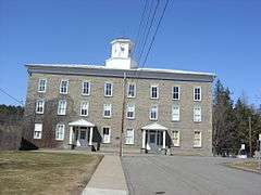
| 12 |
Delaware County Courthouse Square District |
|
000000001973-07-16-0000July 16, 1973
(#73001177) |
Roughly bounded by 2nd, Church, Main, and Court Sts.
42°16′42″N 74°55′01″W / 42.278333°N 74.916944°W / 42.278333; -74.916944 (Delaware County Courthouse Square District) |
Delhi |
|
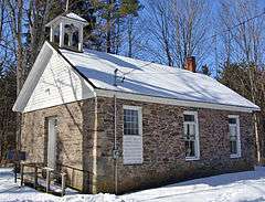
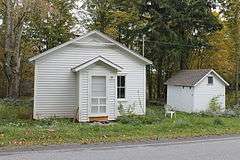
| 13 |
District 10 School |
|
000000001998-02-20-0000February 20, 1998
(#98000131) |
NY 28, 2 mi SW of Margaretville
42°07′20″N 74°40′32″W / 42.122222°N 74.675556°W / 42.122222; -74.675556 (District 10 School) |
Margaretville |
1820s school demolished in the 1850s, reassembled in 1860. Only building left standing in Pepacton Reservoir area
|
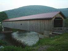
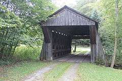
| 14 |
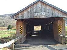
Downsville Covered Bridge |
|
000000001999-04-29-0000April 29, 1999
(#99000503) |
Bridge St.
42°04′34″N 74°59′28″W / 42.076111°N 74.991111°W / 42.076111; -74.991111 (Downsville Covered Bridge) |
Downsville |
|
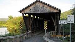
| 15 |
First Congregational Church of Walton |
|
000000002015-07-27-0000July 27, 2015
(#15000476) |
4 Mead St.
42°10′15″N 75°07′40″W / 42.170785°N 75.127784°W / 42.170785; -75.127784 (First Congregational Church of Walton) |
Walton |
1840s neoclassical church has long been an important part of the village
|
| 16 |
First Old School Baptist Church of Roxbury and Vega Cemetery |
Upload image |
000000001996-04-12-0000April 12, 1996
(#96000371) |
Near Jct. of Co. Rt. 36 and Cartwright Rd.
42°14′58″N 74°32′10″W / 42.249444°N 74.536111°W / 42.249444; -74.536111 (First Old School Baptist Church of Roxbury and Vega Cemetery) |
Roxbury |
|
| 17 |
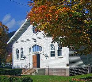
First Presbyterian Church |
|
000000002006-02-01-0000February 1, 2006
(#05001616) |
Clinton St.
42°16′28″N 74°55′21″W / 42.274444°N 74.9225°W / 42.274444; -74.9225 (First Presbyterian Church) |
Delhi |
|
| 18 |
First Presbyterian Church of Margaretville |
|
000000002004-04-21-0000April 21, 2004
(#04000348) |
169 Orchard Ave.
42°08′58″N 74°39′07″W / 42.149444°N 74.651944°W / 42.149444; -74.651944 (First Presbyterian Church of Margaretville) |
Margaretville |
Intact 1894 late Victorian church
|
| 19 |
Fitches Covered Bridge |
|
000000001999-04-29-0000April 29, 1999
(#99000508) |
Fitches Bridge Rd.
42°17′53″N 74°52′47″W / 42.298056°N 74.879722°W / 42.298056; -74.879722 (Fitches Covered Bridge) |
East Delhi |
|
| 20 |
Franklin Village Historic District |
|
000000001984-09-07-0000September 7, 1984
(#84002220) |
Wakeman and Institute Aves., Main, Center, Maple, Water, 2nd, 3rd, and West Sts.
42°20′24″N 75°09′58″W / 42.34°N 75.166111°W / 42.34; -75.166111 (Franklin Village Historic District) |
Franklin |
|
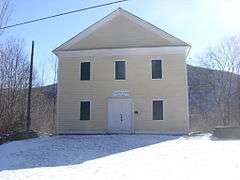
| 21 |
Judge Gideon Frisbee House |
|
000000001976-12-12-0000December 12, 1976
(#76001211) |
NE of Delhi on NY 10
42°17′57″N 74°53′29″W / 42.299167°N 74.891389°W / 42.299167; -74.891389 (Judge Gideon Frisbee House) |
Delhi |
|
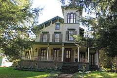
| 22 |
Amelita Galli-Curci Estate |
Upload image |
000000002010-08-19-0000August 19, 2010
(#10000556) |
352 and 374 Galli-Curci Road
42°08′21″N 74°32′09″W / 42.1391°N 74.5357°W / 42.1391; -74.5357 (Amelita Galli-Curci Estate) |
Fleischmanns vicinity |
New listing; refnum 10000556
|
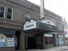
| 23 |
Galli-Curci Theatre |
|
000000002006-04-12-0000April 12, 2006
(#06000254) |
801 Main St.
42°08′56″N 74°38′56″W / 42.148889°N 74.648889°W / 42.148889; -74.648889 (Galli-Curci Theatre) |
Margaretville |
1922 movie theatre was also one of region's first car dealerships
|
| 24 |
Gardiner Place Historic District |
|
000000001984-05-24-0000May 24, 1984
(#84002222) |
Gardiner Place
42°10′08″N 75°07′43″W / 42.168889°N 75.128611°W / 42.168889; -75.128611 (Gardiner Place Historic District) |
Walton |
|
| 25 |
Hamden Covered Bridge |
|
000000001999-04-29-0000April 29, 1999
(#99000502) |
Basin Clove Rd.
42°11′44″N 74°59′19″W / 42.195556°N 74.988611°W / 42.195556; -74.988611 (Hamden Covered Bridge) |
Hamden |
|
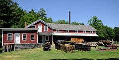
| 26 |
Hanford Mill |
|
000000001973-03-26-0000March 26, 1973
(#73001178) |
On CR 12
42°25′47″N 74°52′16″W / 42.429744°N 74.871097°W / 42.429744; -74.871097 (Hanford Mill) |
East Meredith |
|
| 27 |
Isaac Hardenbergh House |
Upload image |
000000001994-12-12-0000December 12, 1994
(#94001369) |
NY 23 N of jct. with William Lutz Rd.
42°20′14″N 74°27′11″W / 42.337222°N 74.453056°W / 42.337222; -74.453056 (Isaac Hardenbergh House) |
Roxbury |
|
| 28 |
Hobart Masonic Hall |
Upload image |
000000002001-12-28-0000December 28, 2001
(#01001399) |
6 Cornell Ave.
42°22′22″N 74°40′02″W / 42.372778°N 74.667222°W / 42.372778; -74.667222 (Hobart Masonic Hall) |
Hobart |
|
| 29 |
Hotel Delaware |
|
000000002004-12-06-0000December 6, 2004
(#04001342) |
391 Main St.
41°59′17″N 75°08′04″W / 41.988056°N 75.134444°W / 41.988056; -75.134444 (Hotel Delaware) |
East Branch |
|
| 30 |
Hubbell Family Farm and Kelly's Corners Cemetery |
Upload image |
000000002001-08-17-0000August 17, 2001
(#01000892) |
NY 30
42°11′25″N 74°35′40″W / 42.190278°N 74.594444°W / 42.190278; -74.594444 (Hubbell Family Farm and Kelly's Corners Cemetery) |
Kelly's Corners |
|
| 31 |
Jackson-Aitken Farm |
Upload image |
000000002003-02-20-0000February 20, 2003
(#03000044) |
3240 Fall Clove Rd.
42°09′28″N 74°52′10″W / 42.157778°N 74.869444°W / 42.157778; -74.869444 (Jackson-Aitken Farm) |
Andes |
|
| 32 |
Kelly Round Barn |
Upload image |
000000001984-09-29-0000September 29, 1984
(#84003857) |
NY 30
42°12′01″N 74°35′48″W / 42.200278°N 74.596667°W / 42.200278; -74.596667 (Kelly Round Barn) |
Halcottsville |
|
| 33 |
Lordville Presbyterian Church |
|
000000002000-02-04-0000February 4, 2000
(#00000052) |
Lordville Rd.
41°52′11″N 75°12′57″W / 41.869722°N 75.215833°W / 41.869722; -75.215833 (Lordville Presbyterian Church) |
Lordville |
|
| 34 |
Lower Shavertown Covered Bridge |
|
000000001999-04-29-0000April 29, 1999
(#99000504) |
682 Methol Rd.
41°55′24″N 75°00′49″W / 41.923333°N 75.013611°W / 41.923333; -75.013611 (Lower Shavertown Covered Bridge) |
Methol |
|
| 35 |
MacDonald Farm |
Upload image |
000000001973-04-03-0000April 3, 1973
(#73001179) |
Elk Creek and Monroe Rds.
42°21′14″N 74°51′44″W / 42.353889°N 74.862222°W / 42.353889; -74.862222 (MacDonald Farm) |
Meredith |
|
| 36 |
Main Street Historic District |
|
000000001988-02-29-0000February 29, 1988
(#88000111) |
Main St.
42°17′22″N 74°33′44″W / 42.289444°N 74.562222°W / 42.289444; -74.562222 (Main Street Historic District) |
Roxbury |
|
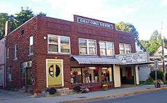
| 37 |
Maxbilt Theatre |
|
000000002014-12-10-0000December 10, 2014
(#14001019) |
932 Main St.
42°09′22″N 74°31′58″W / 42.156249°N 74.5327577°W / 42.156249; -74.5327577 (Maxbilt Theatre) |
Fleischmanns |
Small regional theater built in 1929 by Russian immigrant who went on to become a major regional developer during Catskill resort era; soon to be renovated into dinner theater
|
| 38 |
McArthur-Martin Hexadecagon Barn |
Upload image |
000000001984-09-29-0000September 29, 1984
(#84002237) |
McArthur Hill Rd.
42°22′18″N 74°46′51″W / 42.371667°N 74.780833°W / 42.371667; -74.780833 (McArthur-Martin Hexadecagon Barn) |
Bloomville |
|
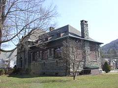
| 39 |
Murray Hill |
|
000000001982-06-03-0000June 3, 1982
(#82003354) |
Murray Hill Rd.
42°16′35″N 74°54′16″W / 42.276389°N 74.904444°W / 42.276389; -74.904444 (Murray Hill) |
Delhi |
|
| 40 |
New Kingston Historic District |
Upload image |
000000002008-02-19-0000February 19, 2008
(#08000037) |
Co. Rd. 6
42°12′52″N 74°40′53″W / 42.214556°N 74.681433°W / 42.214556; -74.681433 (New Kingston Historic District) |
New Kingston |
|
| 41 |
New Kingston Presbyterian Church |
Upload image |
000000002002-05-22-0000May 22, 2002
(#02000554) |
CR 6
42°12′48″N 74°40′57″W / 42.213333°N 74.6825°W / 42.213333; -74.6825 (New Kingston Presbyterian Church) |
New Kingston |
|
| 42 |
New Stone Hall |
|
000000001980-05-06-0000May 6, 1980
(#80002600) |
Center St.
42°20′20″N 75°10′06″W / 42.338889°N 75.168333°W / 42.338889; -75.168333 (New Stone Hall) |
Franklin |
|
| 43 |
Old School Baptist Church of Halcottsville |
Upload image |
000000001999-07-08-0000July 8, 1999
(#99000809) |
Old NY 30
42°12′25″N 74°36′05″W / 42.206944°N 74.601389°W / 42.206944; -74.601389 (Old School Baptist Church of Halcottsville) |
Halcottsville |
|
| 44 |
Pakatakan Artists Colony Historic District |
Upload image |
000000001989-02-21-0000February 21, 1989
(#89000046) |
NY 28 at jct. with Dry Brook Rd.
42°08′33″N 74°37′30″W / 42.1425°N 74.625°W / 42.1425; -74.625 (Pakatakan Artists Colony Historic District) |
Arkville |
|
| 45 |
Pioneer Cemetery |
|
000000002007-07-24-0000July 24, 2007
(#07000754) |
Main St.
42°18′59″N 75°23′39″W / 42.316389°N 75.394167°W / 42.316389; -75.394167 (Pioneer Cemetery) |
Sidney |
|
| 46 |
Ravina |
Upload image |
000000002000-02-04-0000February 4, 2000
(#00000048) |
Bouchouxville
41°52′16″N 75°12′28″W / 41.871111°N 75.207778°W / 41.871111; -75.207778 (Ravina) |
Lordville |
|
| 47 |
Rock Valley School |
|
000000002008-05-12-0000May 12, 2008
(#08000406) |
9598 Rock Valley Rd.
41°53′33″N 75°05′04″W / 41.892364°N 75.084436°W / 41.892364; -75.084436 (Rock Valley School) |
Rock Valley |
(new listing; refnum 08000406)
|
| 48 |
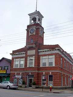
Second Walton Armory (33rd Separate Company) |
Upload image |
000000002016-09-06-0000September 6, 2016
(#16000591) |
139 Stockton Ave.
Coordinates missing |
Walton |
1890s armory by Isaac Perry now known as Castle on the Hudson, used as restaurant, events center
|
| 49 |
St. John's Church Complex |
|
000000001995-07-21-0000July 21, 1995
(#95000879) |
136 Main St.
42°16′45″N 74°55′00″W / 42.279167°N 74.916667°W / 42.279167; -74.916667 (St. John's Church Complex) |
Delhi |
|
| 50 |
St. Peter's Episcopal Church Complex |
Upload image |
000000001998-07-31-0000July 31, 1998
(#98000948) |
Jct. of Pine and Church Sts.
42°22′13″N 74°40′13″W / 42.370278°N 74.670278°W / 42.370278; -74.670278 (St. Peter's Episcopal Church Complex) |
Hobart |
|
| 51 |
Schoolhouse No. 5 |
|
000000002011-06-01-0000June 1, 2011
(#11000326) |
5942 Dunk Hill Rd.
42°16′05″N 75°05′08″W / 42.268056°N 75.085556°W / 42.268056; -75.085556 (Schoolhouse No. 5) |
Hamden vicinity |
New listing; refnum 11000326
|
| 52 |
Second Old School Baptist Church of Roxbury |
|
000000001999-07-28-0000July 28, 1999
(#99000908) |
Cty. Rd. 41
42°15′53″N 74°35′43″W / 42.264722°N 74.595278°W / 42.264722; -74.595278 (Second Old School Baptist Church of Roxbury) |
Roxbury |
|
| 53 |
Erskine L. Seeley House |
Upload image |
000000002010-08-30-0000August 30, 2010
(#10000593) |
46 Main St.
42°24′28″N 74°36′48″W / 42.407778°N 74.613333°W / 42.407778; -74.613333 (Erskine L. Seeley House) |
Stamford |
New listing; refnum 10000593
|
| 54 |
Sherwood Family Estate |
Upload image |
000000002002-12-31-0000December 31, 2002
(#02001648) |
484 Sherwood Rd.
42°15′50″N 74°56′03″W / 42.263889°N 74.934167°W / 42.263889; -74.934167 (Sherwood Family Estate) |
Delhi |
|
| 55 |
Sidney Historic District |
|
000000002013-09-04-0000September 4, 2013
(#13000679) |
Railroad Ave., River, Bridge & Main Sts.
42°18′57″N 75°23′42″W / 42.3159419°N 75.3949437°W / 42.3159419; -75.3949437 (Sidney Historic District) |
Sidney |
|
| 56 |
Skene Memorial Library |
|
000000002001-05-30-0000May 30, 2001
(#01000576) |
Main St.-Old NY 28
42°09′19″N 74°31′46″W / 42.155278°N 74.529444°W / 42.155278; -74.529444 (Skene Memorial Library) |
Fleischmanns |
Queen Anne/Shingle Style Carnegie library built by Alexander Skene's widow in his memory in 1901
|
| 57 |
Walter Stratton House |
Upload image |
000000002002-12-31-0000December 31, 2002
(#02001660) |
New Kingston Mountain Rd.
42°15′21″N 74°37′00″W / 42.255833°N 74.616667°W / 42.255833; -74.616667 (Walter Stratton House) |
Roxbury |
|
| 58 |
Thomson Family Farm |
Upload image |
000000002004-09-15-0000September 15, 2004
(#04001000) |
Thomson Hollow Rd.
42°16′03″N 74°38′03″W / 42.2675°N 74.634167°W / 42.2675; -74.634167 (Thomson Family Farm) |
New Kingston |
|
| 59 |
Ulster and Delaware Railroad Depot and Mill Complex |
|
000000002003-04-18-0000April 18, 2003
(#03000254) |
Depot St.
42°17′04″N 74°34′11″W / 42.284444°N 74.569722°W / 42.284444; -74.569722 (Ulster and Delaware Railroad Depot and Mill Complex) |
Roxbury |
|
| 60 |
Union Free School |
|
000000002004-12-06-0000December 6, 2004
(#04001345) |
218 NY 206
42°04′59″N 74°59′53″W / 42.083056°N 74.998056°W / 42.083056; -74.998056 (Union Free School) |
Downsville |
|
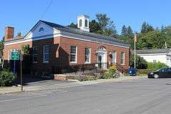
| 61 |
US Post Office-Delhi |
|
000000001988-11-17-0000November 17, 1988
(#88002477) |
10 Court St.
42°16′40″N 74°55′07″W / 42.277778°N 74.918611°W / 42.277778; -74.918611 (US Post Office-Delhi) |
Delhi |
|
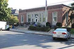
| 62 |
US Post Office-Walton |
|
000000001989-05-11-0000May 11, 1989
(#88002439) |
34-36 Gardner Pl.
42°10′09″N 75°07′42″W / 42.169167°N 75.128333°W / 42.169167; -75.128333 (US Post Office-Walton) |
Walton |
|
| 63 |
Van Benschoten House and Guest House |
Upload image |
000000002002-04-01-0000April 1, 2002
(#02000302) |
Margaretville Mountain Rd.
42°10′02″N 74°40′08″W / 42.167222°N 74.668889°W / 42.167222; -74.668889 (Van Benschoten House and Guest House) |
Margaretville |
|
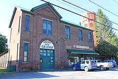
| 64 |
Walton Grange 1454-Former Armory |
|
000000001998-06-22-0000June 22, 1998
(#98000666) |
57 Stockton Ave.
42°09′56″N 75°07′50″W / 42.165556°N 75.130556°W / 42.165556; -75.130556 (Walton Grange 1454-Former Armory) |
Walton |
|
| 65 |
West Delhi Presbyterian Church, Manse, and Cemetery |
|
000000002008-11-07-0000November 7, 2008
(#08001032) |
18 and 45 Sutherland Rd.
42°18′00″N 75°00′25″W / 42.300114°N 75.007025°W / 42.300114; -75.007025 (West Delhi Presbyterian Church, Manse, and Cemetery) |
West Delhi |
New listing; refnum#08001032
|
| 66 |
West Kortright Presbyterian Church |
|
000000002002-11-15-0000November 15, 2002
(#02001326) |
49 W. Kortright Church Rd.
42°24′08″N 74°51′08″W / 42.402222°N 74.852222°W / 42.402222; -74.852222 (West Kortright Presbyterian Church) |
West Kortright |
|
| 67 |
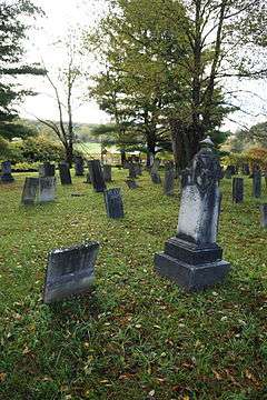
West Meredith Cemetery |
|
000000002003-11-07-0000November 7, 2003
(#03001119) |
Cty Rte. 14
42°20′48″N 75°01′36″W / 42.346667°N 75.026667°W / 42.346667; -75.026667 (West Meredith Cemetery) |
West Meredith |
|