| [3] |
Name on the Register |
Image |
Date listed[4] |
Location |
City or town |
Description |
|---|
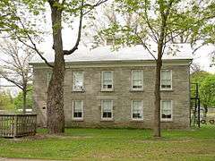
| 1 |
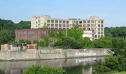
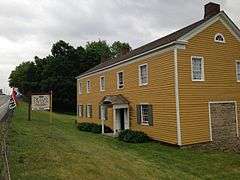
Ames Academy Building |
|
000000002002-01-24-0000January 24, 2002
(#01001496) |
611 Latimer Hill Rd.
42°50′13″N 74°36′00″W / 42.836944°N 74.6°W / 42.836944; -74.6 (Ames Academy Building) |
Ames |
|
| 2 |
Amsterdam (46th Separate Company) Armory |
|
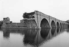
000000001994-07-01-0000July 1, 1994
(#94000658) |
Junction of Florida Ave. and Dewitt St., southwest corner
42°55′58″N 74°11′59″W / 42.932778°N 74.199722°W / 42.932778; -74.199722 (Amsterdam (46th Separate Company) Armory) |
Amsterdam |
|
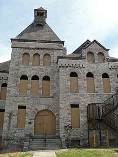
| 3 |
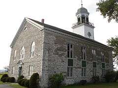
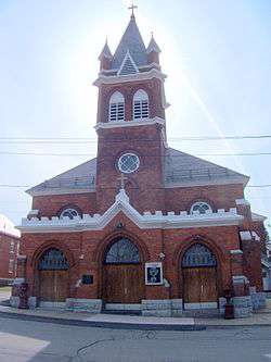
Amsterdam City Hall |
Upload image |
000000002001-02-05-0000February 5, 2001
(#00001687) |
61 Church St.
42°56′21″N 74°15′45″W / 42.939167°N 74.2625°W / 42.939167; -74.2625 (Amsterdam City Hall) |
Amsterdam |
|
| 4 |
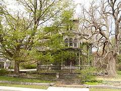
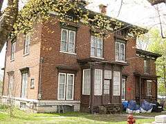
Bates-Englehardt Mansion |
|
000000001989-12-07-0000December 7, 1989
(#89002091) |
19 Washington St.
42°59′59″N 74°40′38″W / 42.999722°N 74.677222°W / 42.999722; -74.677222 (Bates-Englehardt Mansion) |
St. Johnsville |
|
| 5 |
Bragdon-Lipe House |
|
000000002005-10-05-0000October 5, 2005
(#05001123) |
17 Otsego St.
42°54′14″N 74°34′28″W / 42.903889°N 74.574444°W / 42.903889; -74.574444 (Bragdon-Lipe House) |
Canajoharie |
|
| 6 |
Walter Butler Homestead |
Upload image |
000000001976-06-23-0000June 23, 1976
(#76001229) |
Northeast of Fonda on Old Trail Rd.
42°57′43″N 74°21′17″W / 42.961944°N 74.354722°W / 42.961944; -74.354722 (Walter Butler Homestead) |
Fonda |
|
| 7 |
Canajoharie Historic District |
|
000000002015-05-18-0000May 18, 2015
(#15000233) |
Roughly Church, Cliff, E. and W. Main, Mill, Moyer, Rock, and Reed Sts., and Erie Boulevard
42°54′11″N 74°34′16″W / 42.90306°N 74.57111°W / 42.90306; -74.57111 (Canajoharie Historic District) |
Canajoharie |
Historic Mohawk Valley village
|
| 8 |
Caughnawaga Indian Village Site |
|
000000001973-08-28-0000August 28, 1973
(#73001207) |
Address Restricted
42°57′07″N 74°23′26″W / 42.95181°N 74.390551°W / 42.95181; -74.390551 (Caughnawaga Indian Village Site) |
Fonda |
|
| 9 |
Chalmers Knitting Mills |
|
000000002010-02-22-0000February 22, 2010
(#10000028) |
21-41 Bridge St.
42°56′07″N 74°11′47″W / 42.935385°N 74.196444°W / 42.935385; -74.196444 (Chalmers Knitting Mills) |
Amsterdam |
|
| 10 |
Ehle House Site |
Upload image |
000000001982-06-14-0000June 14, 1982
(#82004780) |
Address Restricted
|
Nelliston |
|
| 11 |
Peter Ehle House |
Upload image |
000000001980-09-27-0000September 27, 1980
(#80002655) |
E. Main St.
42°55′24″N 74°36′05″W / 42.923333°N 74.601389°W / 42.923333; -74.601389 (Peter Ehle House) |
Nelliston |
|
| 12 |
Enlarged Double Lock No. 33 Old Erie Canal |
Upload image |
000000002002-04-01-0000April 1, 2002
(#02000315) |
Towpath Rd.
42°59′26″N 74°40′02″W / 42.990556°N 74.667222°W / 42.990556; -74.667222 (Enlarged Double Lock No. 33 Old Erie Canal) |
St. Johnsville |
|
| 13 |
Erie Canal |
|
000000001966-10-15-0000October 15, 1966
(#66000530) |
6 miles (9.7 km) west of Amsterdam on NY 5S
42°56′38″N 74°16′02″W / 42.943889°N 74.267222°W / 42.943889; -74.267222 (Erie Canal) |
Fort Hunter |
Ruins of Erie Canal aqueduct over Schoharie Creek, and 3.5 mile segment of canal
|
| 14 |
First Baptist Church |
|
000000001994-01-21-0000January 21, 1994
(#93001546) |
Polin Rd.
42°50′55″N 74°20′43″W / 42.848611°N 74.345278°W / 42.848611; -74.345278 (First Baptist Church) |
Charleston |
|
| 15 |
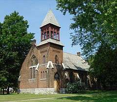
First Methodist Episcopal Church of St. Johnsville |
|
000000002013-02-05-0000February 5, 2013
(#12001259) |
5 W. Main St.
42°59′55″N 74°40′45″W / 42.998645°N 74.679299°W / 42.998645; -74.679299 (First Methodist Episcopal Church of St. Johnsville) |
St. Johnsville |
|
| 16 |
Fort Johnson |
|
000000001972-11-28-0000November 28, 1972
(#72000858) |
Junction of NY 5 and NY 67
42°57′30″N 74°14′00″W / 42.958333°N 74.233333°W / 42.958333; -74.233333 (Fort Johnson) |
Fort Johnson |
|
| 17 |
Fort Klock |
|
000000001972-11-28-0000November 28, 1972
(#72000859) |
2 miles (3.2 km) east of St. Johnsville on NY 5
42°59′06″N 74°39′01″W / 42.985°N 74.650278°W / 42.985; -74.650278 (Fort Klock) |
St. Johnsville |
|
| 18 |
Fort Plain Conservation Area |
Upload image |
000000001979-11-15-0000November 15, 1979
(#79001591) |
Address Restricted
|
Fort Plain |
|
| 19 |
Fort Plain Historic District |
|
000000002012-08-15-0000August 15, 2012
(#12000510) |
Roughly area around Canal & Main Sts.
42°55′51″N 74°37′22″W / 42.930851°N 74.622887°W / 42.930851; -74.622887 (Fort Plain Historic District) |
Fort Plain |
|
| 20 |
Frey House |
|
000000002002-12-31-0000December 31, 2002
(#02001644) |
NY 5
42°54′43″N 74°35′04″W / 42.911944°N 74.584444°W / 42.911944; -74.584444 (Frey House) |
Palatine Bridge |
|
| 21 |
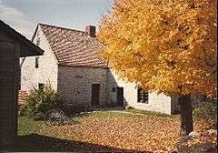
Caspar Getman Farmstead |
Upload image |
000000002010-08-30-0000August 30, 2010
(#10000594) |
1311 Stone Arabia Rd.
42°57′50″N 74°30′43″W / 42.963889°N 74.511944°W / 42.963889; -74.511944 (Caspar Getman Farmstead) |
Stone Arabia |
|
| 22 |
Glen Historic District |
|
000000002001-08-08-0000August 8, 2001
(#01000844) |
NY 30A, NY 161 and Logtown Rd.
42°53′40″N 74°20′33″W / 42.894444°N 74.3425°W / 42.894444; -74.3425 (Glen Historic District) |
Glen |
|
| 23 |
Gray-Jewett House |
Upload image |
000000002005-10-05-0000October 5, 2005
(#05001127) |
80 Florida Ave.
42°56′01″N 74°12′00″W / 42.933611°N 74.2°W / 42.933611; -74.2 (Gray-Jewett House) |
Amsterdam |
|
| 24 |
Green Hill Cemetery |
Upload image |
000000002005-03-15-0000March 15, 2005
(#05000166) |
Church and Cornell Sts.
42°56′16″N 74°11′05″W / 42.937778°N 74.184722°W / 42.937778; -74.184722 (Green Hill Cemetery) |
Amsterdam |
|
| 25 |
Greene Mansion |
|
000000001979-12-31-0000December 31, 1979
(#79001590) |
92 Market St.
42°56′24″N 74°11′27″W / 42.94°N 74.190833°W / 42.94; -74.190833 (Greene Mansion) |
Amsterdam |
|
| 26 |
Guy Park |
|
000000001973-02-06-0000February 6, 1973
(#73001206) |
W. Main St.
42°56′49″N 74°12′36″W / 42.946944°N 74.21°W / 42.946944; -74.21 (Guy Park) |
Amsterdam |
|
| 27 |
Guy Park Avenue School |
Upload image |
000000001995-06-02-0000June 2, 1995
(#95000669) |
300 Guy Park Ave.
42°56′59″N 74°12′31″W / 42.949722°N 74.208611°W / 42.949722; -74.208611 (Guy Park Avenue School) |
Amsterdam |
|
| 28 |
Hurricana Stock Farm |
Upload image |
000000002013-05-22-0000May 22, 2013
(#13000308) |
NY 30
42°57′30″N 74°11′08″W / 42.9584545627494°N 74.18557879709256°W / 42.9584545627494; -74.18557879709256 (Hurricana Stock Farm) |
Amsterdam |
|
| 29 |
Samuel and Johanna Jones Farm |
Upload image |
000000001993-05-27-0000May 27, 1993
(#93000460) |
NY 67 west of the junction with NY 296
42°57′51″N 74°06′29″W / 42.964167°N 74.108056°W / 42.964167; -74.108056 (Samuel and Johanna Jones Farm) |
Amsterdam |
|
| 30 |
Kilts Farmstead |
Upload image |
000000002009-09-18-0000September 18, 2009
(#09000721) |
Address restricted
|
Stone Arabia |
|
| 31 |
Lasher-Davis House |
Upload image |
000000001980-09-27-0000September 27, 1980
(#80002656) |
U.S. 5
42°56′09″N 74°36′55″W / 42.935833°N 74.615278°W / 42.935833; -74.615278 (Lasher-Davis House) |
Nelliston |
|
| 32 |
Nellis Tavern |
|
000000001990-05-10-0000May 10, 1990
(#90000685) |
SR 5
42°59′37″N 74°39′33″W / 42.993611°N 74.659167°W / 42.993611; -74.659167 (Nellis Tavern) |
St. Johnsville |
|
| 33 |
Jacob Nellis Farmhouse |
Upload image |
000000001980-09-27-0000September 27, 1980
(#80002657) |
Nellis St.
42°56′00″N 74°36′27″W / 42.933333°N 74.6075°W / 42.933333; -74.6075 (Jacob Nellis Farmhouse) |
Nelliston |
|
| 34 |
Nelliston Historic District |
|
000000001980-09-27-0000September 27, 1980
(#80002658) |
Prospect, River, Railroad and Berthoud Sts.
42°56′02″N 74°37′00″W / 42.933889°N 74.616667°W / 42.933889; -74.616667 (Nelliston Historic District) |
Nelliston |
|
| 35 |
Nelliston School |
Upload image |
000000002002-12-31-0000December 31, 2002
(#02001645) |
Stone Arabia St.
42°56′08″N 74°36′49″W / 42.935556°N 74.613611°W / 42.935556; -74.613611 (Nelliston School) |
Nelliston |
|
| 36 |
New York State Barge Canal |
|
000000002014-10-15-0000October 15, 2014
(#14000860) |
Linear across county
Coordinates missing |
Amsterdam, Canajoharie, Fonda, Glen, Minden, Mohawk, Palatine and St. Johnsville |
Successor to Erie Canal approved by state voters in early 20th century to compete with railroads
|
| 37 |
Palatine Bridge Freight House |
Upload image |
000000001973-03-07-0000March 7, 1973
(#73001208) |
East of Palatine Bridge on NY 5
42°54′36″N 74°33′59″W / 42.91°N 74.566389°W / 42.91; -74.566389 (Palatine Bridge Freight House) |
Palatine Bridge |
|
| 38 |
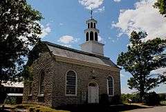
Palatine Church |
|
000000001973-01-25-0000January 25, 1973
(#73001209) |
Mohawk Tpke.
42°58′08″N 74°37′44″W / 42.968889°N 74.628889°W / 42.968889; -74.628889 (Palatine Church) |
Palatine |
|
| 39 |
Pawling Hall |
Upload image |
000000002002-11-15-0000November 15, 2002
(#02001331) |
86 Pawling St.
42°58′39″N 74°09′07″W / 42.9775°N 74.151944°W / 42.9775; -74.151944 (Pawling Hall) |
Hagaman |
|
| 40 |
Margaret Reaney Memorial Library |
Upload image |
000000002012-04-16-0000April 16, 2012
(#12000210) |
19 Kingsbury Ave.
42°59′49″N 74°40′38″W / 42.997067°N 74.677209°W / 42.997067; -74.677209 (Margaret Reaney Memorial Library) |
St. Johnsville |
|
| 41 |
Reformed Dutch Church of Stone Arabia |
|
000000001977-09-14-0000September 14, 1977
(#77000951) |
East of Nelliston on NY 10
42°56′33″N 74°33′24″W / 42.9425°N 74.556667°W / 42.9425; -74.556667 (Reformed Dutch Church of Stone Arabia) |
Nelliston |
|
| 42 |
Rice's Woods |
Upload image |
000000001980-07-18-0000July 18, 1980
(#80002654) |
Address Restricted
|
Canajoharie |
|
| 43 |
John Smith Farm |
Upload image |
000000002012-01-31-0000January 31, 2012
(#11001061) |
1059 NY 80
42°56′08″N 74°42′17″W / 42.935683°N 74.704717°W / 42.935683; -74.704717 (John Smith Farm) |
Hallsville |
|
| 44 |
Saint Stanislaus Roman Catholic Church Complex |
|
000000001999-04-29-0000April 29, 1999
(#99000505) |
42, 46, 50 Cornell St., 73 Reid St.
42°56′39″N 74°10′58″W / 42.944167°N 74.182778°W / 42.944167; -74.182778 (Saint Stanislaus Roman Catholic Church Complex) |
Amsterdam |
|
| 45 |
Stone Grist Mill Complex |
Upload image |
000000001996-02-23-0000February 23, 1996
(#96000140) |
1679 Mill Rd.
43°00′17″N 74°41′47″W / 43.004722°N 74.696389°W / 43.004722; -74.696389 (Stone Grist Mill Complex) |
St. Johnsville |
|
| 46 |
Samuel Sweet Canal Store |
Upload image |
000000001989-09-19-0000September 19, 1989
(#89001389) |
65 Bridge St.
42°56′04″N 74°11′54″W / 42.934444°N 74.198333°W / 42.934444; -74.198333 (Samuel Sweet Canal Store) |
Amsterdam |
|
| 47 |
Temple of Israel |
|
000000001992-08-27-0000August 27, 1992
(#92001043) |
8 Mohawk Pl.
42°56′22″N 74°11′41″W / 42.939444°N 74.194722°W / 42.939444; -74.194722 (Temple of Israel) |
Amsterdam |
|
| 48 |
Trinity Lutheran Church and Cemetery |
|
000000002005-01-05-0000January 5, 2005
(#04001440) |
5430 NY 10
42°56′28″N 74°33′46″W / 42.941111°N 74.562778°W / 42.941111; -74.562778 (Trinity Lutheran Church and Cemetery) |
Stone Arabia |
|
| 49 |
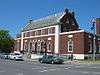
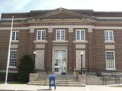
US Post Office-Amsterdam |
|
000000001988-11-17-0000November 17, 1988
(#88002451) |
12-16 Church St.
42°56′14″N 74°11′31″W / 42.937222°N 74.191944°W / 42.937222; -74.191944 (US Post Office-Amsterdam) |
Amsterdam |
|
| 50 |
US Post Office-Canajoharie |
Upload image |
000000001988-11-17-0000November 17, 1988
(#88002464) |
50 W. Main St.
42°54′23″N 74°33′41″W / 42.906389°N 74.561389°W / 42.906389; -74.561389 (US Post Office-Canajoharie) |
Canajoharie |
|
| 51 |
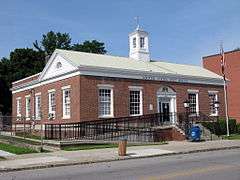
US Post Office-Fort Plain |
|
000000001989-05-11-0000May 11, 1989
(#88002510) |
41 River St.
42°55′54″N 74°37′23″W / 42.931667°N 74.623056°W / 42.931667; -74.623056 (US Post Office-Fort Plain) |
Fort Plain |
|
| 52 |
US Post Office-St. Johnsville |
|
000000001989-05-11-0000May 11, 1989
(#88002434) |
15 E. Main St.[5]
42°59′55″N 74°40′42″W / 42.998611°N 74.678333°W / 42.998611; -74.678333 (US Post Office-St. Johnsville) |
St. Johnsville |
|
| 53 |
Van Alstyne House |
|
000000001983-09-08-0000September 8, 1983
(#83001711) |
Moyer St.
42°54′12″N 74°34′22″W / 42.903333°N 74.572778°W / 42.903333; -74.572778 (Van Alstyne House) |
Canajoharie |
|
| 54 |
Van Wie Farmstead |
Upload image |
000000002011-07-14-0000July 14, 2011
(#11000450) |
269 Brower Rd.
42°54′10″N 74°31′31″W / 42.902778°N 74.525278°W / 42.902778; -74.525278 (Van Wie Farmstead) |
McKinley |
|
| 55 |
Vrooman Avenue School |
Upload image |
000000001983-06-30-0000June 30, 1983
(#83001712) |
Vrooman Ave.
42°56′08″N 74°10′30″W / 42.935556°N 74.175°W / 42.935556; -74.175 (Vrooman Avenue School) |
Amsterdam |
|
| 56 |
Webster Wagner House |
|
000000001973-03-07-0000March 7, 1973
(#73001210) |
E. Grand St.
42°54′39″N 74°34′10″W / 42.910833°N 74.569444°W / 42.910833; -74.569444 (Webster Wagner House) |
Palatine Bridge |
|
| 57 |
Walrath-Van Horne House |
Upload image |
000000001980-09-27-0000September 27, 1980
(#80002659) |
W. Main St.
42°56′29″N 74°37′08″W / 42.941389°N 74.618889°W / 42.941389; -74.618889 (Walrath-Van Horne House) |
Nelliston |
|
| 58 |
Waterman-Gramps House |
Upload image |
000000001980-09-27-0000September 27, 1980
(#80002660) |
School St.
42°56′13″N 74°36′45″W / 42.936944°N 74.6125°W / 42.936944; -74.6125 (Waterman-Gramps House) |
Nelliston |
|
| 59 |
West Hill School |
|
000000002002-04-11-0000April 11, 2002
(#02000359) |
3 Otsego St.
42°54′17″N 74°34′25″W / 42.904722°N 74.573611°W / 42.904722; -74.573611 (West Hill School) |
Canajoharie |
|
| 60 |
Windfall Dutch Barn |
Upload image |
000000002000-11-22-0000November 22, 2000
(#00001411) |
Clinton Rd. at the junction with Ripple Rd.
42°51′32″N 74°44′40″W / 42.858889°N 74.744444°W / 42.858889; -74.744444 (Windfall Dutch Barn) |
Salt Springville |
|

.jpg)


%2C_Palatine_Bridge_(Montgomery_County%2C_New_York).jpg)


.jpg)

.jpg)
.jpg)