| [3] |
Name on the Register |
Image |
Date listed[4] |
Location |
City or town |
Description |
|---|
| 1 |
Angus Cobblestone Farmhouse and Barn Complex |
Upload image |
000000001992-05-11-0000May 11, 1992
(#92000439) |
612 NY 14
42°44′03″N 76°58′29″W / 42.734167°N 76.974722°W / 42.734167; -76.974722 (Angus Cobblestone Farmhouse and Barn Complex) |
Benton |
|
| 2 |
Jonathan Bailey House |
Upload image |
000000001994-08-24-0000August 24, 1994
(#94000926) |
Bath Rd.
42°35′22″N 77°03′34″W / 42.589444°N 77.059444°W / 42.589444; -77.059444 (Jonathan Bailey House) |
Milo |
|
| 3 |
Barden Cobblestone Farmhouse |
Upload image |
000000001992-05-11-0000May 11, 1992
(#92000435) |
2492 Ferguson Corners Rd.
42°45′16″N 77°04′26″W / 42.754444°N 77.073889°W / 42.754444; -77.073889 (Barden Cobblestone Farmhouse) |
Benton |
|
| 4 |
Bates Cobblestone Farmhouse |
Upload image |
000000001992-05-11-0000May 11, 1992
(#92000436) |
5521 NY 364
42°45′34″N 77°16′25″W / 42.759444°N 77.273611°W / 42.759444; -77.273611 (Bates Cobblestone Farmhouse) |
Middlesex |
|
| 5 |
Beddoe–Rose Family Cemetery |
Upload image |
000000002014-11-19-0000November 19, 2014
(#14000939) |
E. of W. Bluff Dr., Keuka Lake State Park
42°34′57″N 77°07′55″W / 42.58249341284871°N 77.13193645908692°W / 42.58249341284871; -77.13193645908692 (Beddoe–Rose Family Cemetery) |
Jerusalem |
Grave sites of family involved in early settlement of area
|
| 6 |
Peter Bitley House |
Upload image |
000000001994-08-24-0000August 24, 1994
(#94000927) |
W. Lake Rd. (NY Rt. 54A)
42°35′32″N 77°09′11″W / 42.592222°N 77.153056°W / 42.592222; -77.153056 (Peter Bitley House) |
Jerusalem |
|
| 7 |
Thomas Bitley House |
Upload image |
000000001994-08-24-0000August 24, 1994
(#94000928) |
Lake St.
42°35′33″N 77°09′10″W / 42.5925°N 77.152778°W / 42.5925; -77.152778 (Thomas Bitley House) |
Jerusalem |
|
| 8 |
Samuel Botsford House |
Upload image |
000000001994-08-24-0000August 24, 1994
(#94000929) |
County House Rd.
42°37′46″N 77°09′41″W / 42.629444°N 77.161389°W / 42.629444; -77.161389 (Samuel Botsford House) |
Jerusalem |
|
| 9 |
John Briggs House |
Upload image |
000000001994-08-24-0000August 24, 1994
(#94000930) |
2646 Himrod Rd.
42°38′07″N 77°00′01″W / 42.635278°N 77.000278°W / 42.635278; -77.000278 (John Briggs House) |
Milo Center |
|
| 10 |
John Carr House |
Upload image |
000000001994-08-24-0000August 24, 1994
(#94000931) |
NY 245
42°41′46″N 77°16′40″W / 42.696111°N 77.277778°W / 42.696111; -77.277778 (John Carr House) |
Middlesex |
|
| 11 |
Crooked Lake Outlet Historic District |
Upload image |
000000001996-01-19-0000January 19, 1996
(#95001545) |
Along the Keuka Lake Outlet Trail, from Penn Yan to Dresden
42°40′37″N 76°57′49″W / 42.676944°N 76.963611°W / 42.676944; -76.963611 (Crooked Lake Outlet Historic District) |
Penn Yan |
|
| 12 |
Thomas Bennett Curtis House |
Upload image |
000000001994-08-24-0000August 24, 1994
(#94000932) |
Shannon Corners Rd.
42°33′00″N 76°55′53″W / 42.55°N 76.931389°W / 42.55; -76.931389 (Thomas Bennett Curtis House) |
Starkey |
|
| 13 |
Dundee Methodist Church |
|
000000002005-01-05-0000January 5, 2005
(#04001445) |
33 Water St.
42°31′35″N 76°58′36″W / 42.526389°N 76.976667°W / 42.526389; -76.976667 (Dundee Methodist Church) |
Dundee |
|
| 14 |
Dundee Village Historic District |
|
000000002007-04-10-0000April 10, 2007
(#07000329) |
Main, Water, and Seneca Sts.
42°31′24″N 76°58′37″W / 42.523386°N 76.976872°W / 42.523386; -76.976872 (Dundee Village Historic District) |
Dundee |
|
| 15 |
Jephtha Earl Cobblestone Farmhouse |
Upload image |
000000001992-05-11-0000May 11, 1992
(#92000438) |
Old State Rd. N of jct. with Johnson Rd.
42°45′27″N 76°58′42″W / 42.7575°N 76.978333°W / 42.7575; -76.978333 (Jephtha Earl Cobblestone Farmhouse) |
Benton |
|
| 16 |
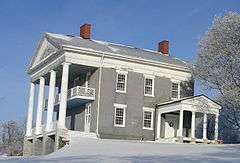
Esperanza |
Upload image |
000000001995-12-07-0000December 7, 1995
(#95001406) |
NY 54A E of Keuka Lake
42°35′45″N 77°08′06″W / 42.595833°N 77.135°W / 42.595833; -77.135 (Esperanza) |
Jerusalem |
|
| 17 |
First Presbyterian Church |
|
000000002004-09-24-0000September 24, 2004
(#04001058) |
31 Main St.
42°31′28″N 76°58′37″W / 42.524444°N 76.976944°W / 42.524444; -76.976944 (First Presbyterian Church) |
Dundee |
|
| 18 |
James Fox House |
Upload image |
000000001994-08-24-0000August 24, 1994
(#94000934) |
750 Italy Valley Rd.
42°36′22″N 77°17′54″W / 42.606111°N 77.298333°W / 42.606111; -77.298333 (James Fox House) |
Italy |
|
| 19 |
Garrett Memorial Chapel |
|
000000002001-03-30-0000March 30, 2001
(#01000296) |
Skyline Dr.
42°30′27″N 77°07′54″W / 42.5075°N 77.131667°W / 42.5075; -77.131667 (Garrett Memorial Chapel) |
Jerusalem |
|
| 20 |
Asahel Green Farm |
Upload image |
000000001994-08-24-0000August 24, 1994
(#94000935) |
S. Vine Valley Rd.
42°43′40″N 77°18′00″W / 42.727778°N 77.3°W / 42.727778; -77.3 (Asahel Green Farm) |
Middlesex |
|
| 21 |
Uriah Hair House |
Upload image |
000000001994-08-24-0000August 24, 1994
(#94000936) |
Water St. (Dundee-Himrod Rd.)
42°31′52″N 76°58′32″W / 42.531111°N 76.975556°W / 42.531111; -76.975556 (Uriah Hair House) |
Dundee |
|
| 22 |
Hampstead |
Upload image |
000000001994-08-24-0000August 24, 1994
(#94000937) |
3170 NY Rt. 54A
42°36′14″N 77°06′48″W / 42.603889°N 77.113333°W / 42.603889; -77.113333 (Hampstead) |
Jerusalem |
|
| 23 |
Uriah Hanford House |
Upload image |
000000001994-08-24-0000August 24, 1994
(#94000938) |
W. Lake Rd.
42°39′12″N 77°04′35″W / 42.653333°N 77.076389°W / 42.653333; -77.076389 (Uriah Hanford House) |
Jerusalem |
|
| 24 |
George Hays House |
Upload image |
000000001994-08-24-0000August 24, 1994
(#94000939) |
County House Rd.
42°40′01″N 77°04′26″W / 42.666944°N 77.073889°W / 42.666944; -77.073889 (George Hays House) |
Jerusalem |
|
| 25 |
Himrod Baptist Church |
Upload image |
000000001994-08-24-0000August 24, 1994
(#94000940) |
Himrod Rd.
42°35′22″N 76°57′17″W / 42.589444°N 76.954722°W / 42.589444; -76.954722 (Himrod Baptist Church) |
Milo |
|
| 26 |
James Hobart House |
Upload image |
000000001994-08-24-0000August 24, 1994
(#94000941) |
4646 Italy Valley Rd.
42°41′39″N 77°12′47″W / 42.694167°N 77.213056°W / 42.694167; -77.213056 (James Hobart House) |
Potter |
|
| 27 |
Robert Ingersoll Birthplace |
|
000000001988-02-11-0000February 11, 1988
(#88000110) |
Main St.
42°41′02″N 76°57′23″W / 42.683889°N 76.956389°W / 42.683889; -76.956389 (Robert Ingersoll Birthplace) |
Dresden |
|
| 28 |
Italy Valley Methodist Church |
Upload image |
000000001994-08-24-0000August 24, 1994
(#94000942) |
Italy Valley Rd.
42°36′39″N 77°17′32″W / 42.610833°N 77.292222°W / 42.610833; -77.292222 (Italy Valley Methodist Church) |
Italy |
|
| 29 |
Lake View Cemetery |
|
000000001996-02-23-0000February 23, 1996
(#96000137) |
W. Lake Rd.
42°39′41″N 77°03′51″W / 42.661389°N 77.064167°W / 42.661389; -77.064167 (Lake View Cemetery) |
Penn Yan |
|
| 30 |
Larzelere Tavern |
Upload image |
000000001997-12-19-0000December 19, 1997
(#97001525) |
3858 County House Rd.
42°37′36″N 77°09′45″W / 42.626667°N 77.1625°W / 42.626667; -77.1625 (Larzelere Tavern) |
Branchport |
|
| 31 |
Smith McLoud House |
Upload image |
000000001994-08-22-0000August 22, 1994
(#94000944) |
Italy Tpk.
42°36′06″N 77°15′51″W / 42.601667°N 77.264167°W / 42.601667; -77.264167 (Smith McLoud House) |
Italy |
|
| 32 |
Middlesex Center Methodist Church |
Upload image |
000000001994-08-24-0000August 24, 1994
(#94000945) |
Main St.
42°42′26″N 77°16′12″W / 42.707222°N 77.27°W / 42.707222; -77.27 (Middlesex Center Methodist Church) |
Middlesex |
|
| 33 |
Roderick M. Morrison House |
Upload image |
000000001994-08-24-0000August 24, 1994
(#94000946) |
105 Highland Dr.
42°39′52″N 77°03′49″W / 42.664444°N 77.063611°W / 42.664444; -77.063611 (Roderick M. Morrison House) |
Penn Yan |
|
| 34 |
William Nichols Cobblestone Farmhouse |
Upload image |
000000001992-05-11-0000May 11, 1992
(#92000437) |
Alexander Rd. W of jct. with Thistle St. Rd.
42°45′33″N 77°02′21″W / 42.759167°N 77.039167°W / 42.759167; -77.039167 (William Nichols Cobblestone Farmhouse) |
Benton |
|
| 35 |
John Noyes House |
Upload image |
000000001994-08-24-0000August 24, 1994
(#94000947) |
Lakemont-Himrod Rd.
42°31′19″N 76°55′33″W / 42.521944°N 76.925833°W / 42.521944; -76.925833 (John Noyes House) |
Starkey |
|
| 36 |
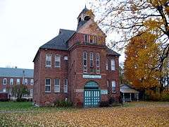
Overackers Corners Schoolhouse |
Upload image |
000000001994-08-24-0000August 24, 1994
(#94000948) |
Vine Valley Rd.
42°44′21″N 77°16′49″W / 42.739167°N 77.280278°W / 42.739167; -77.280278 (Overackers Corners Schoolhouse) |
Middlesex |
|
| 37 |
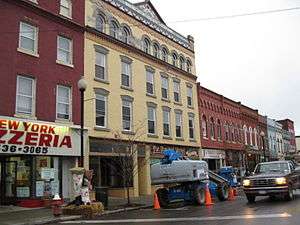
Penn Yan Historic District |
|
000000001985-03-14-0000March 14, 1985
(#85000591) |
Roughly bounded by Water, Seneca, Elm, Wagener, Court, Clinton, North and Main Sts.
42°39′49″N 77°03′08″W / 42.663611°N 77.052222°W / 42.663611; -77.052222 (Penn Yan Historic District) |
Penn Yan |
|
| 38 |
Ezikial Perry House |
Upload image |
000000001994-08-24-0000August 24, 1994
(#94000949) |
287 Sherman Hollow Rd.
42°40′01″N 77°05′57″W / 42.666944°N 77.099167°W / 42.666944; -77.099167 (Ezikial Perry House) |
Jerusalem |
|
| 39 |
Arnold Potter House |
Upload image |
000000001994-08-24-0000August 24, 1994
(#94000950) |
1445 Voak Rd.
42°41′22″N 77°07′44″W / 42.689444°N 77.128889°W / 42.689444; -77.128889 (Arnold Potter House) |
Potter |
|
| 40 |
Miles Raplee House |
Upload image |
000000001994-08-24-0000August 24, 1994
(#94000951) |
Randall Rd.
42°37′03″N 76°55′25″W / 42.6175°N 76.923611°W / 42.6175; -76.923611 (Miles Raplee House) |
Milo |
|
| 41 |
Sampson Theatre |
|
000000002008-11-07-0000November 7, 2008
(#08001035) |
130-136 E. Elm St.
42°39′41″N 77°03′08″W / 42.661511°N 77.052258°W / 42.661511; -77.052258 (Sampson Theatre) |
Penn Yan |
New listing; refnum# 08001035
|
| 42 |
Sill Tenant House |
Upload image |
000000001994-08-24-0000August 24, 1994
(#94000952) |
3232 Co. Rt. 54
42°36′08″N 77°07′18″W / 42.602222°N 77.121667°W / 42.602222; -77.121667 (Sill Tenant House) |
Jerusalem |
|
| 43 |
Dr. Henry Spence Cobblestone Farmhouse and Barn Complex |
Upload image |
000000001992-05-11-0000May 11, 1992
(#92000441) |
Lakemont-Himrod Rd. N of jct. with Shannon Corners Rd.
42°33′21″N 76°56′48″W / 42.555833°N 76.946667°W / 42.555833; -76.946667 (Dr. Henry Spence Cobblestone Farmhouse and Barn Complex) |
Starkey |
|
| 44 |
Spicer-Millard House |
Upload image |
000000001994-08-24-0000August 24, 1994
(#94000953) |
Crystal Springs Rd. (NY 230)
42°30′03″N 77°02′43″W / 42.500833°N 77.045278°W / 42.500833; -77.045278 (Spicer-Millard House) |
Barrington |
|
| 45 |
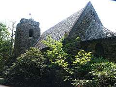
St. Luke's Episcopal Church |
Upload image |
000000001994-08-24-0000August 24, 1994
(#94000954) |
W. Lake Rd. (Co. Rt. 54A)
42°35′48″N 77°09′11″W / 42.596667°N 77.153056°W / 42.596667; -77.153056 (St. Luke's Episcopal Church) |
Jerusalem |
|
| 46 |
Starkey United Methodist Church |
Upload image |
000000001994-08-24-0000August 24, 1994
(#94000955) |
Lakemont-Himrod Rd.
42°32′11″N 76°56′04″W / 42.536389°N 76.934444°W / 42.536389; -76.934444 (Starkey United Methodist Church) |
Starkey |
|
| 47 |
Daniel Supplee Cobblestone Farmhouse |
Upload image |
000000001992-05-11-0000May 11, 1992
(#92000442) |
4420 Dundee-Himrod Rd.
42°33′04″N 76°58′22″W / 42.551111°N 76.972778°W / 42.551111; -76.972778 (Daniel Supplee Cobblestone Farmhouse) |
Starkey |
|
| 48 |
William Swarthout Farm |
Upload image |
000000001994-08-24-0000August 24, 1994
(#94000956) |
Bath Rd.
42°38′03″N 77°03′35″W / 42.634167°N 77.059722°W / 42.634167; -77.059722 (William Swarthout Farm) |
Milo |
|
| 49 |
William Swortz House |
Upload image |
000000001994-08-24-0000August 24, 1994
(#94000957) |
Dundee-Himrod Rd.
42°32′53″N 76°58′24″W / 42.548056°N 76.973333°W / 42.548056; -76.973333 (William Swortz House) |
Starkey |
|
| 50 |
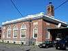
US Post Office-Penn Yan |
|
000000001989-05-11-0000May 11, 1989
(#88002403) |
159 Main St.
42°39′44″N 77°03′16″W / 42.662222°N 77.054444°W / 42.662222; -77.054444 (US Post Office-Penn Yan) |
Penn Yan |
|
| 51 |
Vine Valley Methodist Church |
Upload image |
000000001994-08-24-0000August 24, 1994
(#94000958) |
Robeson Rd.
42°43′26″N 77°19′29″W / 42.723889°N 77.324722°W / 42.723889; -77.324722 (Vine Valley Methodist Church) |
Middlesex |
|
| 52 |
Abraham Wagener House |
|
000000001994-08-24-0000August 24, 1994
(#94000959) |
Skyline Rd.
42°30′36″N 77°08′15″W / 42.51°N 77.1375°W / 42.51; -77.1375 (Abraham Wagener House) |
Jerusalem |
|
| 53 |
Charles Wagener House |
|
000000001994-08-24-0000August 24, 1994
(#94000960) |
351 Elm St.
42°39′39″N 77°03′46″W / 42.660833°N 77.062778°W / 42.660833; -77.062778 (Charles Wagener House) |
Penn Yan |
|
| 54 |
H. Allen Wagener House |
Upload image |
000000001994-08-24-0000August 24, 1994
(#94000961) |
367 W. Lake Rd.
42°37′35″N 77°05′33″W / 42.626389°N 77.0925°W / 42.626389; -77.0925 (H. Allen Wagener House) |
Jerusalem |
|
| 55 |
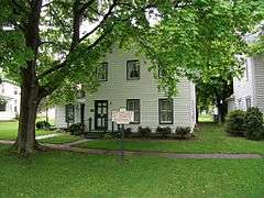
Myron Weaver House |
Upload image |
000000001994-08-24-0000August 24, 1994
(#94000962) |
21 S. Main St.
42°35′39″N 77°09′17″W / 42.594167°N 77.154722°W / 42.594167; -77.154722 (Myron Weaver House) |
Branchport |
|
| 56 |
Solomon Weaver House |
Upload image |
000000001994-08-24-0000August 24, 1994
(#94000963) |
7 S. Main St.
42°35′53″N 77°09′22″W / 42.598056°N 77.156111°W / 42.598056; -77.156111 (Solomon Weaver House) |
Branchport |
|
| 57 |
Whitaker House |
Upload image |
000000001994-08-24-0000August 24, 1994
(#94000964) |
Benton-Torrey Town Line Rd.
42°42′16″N 77°01′03″W / 42.704444°N 77.0175°W / 42.704444; -77.0175 (Whitaker House) |
Benton |
|
| 58 |
Jemima Wilkinson House |
Upload image |
000000001994-08-24-0000August 24, 1994
(#94000965) |
3912 Friend Hill Rd.
42°39′12″N 77°09′54″W / 42.653333°N 77.165°W / 42.653333; -77.165 (Jemima Wilkinson House) |
Jerusalem |
|
| 59 |
Sherman Williams House and Fruit Barn |
Upload image |
000000001994-08-24-0000August 24, 1994
(#94000966) |
Co. Rt. 54A
42°37′22″N 77°05′48″W / 42.622778°N 77.096667°W / 42.622778; -77.096667 (Sherman Williams House and Fruit Barn) |
Jerusalem |
|
| 60 |
Christopher Willis House |
|
000000001994-08-24-0000August 24, 1994
(#94000967) |
57 Seneca St.
42°41′05″N 76°57′03″W / 42.684722°N 76.950833°W / 42.684722; -76.950833 (Christopher Willis House) |
Dresden |
|
| 61 |
Milton Wilson House |
Upload image |
000000001994-08-24-0000August 24, 1994
(#94000968) |
28 Gilbert St.
42°45′37″N 77°13′47″W / 42.760278°N 77.229722°W / 42.760278; -77.229722 (Milton Wilson House) |
Rushville |
|
| 62 |
Abner Woodworth House |
Upload image |
000000001994-08-24-0000August 24, 1994
(#94000969) |
Flat St.
42°41′30″N 77°03′14″W / 42.691667°N 77.053889°W / 42.691667; -77.053889 (Abner Woodworth House) |
Benton |
|
| 63 |
Dr. James Wrightman House |
Upload image |
000000001994-08-24-0000August 24, 1994
(#94000970) |
48 W. Lake Rd.
42°35′28″N 77°09′04″W / 42.591111°N 77.151111°W / 42.591111; -77.151111 (Dr. James Wrightman House) |
Branchport |
|
| 64 |
Yates County Courthouse Park District |
|
000000001979-06-19-0000June 19, 1979
(#79001652) |
Main, Court and Liberty Sts.
42°39′54″N 77°03′28″W / 42.665°N 77.057778°W / 42.665; -77.057778 (Yates County Courthouse Park District) |
Penn Yan |
|
| 65 |
Yatesville Methodist Church |
Upload image |
000000001994-08-25-0000August 25, 1994
(#94000971) |
Yatesville Rd.
42°40′18″N 77°08′16″W / 42.671667°N 77.137778°W / 42.671667; -77.137778 (Yatesville Methodist Church) |
Potter |
|
| 66 |
Young-Leach Cobblestone Farmhouse and Barn Complex |
Upload image |
000000001992-05-11-0000May 11, 1992
(#92000440) |
2601 NY 14
42°38′16″N 76°56′21″W / 42.637778°N 76.939167°W / 42.637778; -76.939167 (Young-Leach Cobblestone Farmhouse and Barn Complex) |
Torrey |
|