| [3] |
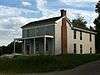
Name on the Register |
Image |
Date listed[4] |
Location |
City or town |
Description |
|---|
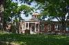
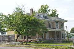
| 1 |
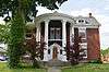
Allen Dale Farm |
Upload image |
000000001983-11-17-0000November 17, 1983
(#83003821) |
Off U.S. Route 60
38°09′08″N 85°14′53″W / 38.152222°N 85.248056°W / 38.152222; -85.248056 (Allen Dale Farm) |
Shelbyville |
|
| 2 |
J. B. Allen House |
Upload image |
000000001988-12-27-0000December 27, 1988
(#88002867) |
Kentucky Route 53, 0.5 miles (0.80 km) north of Chestnut Grove
38°18′40″N 85°15′50″W / 38.311111°N 85.263889°W / 38.311111; -85.263889 (J. B. Allen House) |
Chestnut Grove |
|
| 3 |
William H. Ballard House |
Upload image |
000000001988-12-27-0000December 27, 1988
(#88002936) |
Kentucky Route 53, 0.5 miles (0.80 km) east of McMakin Rd.
38°09′05″N 85°12′40″W / 38.151389°N 85.211111°W / 38.151389; -85.211111 (William H. Ballard House) |
Shelbyville |
|
| 4 |
Bank of Simpsonville |
|
000000001988-12-27-0000December 27, 1988
(#88002878) |
3rd and Railroad Sts.
38°13′29″N 85°21′17″W / 38.224722°N 85.354722°W / 38.224722; -85.354722 (Bank of Simpsonville) |
Simpsonville |
|
| 5 |
Basket Farm |
Upload image |
000000001988-12-27-0000December 27, 1988
(#88002848) |
Kentucky Route 395, 1 mile (1.6 km) south of Kentucky Route 1779
38°12′42″N 85°03′52″W / 38.211667°N 85.064444°W / 38.211667; -85.064444 (Basket Farm) |
Clay Village |
|
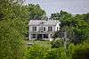
| 6 |
Bayne House |
|
000000001984-09-28-0000September 28, 1984
(#84001989) |
37 Main St.
38°12′39″N 85°12′34″W / 38.210833°N 85.209444°W / 38.210833; -85.209444 (Bayne House) |
Shelbyville |
|
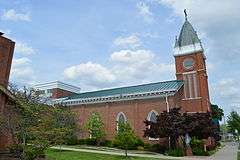
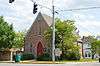
| 7 |
Bethel AME Church |
|
000000001984-09-28-0000September 28, 1984
(#84001990) |
414 Henry Clay St.
38°12′36″N 85°12′54″W / 38.210000°N 85.215000°W / 38.210000; -85.215000 (Bethel AME Church) |
Shelbyville |
|
| 8 |
Bethel Church |
Upload image |
000000001988-12-27-0000December 27, 1988
(#88002907) |
U.S. Route 60, 1 mile (1.6 km) west of Clay Village
38°11′45″N 85°07′37″W / 38.195833°N 85.126944°W / 38.195833; -85.126944 (Bethel Church) |
Clay Village |
|
| 9 |
Bird Octagonal Mule Barn |
Upload image |
000000001988-12-27-0000December 27, 1988
(#88002858) |
Kentucky Route 43, 3 miles (4.8 km) south of Cropper
38°17′16″N 85°07′38″W / 38.287778°N 85.127222°W / 38.287778; -85.127222 (Bird Octagonal Mule Barn) |
Cropper |
|
| 10 |
Bird's Nest |
Upload image |
000000001988-12-27-0000December 27, 1988
(#88002859) |
Kentucky Route 43, 3 miles (4.8 km) south of Cropper
38°16′54″N 85°07′18″W / 38.281667°N 85.121667°W / 38.281667; -85.121667 (Bird's Nest) |
Cropper |
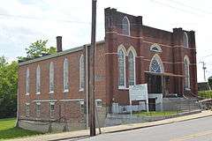
|
| 11 |
Philomen Bird House |
Upload image |
000000001988-12-27-0000December 27, 1988
(#88002917) |
Kentucky Route 1005/Vigo Rd., east of Beards Rd.
38°14′41″N 85°06′52″W / 38.244722°N 85.114444°W / 38.244722; -85.114444 (Philomen Bird House) |
Bagdad |
|
| 12 |
William Blades House |
Upload image |
000000001988-12-27-0000December 27, 1988
(#88002924) |
Kentucky Route 1005, 0.5 miles (0.80 km) west of Kentucky Route 395
38°14′51″N 85°04′35″W / 38.2475°N 85.076389°W / 38.2475; -85.076389 (William Blades House) |
Bagdad |
|
| 13 |
Bland Farm |
Upload image |
000000001988-12-27-0000December 27, 1988
(#88002882) |
Vigo Rd., 1 mile (1.6 km) west of Kentucky Route 1005
38°15′02″N 85°04′50″W / 38.250556°N 85.080556°W / 38.250556; -85.080556 (Bland Farm) |
Bagdad |
|
| 14 |
Blaydes House |
Upload image |
000000001988-12-27-0000December 27, 1988
(#88002852) |
Blaydes Ln., 1 mile (1.6 km) north of Kentucky Route 1779
38°14′24″N 85°03′11″W / 38.24°N 85.053056°W / 38.24; -85.053056 (Blaydes House) |
Bagdad |
|
| 15 |
Samuel Booker House |
Upload image |
000000001988-12-27-0000December 27, 1988
(#88002868) |
Clore-Jackson Rd., 1.5 miles (2.4 km) west of Kentucky Route 55
38°19′35″N 85°13′26″W / 38.326389°N 85.223889°W / 38.326389; -85.223889 (Samuel Booker House) |
Chestnut Grove |
|
| 16 |
Booker-Giltner House |
Upload image |
000000001988-12-27-0000December 27, 1988
(#88002870) |
Kentucky Route 322, 1.5 miles (2.4 km) south of Henry County line
38°20′07″N 85°14′37″W / 38.335278°N 85.243611°W / 38.335278; -85.243611 (Booker-Giltner House) |
Chestnut Grove |
|
| 17 |
Cameron Brown Farm |
Upload image |
000000001988-12-27-0000December 27, 1988
(#88002914) |
Kentucky Route 55 at Clear Creek
38°15′14″N 85°11′51″W / 38.253889°N 85.1975°W / 38.253889; -85.1975 (Cameron Brown Farm) |
Shelbyville |
|
| 18 |
John C. Brown House |
Upload image |
000000001988-12-27-0000December 27, 1988
(#88002856) |
Kentucky Route 43, 0.5 miles (0.80 km) north of Kentucky Route 12
38°16′26″N 85°08′25″W / 38.273889°N 85.140278°W / 38.273889; -85.140278 (John C. Brown House) |
Mulberry |
|
| 19 |
Bryan House |
Upload image |
000000001988-12-27-0000December 27, 1988
(#88002880) |
U.S. Route 60, 0.5 miles (0.80 km) west of Simpsonville
38°13′09″N 85°21′33″W / 38.219167°N 85.359167°W / 38.219167; -85.359167 (Bryan House) |
Simpsonville |
|
| 20 |
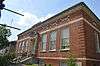
Buck Creek Rosenwald School |
Upload image |
000000002013-03-27-0000March 27, 2013
(#13000113) |
6712 Taylorsville Rd.
38°08′13″N 85°19′16″W / 38.136911°N 85.321071°W / 38.136911; -85.321071 (Buck Creek Rosenwald School) |
Finchville |
|
| 21 |
Building at Jct. of KY 395 and 1779 |
Upload image |
000000001988-12-27-0000December 27, 1988
(#88002885) |
Kentucky Routes 395 and 1779
38°13′32″N 85°03′57″W / 38.225556°N 85.065833°W / 38.225556; -85.065833 (Building at Jct. of KY 395 and 1779) |
Bagdad |
|
| 22 |
Burton House |
Upload image |
000000001988-12-27-0000December 27, 1988
(#88002896) |
Burks Branch Rd., 1 mile (1.6 km) south of Fox Run Rd.
38°15′55″N 85°13′33″W / 38.265278°N 85.225833°W / 38.265278; -85.225833 (Burton House) |
Chestnut Grove |
|
| 23 |
David Burton House |
Upload image |
000000001988-12-27-0000December 27, 1988
(#88002866) |
Burks Branch Rd., 3 miles (4.8 km) north of Shelbyville
38°15′21″N 85°13′42″W / 38.255833°N 85.228333°W / 38.255833; -85.228333 (David Burton House) |
Shelbyville |
|
| 24 |
Caldwell House |
|
000000001988-12-27-0000December 27, 1988
(#88002939) |
U.S. Route 60 at Kentucky Route 53
38°12′36″N 85°12′11″W / 38.210000°N 85.203056°W / 38.210000; -85.203056 (Caldwell House) |
Shelbyville |
|
| 25 |
Calloway House |
Upload image |
000000001988-12-27-0000December 27, 1988
(#88002886) |
Clear Creek Rd., 2 miles (3.2 km) south of the Henry County line
38°19′24″N 85°10′26″W / 38.323333°N 85.173889°W / 38.323333; -85.173889 (Calloway House) |
Eminence |
|
| 26 |
Carnegie Public Library |
|
000000001985-06-12-0000June 12, 1985
(#85001253) |
8th and Washington Sts.
38°12′44″N 85°13′11″W / 38.212222°N 85.219722°W / 38.212222; -85.219722 (Carnegie Public Library) |
Shelbyville |
|
| 27 |
Carpenter House |
Upload image |
000000001988-12-27-0000December 27, 1988
(#88002928) |
Kentucky Route 148, 1 mile (1.6 km) south of Clark Station
38°10′39″N 85°23′59″W / 38.1775°N 85.399722°W / 38.1775; -85.399722 (Carpenter House) |
Clark Station |
|
| 28 |
Carriss's Feed Store |
Upload image |
000000001988-12-27-0000December 27, 1988
(#88002897) |
Kentucky Routes 44 and 55
38°06′35″N 85°11′00″W / 38.109722°N 85.183333°W / 38.109722; -85.183333 (Carriss's Feed Store) |
Southville |
|
| 29 |
Carriss's Store |
Upload image |
000000001988-12-27-0000December 27, 1988
(#88002898) |
Kentucky Routes 53 and 714
38°06′33″N 85°11′00″W / 38.109167°N 85.183333°W / 38.109167; -85.183333 (Carriss's Store) |
Southville |
|
| 30 |
Chiles-Bailey House |
Upload image |
000000001988-12-27-0000December 27, 1988
(#88002923) |
Kentucky Route 395, 0.5 miles (0.80 km) north of Benson Pike
38°13′58″N 85°03′38″W / 38.232778°N 85.060556°W / 38.232778; -85.060556 (Chiles-Bailey House) |
Bagdad |
|
| 31 |
Church of the Annunciation |
|
000000001984-09-28-0000September 28, 1984
(#84002011) |
105 Main St.
38°12′39″N 85°12′38″W / 38.210833°N 85.210556°W / 38.210833; -85.210556 (Church of the Annunciation) |
Shelbyville |
|
| 32 |
Henry Clay School |
Upload image |
000000001988-12-27-0000December 27, 1988
(#88002944) |
U.S. Route 60
38°11′27″N 85°06′00″W / 38.190833°N 85.1°W / 38.190833; -85.1 (Henry Clay School) |
Clay Village |
|
| 33 |
Coca-Cola Plant |
|
000000001988-12-27-0000December 27, 1988
(#88002925) |
U.S. Route 60 at Clear Creek
38°12′36″N 85°12′24″W / 38.210000°N 85.206667°W / 38.210000; -85.206667 (Coca-Cola Plant) |
Shelbyville |
|
| 34 |
Collins House |
Upload image |
000000001988-12-27-0000December 27, 1988
(#88002876) |
Kentucky Route 362, 0.5 miles (0.80 km) west of Webb Rd.
38°17′17″N 85°23′12″W / 38.288056°N 85.386667°W / 38.288056; -85.386667 (Collins House) |
Todds Point |
|
| 35 |
Courtney House |
Upload image |
000000001988-12-27-0000December 27, 1988
(#88002933) |
Southern end of Popes Corner Rd.
38°09′16″N 85°15′56″W / 38.154444°N 85.265556°W / 38.154444; -85.265556 (Courtney House) |
Finchville |
|
| 36 |
John Edward Crockett House |
Upload image |
000000001988-12-27-0000December 27, 1988
(#88002851) |
Logan Rd., 0.5 miles (0.80 km) south of Kentucky Route 12
38°15′15″N 85°07′44″W / 38.254167°N 85.128889°W / 38.254167; -85.128889 (John Edward Crockett House) |
Mulberry |
|
| 37 |
Cross Keys Tavern Kitchen and Quarters |
|
000000001987-01-08-0000January 8, 1987
(#87000205) |
U.S. Route 60
38°11′52″N 85°07′31″W / 38.197778°N 85.125278°W / 38.197778; -85.125278 (Cross Keys Tavern Kitchen and Quarters) |
Shelbyville |
|
| 38 |
John Dale House |
Upload image |
000000001988-12-27-0000December 27, 1988
(#88002877) |
Webb Rd., 1.5 miles (2.4 km) north of U.S. Route 60
38°14′54″N 85°22′45″W / 38.248333°N 85.379167°W / 38.248333; -85.379167 (John Dale House) |
Simpsonville |
|
| 39 |
E. M. Davis Farm |
Upload image |
000000001988-12-27-0000December 27, 1988
(#88002919) |
Kentucky Route 43/Christiansburg Pike, 0.75 miles (1.21 km) east of Kentucky Route 55
38°13′56″N 85°11′08″W / 38.232222°N 85.185556°W / 38.232222; -85.185556 (E. M. Davis Farm) |
Shelbyville |
|
| 40 |
Dependency on Mulberry Creek |
Upload image |
000000001987-01-08-0000January 8, 1987
(#87000167) |
Off Kentucky Route 1871
38°13′56″N 85°10′17″W / 38.232222°N 85.171389°W / 38.232222; -85.171389 (Dependency on Mulberry Creek) |
Shelbyville |
|
| 41 |
Marene Duvall House |
Upload image |
000000001988-12-27-0000December 27, 1988
(#88002905) |
Simpsonville-Buck Creek Rd. at Bullskin Creek
38°10′56″N 85°18′54″W / 38.182222°N 85.315°W / 38.182222; -85.315 (Marene Duvall House) |
Finchville |
|
| 42 |
East Shelbyville District |
|
000000001985-06-12-0000June 12, 1985
(#85001252) |
Roughly E. 3rd St. from Washington to Bradshaw St.
38°12′37″N 85°12′46″W / 38.210278°N 85.212778°W / 38.210278; -85.212778 (East Shelbyville District) |
Shelbyville |
|
| 43 |
Samuel Ellis House |
Upload image |
000000001988-12-27-0000December 27, 1988
(#88002872) |
Kentucky Route 53, 2 miles (3.2 km) west of Kentucky Route 322
38°20′23″N 85°16′30″W / 38.339722°N 85.275°W / 38.339722; -85.275 (Samuel Ellis House) |
Chestnut Grove |
|
| 44 |
Bushrod Figg House |
Upload image |
000000001988-12-27-0000December 27, 1988
(#88002915) |
Zaring Mill Rd., 0.7 miles (1.1 km) northwest of Kentucky Route 148
38°07′53″N 85°15′09″W / 38.131389°N 85.2525°W / 38.131389; -85.2525 (Bushrod Figg House) |
Olive Branch |
|
| 45 |
Froman Fry Farm |
Upload image |
000000001988-12-27-0000December 27, 1988
(#88002952) |
Kentucky Route 714, 1.5 miles (2.4 km) east of Southville
38°07′09″N 85°09′44″W / 38.119167°N 85.162222°W / 38.119167; -85.162222 (Froman Fry Farm) |
Southville |
|
| 46 |
L.C. Fry Farm |
Upload image |
000000001988-12-27-0000December 27, 1988
(#88002884) |
Kentucky Route 53, north of Harrington Mill Rd.
38°14′01″N 85°14′15″W / 38.233611°N 85.2375°W / 38.233611; -85.2375 (L.C. Fry Farm) |
Shelbyville |
|
| 47 |
C.E. Frye Farm |
Upload image |
000000001988-12-27-0000December 27, 1988
(#88002883) |
Kentucky Route 714 and Rockbridge Rd.
38°07′48″N 85°08′29″W / 38.13°N 85.141389°W / 38.13; -85.141389 (C.E. Frye Farm) |
Southville |
|
| 48 |
Fullenwider House |
Upload image |
000000001988-12-27-0000December 27, 1988
(#88002874) |
Anderson Ln., 1 mile (1.6 km) west of Hebron Rd.
38°15′48″N 85°18′18″W / 38.263333°N 85.305°W / 38.263333; -85.305 (Fullenwider House) |
Todds Point |
|
| 49 |
Peter Fullenwielder House |
Upload image |
000000001987-01-08-0000January 8, 1987
(#87000180) |
Off Aikens-Anderson Ln. west of Hebron-Scotts Station Rd.
38°15′58″N 85°18′25″W / 38.266111°N 85.306944°W / 38.266111; -85.306944 (Peter Fullenwielder House) |
Shelbyville |
|
| 50 |
S.D. Glass House |
Upload image |
000000001988-12-27-0000December 27, 1988
(#88002887) |
Kentucky Route 55, 0.5 miles (0.80 km) north of Fox Run Rd.
38°17′07″N 85°11′51″W / 38.285278°N 85.1975°W / 38.285278; -85.1975 (S.D. Glass House) |
Shelbyville |
|
| 51 |
J.W. Goodman House |
Upload image |
000000001988-12-27-0000December 27, 1988
(#88002864) |
Kentucky Route 55, 1 mile (1.6 km) north of Kentucky Route 43
38°14′13″N 85°11′52″W / 38.236944°N 85.197778°W / 38.236944; -85.197778 (J.W. Goodman House) |
Shelbyville |
|
| 52 |
Graham House |
Upload image |
000000001988-12-27-0000December 27, 1988
(#88002849) |
Kentucky Route 1779, 1.5 miles (2.4 km) west of Kentucky Route 395
38°13′06″N 85°05′31″W / 38.218333°N 85.091944°W / 38.218333; -85.091944 (Graham House) |
Clay Village |
|
| 53 |
Grasslands |
Upload image |
000000001977-08-12-0000August 12, 1977
(#77000645) |
4 miles (6.4 km) west of Finchville
38°10′54″N 85°22′43″W / 38.181667°N 85.378611°W / 38.181667; -85.378611 (Grasslands) |
Finchville |
|
| 54 |
Gray House |
Upload image |
000000001988-12-27-0000December 27, 1988
(#88002913) |
Zaring Mill Rd., 0.3 miles (0.48 km) south of Locust Grove Rd.
38°08′06″N 85°14′59″W / 38.135°N 85.249722°W / 38.135; -85.249722 (Gray House) |
Shelbyville |
|
| 55 |
Grove Hill Cemetery Chapel |
|
000000001988-12-27-0000December 27, 1988
(#88002922) |
South of Shelbyville at Clear Creek
38°12′23″N 85°12′35″W / 38.206389°N 85.209722°W / 38.206389; -85.209722 (Grove Hill Cemetery Chapel) |
Shelbyville |
|
| 56 |
John G. and William Hansbrough House |
Upload image |
000000001988-12-27-0000December 27, 1988
(#88002865) |
Burks Branch Rd., 1.5 miles (2.4 km) north of Shelbyville
38°14′06″N 85°13′25″W / 38.235°N 85.223611°W / 38.235; -85.223611 (John G. and William Hansbrough House) |
Shelbyville |
|
| 57 |
Harbison House |
Upload image |
000000001988-12-27-0000December 27, 1988
(#88002875) |
Harrington Mill Pike, 1.5 miles (2.4 km) west of Kentucky Route 53
38°13′58″N 85°16′04″W / 38.232778°N 85.267778°W / 38.232778; -85.267778 (Harbison House) |
Scotts Station |
|
| 58 |
Harbison House |
Upload image |
000000001988-12-27-0000December 27, 1988
(#88002931) |
Zaring Mill Rd., 0.25 miles (0.40 km) south of Interstate 64
38°10′50″N 85°14′26″W / 38.180556°N 85.240556°W / 38.180556; -85.240556 (Harbison House) |
Shelbyville |
|
| 59 |
Hedden House |
Upload image |
000000001988-12-27-0000December 27, 1988
(#88002846) |
Kentucky Route 637 and Ditto Rd.
38°06′21″N 85°02′48″W / 38.105833°N 85.046667°W / 38.105833; -85.046667 (Hedden House) |
Harrisonville |
|
| 60 |
Helmwood Hall |
Upload image |
000000001986-03-20-0000March 20, 1986
(#86000463) |
Kentucky Route 55 at Moody Pike
38°18′02″N 85°11′48″W / 38.300556°N 85.196667°W / 38.300556; -85.196667 (Helmwood Hall) |
Shelbyville |
|
| 61 |
Hinton-Scearce House |
Upload image |
000000002009-07-24-0000July 24, 2009
(#09000571) |
212 Adams Pike
38°17′53″N 85°14′32″W / 38.298061°N 85.242114°W / 38.298061; -85.242114 (Hinton-Scearce House) |
Shelbyville |
|
| 62 |
Hornsby Bridge |
Upload image |
000000001988-12-27-0000December 27, 1988
(#88002906) |
Clore-Jackson Rd. over Fox Run, 0.5 miles (0.80 km) west of Kentucky Route 55
38°19′04″N 85°12′16″W / 38.317778°N 85.204444°W / 38.317778; -85.204444 (Hornsby Bridge) |
Eminence |
|
| 63 |
John A. Hornsby House |
Upload image |
000000001988-12-27-0000December 27, 1988
(#88002869) |
Clore-Jackson Rd., 0.5 miles (0.80 km) west of Kentucky Route 55
38°19′16″N 85°12′20″W / 38.321111°N 85.205556°W / 38.321111; -85.205556 (John A. Hornsby House) |
Eminence |
|
| 64 |
M.W. Huss House |
Upload image |
000000001988-12-27-0000December 27, 1988
(#88002946) |
U.S. Route 60, 0.5 miles (0.80 km) east of Clay Village
38°11′26″N 85°05′39″W / 38.190556°N 85.094167°W / 38.190556; -85.094167 (M.W. Huss House) |
Clay Village |
|
| 65 |
Eli Jackson House |
Upload image |
000000001988-12-27-0000December 27, 1988
(#88002891) |
Kentucky Route 55 near the junction with Clore-Jackson Rd.
38°18′42″N 85°11′52″W / 38.311667°N 85.197778°W / 38.311667; -85.197778 (Eli Jackson House) |
Eminence |
|
| 66 |
Johnston House |
Upload image |
000000001988-12-27-0000December 27, 1988
(#88002890) |
Kentucky Routes 714 and 1790
38°10′49″N 85°08′20″W / 38.180278°N 85.138889°W / 38.180278; -85.138889 (Johnston House) |
Clay Village |
|
| 67 |
M.J. King House |
Upload image |
000000001988-12-27-0000December 27, 1988
(#88002916) |
Bellview-Clear Creek Rd., 0.3 miles (0.48 km) west of Bellview Rd.
38°16′19″N 85°10′53″W / 38.271944°N 85.181389°W / 38.271944; -85.181389 (M.J. King House) |
Shelbyville |
|
| 68 |
Knight-Stout House |
Upload image |
000000001975-08-19-0000August 19, 1975
(#75000829) |
1 mile (1.6 km) north of Finchville on Kentucky Route 55
38°09′44″N 85°18′21″W / 38.162222°N 85.305833°W / 38.162222; -85.305833 (Knight-Stout House) |
Finchville |
|
| 69 |
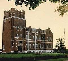
Lincoln Institute Complex |
|
000000001988-12-27-0000December 27, 1988
(#88002926) |
U.S. Route 60 west of Simpsonville
38°13′02″N 85°22′32″W / 38.217222°N 85.375556°W / 38.217222; -85.375556 (Lincoln Institute Complex) |
Simpsonville |
|
| 70 |
Logan House |
Upload image |
000000001988-12-27-0000December 27, 1988
(#88002929) |
Brunerstown Rd. at Bullskin Creek
38°11′31″N 85°18′01″W / 38.191944°N 85.300278°W / 38.191944; -85.300278 (Logan House) |
Finchville |
|
| 71 |
D. T. Long House |
Upload image |
000000001988-12-27-0000December 27, 1988
(#88002902) |
U.S. Route 60 and Joyes Station Rd.
38°13′02″N 85°17′24″W / 38.217222°N 85.29°W / 38.217222; -85.29 (D. T. Long House) |
Scotts Station |
|
| 72 |
Martin House |
Upload image |
000000001988-12-27-0000December 27, 1988
(#88002937) |
Kentucky Route 53, 1 mile (1.6 km) south of Rockbridge Rd.
38°09′47″N 85°12′49″W / 38.163056°N 85.213611°W / 38.163056; -85.213611 (Martin House) |
Shelbyville |
|
| 73 |
McMicken House |
Upload image |
000000001988-12-27-0000December 27, 1988
(#88002871) |
Kentucky Route 53, 2.5 miles (4.0 km) west of Kentucky Route 322
38°20′10″N 85°17′29″W / 38.336111°N 85.291389°W / 38.336111; -85.291389 (McMicken House) |
Chestnut Grove |
|
| 74 |
Henri Middleton House |
Upload image |
000000001988-12-27-0000December 27, 1988
(#88002847) |
Old U.S. Route 60, 0.75 miles (1.21 km) east of Peytona
38°07′04″N 85°03′30″W / 38.117778°N 85.058333°W / 38.117778; -85.058333 (Henri Middleton House) |
Peytona |
|
| 75 |
Money Farm |
Upload image |
000000001988-12-27-0000December 27, 1988
(#88002910) |
Finchville Rd., 0.6 miles (0.97 km) south of Brunerstown Rd.
38°10′53″N 85°19′20″W / 38.181389°N 85.322222°W / 38.181389; -85.322222 (Money Farm) |
Finchville |
|
| 76 |
Montgomery House |
Upload image |
000000001988-12-27-0000December 27, 1988
(#88002948) |
Buzzard Roost Rd., 1.5 miles (2.4 km) south of U.S. Route 60
38°10′07″N 85°05′31″W / 38.168611°N 85.091944°W / 38.168611; -85.091944 (Montgomery House) |
Clay Village |
|
| 77 |
Dr. William Morris Office and House |
Upload image |
000000001988-12-27-0000December 27, 1988
(#88002909) |
Kentucky Route 53
38°06′39″N 85°11′03″W / 38.110833°N 85.184167°W / 38.110833; -85.184167 (Dr. William Morris Office and House) |
Southville |
|
| 78 |
Moxley Farm |
Upload image |
000000001988-12-27-0000December 27, 1988
(#88002932) |
Zaring Mill Rd. south of Interstate 64
38°10′53″N 85°13′53″W / 38.181389°N 85.231389°W / 38.181389; -85.231389 (Moxley Farm) |
Shelbyville |
|
| 79 |
Muir House |
Upload image |
000000001988-12-27-0000December 27, 1988
(#88002899) |
Montana St. at Clear Creek
38°11′56″N 85°14′09″W / 38.198889°N 85.235833°W / 38.198889; -85.235833 (Muir House) |
Shelbyville |
|
| 80 |
Dr. Nash House |
|
000000001988-12-27-0000December 27, 1988
(#88002903) |
U.S. Route 60
38°11′33″N 85°06′37″W / 38.1925°N 85.110278°W / 38.1925; -85.110278 (Dr. Nash House) |
Clay Village |
|
| 81 |
Neal-Hamblen House |
Upload image |
000000001988-12-27-0000December 27, 1988
(#88002873) |
Hinkle Ln., 2 miles (3.2 km) west of Kentucky Route 53
38°19′13″N 85°17′31″W / 38.320278°N 85.291944°W / 38.320278; -85.291944 (Neal-Hamblen House) |
Chestnut Grove |
|
| 82 |
Newton House |
Upload image |
000000001988-12-27-0000December 27, 1988
(#88002943) |
U.S. Route 60
38°11′31″N 85°06′19″W / 38.191944°N 85.105278°W / 38.191944; -85.105278 (Newton House) |
Clay Village |
|
| 83 |
Old Stone Inn |
|
000000001976-10-08-0000October 8, 1976
(#76000944) |
East of Simpsonville on U.S. Route 60
38°13′21″N 85°20′52″W / 38.2225°N 85.347778°W / 38.2225; -85.347778 (Old Stone Inn) |
Simpsonville |
|
| 84 |
Olive Branch Methodist Episcopal Church |
Upload image |
000000001988-12-27-0000December 27, 1988
(#88002895) |
Zaring Mill Rd. and Kentucky Route 148
38°07′38″N 85°15′45″W / 38.127222°N 85.2625°W / 38.127222; -85.2625 (Olive Branch Methodist Episcopal Church) |
Finchville |
|
| 85 |
Brackett Owen House |
Upload image |
000000001988-12-27-0000December 27, 1988
(#88002940) |
Hooper Station Rd., 0.25 miles (0.40 km) east of Kentucky Route 53
38°12′12″N 85°12′02″W / 38.203333°N 85.200556°W / 38.203333; -85.200556 (Brackett Owen House) |
Shelbyville |
|
| 86 |
Payne House |
Upload image |
000000001988-12-27-0000December 27, 1988
(#88002954) |
Kentucky Routes 44/53, 1.5 miles (2.4 km) north of Mount Eden
38°04′41″N 85°10′18″W / 38.078056°N 85.171667°W / 38.078056; -85.171667 (Payne House) |
Mount Eden |
|
| 87 |
Pemberton Farm |
Upload image |
000000001988-12-27-0000December 27, 1988
(#88002908) |
Finchville-Clark Station Rd., 0.5 miles (0.80 km) east of Kentucky Route 148
38°09′50″N 85°22′51″W / 38.163889°N 85.380833°W / 38.163889; -85.380833 (Pemberton Farm) |
Clark |
|
| 88 |
James A. Pickett House |
Upload image |
000000001988-12-27-0000December 27, 1988
(#88002930) |
Kentucky Route 55, 0.75 miles (1.21 km) south of Kentucky Route 148
38°08′12″N 85°19′15″W / 38.136667°N 85.320833°W / 38.136667; -85.320833 (James A. Pickett House) |
Finchville |
|
| 89 |
Pugh House |
Upload image |
000000001988-12-27-0000December 27, 1988
(#88002935) |
Kentucky Route 44, 1 mile (1.6 km) west of Kentucky Route 53
38°06′41″N 85°12′13″W / 38.111389°N 85.203611°W / 38.111389; -85.203611 (Pugh House) |
Southville |
|
| 90 |
Radcliffe-Duvall Farm |
Upload image |
000000001988-12-27-0000December 27, 1988
(#88002920) |
Finchville-Buck Creek Rd., 0.5 miles (0.80 km) south of Brunnerstown Rd.
38°10′58″N 85°19′59″W / 38.182778°N 85.333056°W / 38.182778; -85.333056 (Radcliffe-Duvall Farm) |
Finchville |
|
| 91 |
Ramsey House |
Upload image |
000000001988-12-27-0000December 27, 1988
(#88002934) |
Kentucky Route 148, 1.5 miles (2.4 km) west of Kentucky Route 44
38°06′46″N 85°14′23″W / 38.112778°N 85.239722°W / 38.112778; -85.239722 (Ramsey House) |
Southville |
|
| 92 |
Redmon House |
Upload image |
000000001988-12-27-0000December 27, 1988
(#88002853) |
Kentucky Route 395, 2 miles (3.2 km) north of Bagdad
38°17′14″N 85°03′36″W / 38.287222°N 85.06°W / 38.287222; -85.06 (Redmon House) |
Bagdad |
|
| 93 |
Rice House |
Upload image |
000000001988-12-27-0000December 27, 1988
(#88002945) |
U.S. Route 60, 0.5 miles (0.80 km) north of Clay Village
38°11′58″N 85°06′19″W / 38.199444°N 85.105278°W / 38.199444; -85.105278 (Rice House) |
Clay Village |
|
| 94 |
Robertson House |
Upload image |
000000001988-12-27-0000December 27, 1988
(#88002949) |
Buzzard Roost Rd., 1.5 miles (2.4 km) east of Hemp Ridge
38°09′27″N 85°06′03″W / 38.1575°N 85.100833°W / 38.1575; -85.100833 (Robertson House) |
Hemp Ridge |
|
| 95 |
Rodgers House |
Upload image |
000000001988-12-27-0000December 27, 1988
(#88002918) |
Zaring Mill Rd., 1.5 miles (2.4 km) south of Popes Corner Rd.
38°09′06″N 85°14′41″W / 38.151667°N 85.244722°W / 38.151667; -85.244722 (Rodgers House) |
Shelbyville |
|
| 96 |
Royalty-Smith Farm |
Upload image |
000000001988-12-27-0000December 27, 1988
(#88002901) |
Burks Branch Rd. north of Clear Creek
38°14′00″N 85°13′35″W / 38.233333°N 85.226389°W / 38.233333; -85.226389 (Royalty-Smith Farm) |
Shelbyville |
|
| 97 |
Saffell Funeral Home |
|
000000001984-09-28-0000September 28, 1984
(#84002012) |
4th and Clay Sts.
38°12′35″N 85°12′50″W / 38.209722°N 85.213889°W / 38.209722; -85.213889 (Saffell Funeral Home) |
Shelbyville |
|
| 98 |
St. John United Methodist Church |
|
000000001984-09-28-0000September 28, 1984
(#84002016) |
College St.
38°12′48″N 85°13′27″W / 38.213333°N 85.224167°W / 38.213333; -85.224167 (St. John United Methodist Church) |
Shelbyville |
|
| 99 |
Salem Baptist Church |
Upload image |
000000001988-12-27-0000December 27, 1988
(#88002953) |
Kentucky Routes 44/53, 0.5 miles (0.80 km) south of Southville
38°06′19″N 85°10′44″W / 38.105278°N 85.178889°W / 38.105278; -85.178889 (Salem Baptist Church) |
Southville |
|
| 100 |
Science Hill School |
|
000000001975-09-18-0000September 18, 1975
(#75000831) |
Washington St.
38°12′44″N 85°13′01″W / 38.212222°N 85.216944°W / 38.212222; -85.216944 (Science Hill School) |
Shelbyville |
|
| 101 |
Seventh Street Historic District |
|
000000001985-06-12-0000June 12, 1985
(#85001254) |
Main and 7th Sts.
38°12′41″N 85°13′06″W / 38.211389°N 85.218333°W / 38.211389; -85.218333 (Seventh Street Historic District) |
Shelbyville |
|
| 102 |
Shady Rest |
Upload image |
000000001988-12-27-0000December 27, 1988
(#88002947) |
U.S. Route 60, 0.5 miles (0.80 km) east of Clay Village
38°11′25″N 85°05′33″W / 38.190278°N 85.0925°W / 38.190278; -85.0925 (Shady Rest) |
Clay Village |
|
| 103 |
Shelby Academy |
Upload image |
000000001975-09-18-0000September 18, 1975
(#75000830) |
Kentucky Routes 55 and 148
38°08′48″N 85°19′01″W / 38.146667°N 85.316944°W / 38.146667; -85.316944 (Shelby Academy) |
Finchville |
|
| 104 |
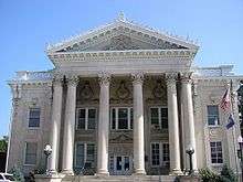
Shelby County Courthouse and Main Street Commercial District |
|
000000001978-03-21-0000March 21, 1978
(#78001399) |
Roughly bounded by Washington, Clay, 4th, and 6th Sts.
38°12′39″N 85°13′01″W / 38.210833°N 85.216944°W / 38.210833; -85.216944 (Shelby County Courthouse and Main Street Commercial District) |
Shelbyville |
|
| 105 |
Shelbyville L&N Railroad Depot |
|
000000001975-06-20-0000June 20, 1975
(#75000832) |
220 N. 7th St.
38°12′47″N 85°13′11″W / 38.213056°N 85.219722°W / 38.213056; -85.219722 (Shelbyville L&N Railroad Depot) |
Shelbyville |
|
| 106 |
Shropshire Farm |
Upload image |
000000001988-12-27-0000December 27, 1988
(#88002911) |
Kentucky Route 714/Hemp Ridge Rd., 1 mile (1.6 km) south of Interstate 64
38°09′12″N 85°07′55″W / 38.153333°N 85.131944°W / 38.153333; -85.131944 (Shropshire Farm) |
Hemp Ridge |
|
| 107 |
Simpsonville Christian Church |
|
000000001988-12-27-0000December 27, 1988
(#88002881) |
U.S. Route 60
38°13′19″N 85°21′13″W / 38.221944°N 85.353611°W / 38.221944; -85.353611 (Simpsonville Christian Church) |
Simpsonville |
|
| 108 |
Simpsonville Methodist Church |
Upload image |
000000001988-12-27-0000December 27, 1988
(#88002879) |
1st St.
38°13′30″N 85°21′17″W / 38.225°N 85.354722°W / 38.225; -85.354722 (Simpsonville Methodist Church) |
Simpsonville |
|
| 109 |
William Sleadd Farm |
Upload image |
000000001988-12-27-0000December 27, 1988
(#88002941) |
Kentucky Route 1790, 0.5 miles (0.80 km) east of Hooper
38°10′42″N 85°08′58″W / 38.178333°N 85.149444°W / 38.178333; -85.149444 (William Sleadd Farm) |
Hooper |
|
| 110 |
Snook House |
Upload image |
000000001988-12-27-0000December 27, 1988
(#88002855) |
Kentucky Routes 12 and 43
38°15′54″N 85°08′32″W / 38.265°N 85.142222°W / 38.265; -85.142222 (Snook House) |
Mulberry |
|
| 111 |
Van B. Snook House |
Upload image |
000000001988-12-27-0000December 27, 1988
(#88002863) |
Mulberry-Eminence Pike, 1 mile (1.6 km) north of Stoney Point Rd.
38°19′15″N 85°09′07″W / 38.320833°N 85.151944°W / 38.320833; -85.151944 (Van B. Snook House) |
Cropper |
|
| 112 |
Stapleton Farm |
Upload image |
000000001988-12-27-0000December 27, 1988
(#88002912) |
Kentucky Route 1005/Vigo Rd., 0.5 miles (0.80 km) east of Logan Rd.
38°14′45″N 85°06′46″W / 38.245833°N 85.112778°W / 38.245833; -85.112778 (Stapleton Farm) |
Bagdad |
|
| 113 |
G.W. Stewart House |
Upload image |
000000001988-12-27-0000December 27, 1988
(#88002888) |
Kentucky Route 55
38°15′42″N 85°12′29″W / 38.261667°N 85.208056°W / 38.261667; -85.208056 (G.W. Stewart House) |
Shelbyville |
|
| 114 |
Stone House on Clear Creek |
Upload image |
000000001987-01-08-0000January 8, 1987
(#87000141) |
Off Kentucky Route 55 west of Bellview Rd.
38°15′25″N 85°11′12″W / 38.256944°N 85.186667°W / 38.256944; -85.186667 (Stone House on Clear Creek) |
Shelbyville |
|
| 115 |
Sturgeon-Gregg House |
Upload image |
000000001984-11-29-0000November 29, 1984
(#84000418) |
U.S. Route 60
38°14′56″N 85°24′11″W / 38.248889°N 85.403056°W / 38.248889; -85.403056 (Sturgeon-Gregg House) |
Simpsonville |
|
| 116 |
Swindler House |
Upload image |
000000001988-12-27-0000December 27, 1988
(#88002862) |
Mulberry-Eminence Pike, 0.5 miles (0.80 km) north of Stoney Point Rd.
38°18′42″N 85°09′09″W / 38.311667°N 85.1525°W / 38.311667; -85.1525 (Swindler House) |
Cropper |
|
| 117 |
Tevis Cottage |
|
000000001984-09-28-0000September 28, 1984
(#84002018) |
607 Washington St.
38°12′43″N 85°13′03″W / 38.212083°N 85.217500°W / 38.212083; -85.217500 (Tevis Cottage) |
Shelbyville |
|
| 118 |
Thomas House |
Upload image |
000000001988-12-27-0000December 27, 1988
(#88002857) |
Kentucky Route 43, 0.25 miles (0.40 km) east of Mulberry-Eminence Pike
38°17′10″N 85°08′23″W / 38.286111°N 85.139722°W / 38.286111; -85.139722 (Thomas House) |
Mulberry |
|
| 119 |
William J. Thomas House |
Upload image |
000000001988-12-27-0000December 27, 1988
(#88002860) |
Off Kentucky Route 12, near the junction with Kentucky Route 43
38°16′22″N 85°09′06″W / 38.272778°N 85.151667°W / 38.272778; -85.151667 (William J. Thomas House) |
Mulberry |
|
| 120 |
Thomas Threlkeld House |
|
000000001984-05-14-0000May 14, 1984
(#84002021) |
Benson Pike
38°12′38″N 85°07′58″W / 38.210556°N 85.132778°W / 38.210556; -85.132778 (Thomas Threlkeld House) |
Shelbyville |
|
| 121 |
Tindall House |
Upload image |
000000001988-12-27-0000December 27, 1988
(#88002904) |
U.S. Route 60
38°11′32″N 85°06′32″W / 38.192222°N 85.108889°W / 38.192222; -85.108889 (Tindall House) |
Clay Village |
|
| 122 |
Charles and Letitia Shelby Todd House |
Upload image |
000000001975-06-05-0000June 5, 1975
(#75000833) |
5 miles (8.0 km) north of Shelbyville on Kentucky Route 55
38°17′04″N 85°13′03″W / 38.284444°N 85.2175°W / 38.284444; -85.2175 (Charles and Letitia Shelby Todd House) |
Shelbyville |
|
| 123 |
Undulata |
Upload image |
000000001980-06-22-0000June 22, 1980
(#80004519) |
South of Shelbyville on Old Zaring Mill Rd.
38°11′20″N 85°14′10″W / 38.188889°N 85.236111°W / 38.188889; -85.236111 (Undulata) |
Shelbyville |
|
| 124 |
Vanatta House |
Upload image |
000000001988-12-27-0000December 27, 1988
(#88002942) |
U.S. Route 60
38°11′32″N 85°06′28″W / 38.192222°N 85.107778°W / 38.192222; -85.107778 (Vanatta House) |
Clay Village |
|
| 125 |
Venable-Chase House |
Upload image |
000000001988-12-27-0000December 27, 1988
(#88002861) |
Kentucky Route 43, 2.5 miles (4.0 km) northeast of Shelbyville
38°14′08″N 85°10′52″W / 38.235556°N 85.181111°W / 38.235556; -85.181111 (Venable-Chase House) |
Shelbyville |
|
| 126 |
Waddy Bank Building |
Upload image |
000000001978-02-14-0000February 14, 1978
(#78001400) |
Kentucky Route 395
38°08′14″N 85°04′27″W / 38.137222°N 85.074167°W / 38.137222; -85.074167 (Waddy Bank Building) |
Waddy |
|
| 127 |
Waddy Historic District |
Upload image |
000000001988-12-27-0000December 27, 1988
(#88002921) |
Roughly Kentucky Route 395/Main St. south of the Southern Railroad tracks
38°08′13″N 85°04′29″W / 38.136944°N 85.074722°W / 38.136944; -85.074722 (Waddy Historic District) |
Waddy |
|
| 128 |
Charles Ware House |
Upload image |
000000001988-12-27-0000December 27, 1988
(#88002845) |
Pea Ridge Rd., 0.5 miles (0.80 km) west of Kentucky Route 395
38°05′30″N 85°05′46″W / 38.091667°N 85.096111°W / 38.091667; -85.096111 (Charles Ware House) |
Harrisonville |
|
| 129 |
Shelby D. Ware House |
Upload image |
000000001988-12-27-0000December 27, 1988
(#88002950) |
Kentucky Route 714, 0.5 miles (0.80 km) south of Hemp Ridge
38°08′27″N 85°06′56″W / 38.140833°N 85.115556°W / 38.140833; -85.115556 (Shelby D. Ware House) |
Hemp Ridge |
|
| 130 |
Benjamin Washburn House |
Upload image |
000000001977-08-12-0000August 12, 1977
(#77000646) |
Bellevue Pike, 8 miles (13 km) north of Shelbyville
38°18′10″N 85°09′31″W / 38.302778°N 85.158611°W / 38.302778; -85.158611 (Benjamin Washburn House) |
Shelbyville |
|
| 131 |
Thomas Weakley House |
Upload image |
000000001988-12-27-0000December 27, 1988
(#88002850) |
Kentucky Route 1779 and Beard Rd.
38°13′34″N 85°06′55″W / 38.226111°N 85.115278°W / 38.226111; -85.115278 (Thomas Weakley House) |
Clay Village |
|
| 132 |
Weissinger Mule Barn |
Upload image |
000000001988-12-27-0000December 27, 1988
(#88002938) |
Kentucky Route 53, 0.25 miles (0.40 km) south of Interstate 64
38°10′47″N 85°13′12″W / 38.179722°N 85.22°W / 38.179722; -85.22 (Weissinger Mule Barn) |
Shelbyville |
|
| 133 |
West Shelbyville District |
|
000000001985-06-12-0000June 12, 1985
(#85001273) |
Roughly Main from Adair to 8th, Magnolia to Linden, 7th, 8th, 9th, 10th, and Bland Sts.
38°12′38″N 85°13′28″W / 38.210556°N 85.224444°W / 38.210556; -85.224444 (West Shelbyville District) |
Shelbyville |
|
| 134 |
White House |
Upload image |
000000001988-12-27-0000December 27, 1988
(#88002854) |
Cropper Rd., 0.75 miles (1.21 km) south of Christianburg
38°16′09″N 85°06′22″W / 38.269167°N 85.106111°W / 38.269167; -85.106111 (White House) |
Christianburg |
|
| 135 |
Wickland |
|
000000001984-09-28-0000September 28, 1984
(#84002023) |
169 Kentucky St.
38°12′31″N 85°13′33″W / 38.208611°N 85.225833°W / 38.208611; -85.225833 (Wickland) |
Shelbyville |
|
| 136 |
Wise House |
Upload image |
000000001988-12-27-0000December 27, 1988
(#88002955) |
Kentucky Routes 44/53, 0.5 miles (0.80 km) north of Mount Eden
38°03′55″N 85°09′30″W / 38.065278°N 85.158333°W / 38.065278; -85.158333 (Wise House) |
Mount Eden |
|
| 137 |
Wright House |
Upload image |
000000001988-12-27-0000December 27, 1988
(#88002927) |
Kentucky Route 1848, 1.5 miles (2.4 km) south of Simpsonville
38°11′55″N 85°20′56″W / 38.198611°N 85.348889°W / 38.198611; -85.348889 (Wright House) |
Simpsonville |
|
| 138 |
Whitney M. Young, Jr. Birthplace |
|
000000001972-10-18-0000October 18, 1972
(#72000543) |
Southwest of Simpsonville off U.S. Route 60
38°13′22″N 85°22′20″W / 38.222667°N 85.372222°W / 38.222667; -85.372222 (Whitney M. Young, Jr. Birthplace) |
Simpsonville |
|