| [3] |
Name on the Register |
Image |
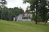
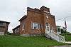
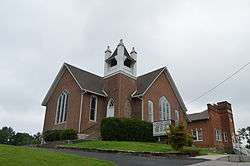
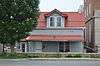
Date listed[4] |
Location |
City or town |
Description |
|---|
| 1 |
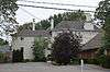
Battle of Dutton's Hill Monument |
|
000000001997-07-17-0000July 17, 1997
(#97000670) |
Old Crab Orchard Rd., 1 mile north of the junction of Kentucky Routes 39 and 80
37°07′03″N 84°36′14″W / 37.1175°N 84.603889°W / 37.1175; -84.603889 (Battle of Dutton's Hill Monument) |
Somerset |
|
| 2 |
Battle of Mill Springs Historic Areas |
|
000000001993-02-18-0000February 18, 1993
(#93000001) |
Three discontiguous areas: one south of Nancy, one in Mill Springs, and one to the north across the Cumberland River
37°00′19″N 84°45′28″W / 37.005278°N 84.757778°W / 37.005278; -84.757778 (Battle of Mill Springs Historic Areas) |
Nancy |
|
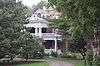
| 3 |
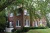
Beatty-Newell House |
|
000000001985-08-16-0000August 16, 1985
(#85001834) |
Off Kentucky Route 90
36°59′09″N 84°37′04″W / 36.985833°N 84.617778°W / 36.985833; -84.617778 (Beatty-Newell House) |
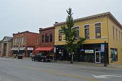
Bronston |
|
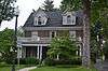
| 4 |
Boland House |
|
000000001984-08-14-0000August 14, 1984
(#84001939) |
Lakeshore Dr.
36°59′24″N 84°36′19″W / 36.990000°N 84.605278°W / 36.990000; -84.605278 (Boland House) |
Burnside |
|
| 5 |
Buck-Mercer House |
Upload image |
000000001984-08-14-0000August 14, 1984
(#84001941) |
Waynesburg Rd.
37°14′02″N 84°35′04″W / 37.233889°N 84.584444°W / 37.233889; -84.584444 (Buck-Mercer House) |
Somerset |
|
| 6 |
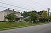
Burnside Historic District |
|
000000001984-08-14-0000August 14, 1984
(#84001944) |
Lakeshore Dr. and French Ave.
36°59′12″N 84°36′11″W / 36.986667°N 84.603056°W / 36.986667; -84.603056 (Burnside Historic District) |
Burnside |
|
| 7 |
Burnside Lodge |
|
000000001984-08-14-0000August 14, 1984
(#84001946) |
Off U.S. Route 27
36°59′13″N 84°36′03″W / 36.986944°N 84.600833°W / 36.986944; -84.600833 (Burnside Lodge) |
Burnside |
|
| 8 |
Burnside Methodist Church |
|
000000001985-08-16-0000August 16, 1985
(#85001836) |
Off U.S. Route 27
36°59′13″N 84°36′03″W / 36.986806°N 84.600972°W / 36.986806; -84.600972 (Burnside Methodist Church) |
Burnside |
|
| 9 |
Confederate Mass Grave Monument in Nancy |
|
000000001997-07-17-0000July 17, 1997
(#97000671) |
Zollicoffer Park Cemetery, 0.3 miles south of the junction of Kentucky Routes 235 and 761
37°03′20″N 84°44′22″W / 37.055556°N 84.739444°W / 37.055556; -84.739444 (Confederate Mass Grave Monument in Nancy) |
Nancy |
|
| 10 |
Crawford House |
|
000000001984-08-14-0000August 14, 1984
(#84001952) |
121 Maple St.
37°05′40″N 84°36′15″W / 37.094444°N 84.604167°W / 37.094444; -84.604167 (Crawford House) |
Somerset |
|
| 11 |
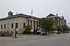
A. Jackson Crawford Building |
|
000000001980-08-18-0000August 18, 1980
(#80001665) |
207 S. Main St.
37°05′25″N 84°36′15″W / 37.090278°N 84.604167°W / 37.090278; -84.604167 (A. Jackson Crawford Building) |
Somerset |
|
| 12 |
Dabney Post Office |
Upload image |
000000001984-08-14-0000August 14, 1984
(#84001954) |
Kentucky Route 39
37°10′57″N 84°33′00″W / 37.1825°N 84.55°W / 37.1825; -84.55 (Dabney Post Office) |
Dabney |
|
| 13 |
Evans House |
Upload image |
000000001985-08-16-0000August 16, 1985
(#85001837) |
Kentucky Route 461
37°12′10″N 84°27′40″W / 37.202778°N 84.461111°W / 37.202778; -84.461111 (Evans House) |
Shopville |
|
| 14 |
William Fox House |
|
000000001978-07-31-0000July 31, 1978
(#78001391) |
206 W. Columbia St.
37°05′34″N 84°36′26″W / 37.092778°N 84.607361°W / 37.092778; -84.607361 (William Fox House) |
Somerset |
|
| 15 |
Gover-Hardin House |
|
000000002007-07-11-0000July 11, 2007
(#07000674) |
307 W. Mt. Vernon St.
37°05′29″N 84°36′28″W / 37.091389°N 84.607778°W / 37.091389; -84.607778 (Gover-Hardin House) |
Somerset |
|
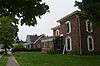
| 16 |
Harvey's Hill Historic District |
|
000000001984-08-14-0000August 14, 1984
(#84001958) |
401-527 N. Main St., and 402-526 N. Main St.
37°05′49″N 84°36′24″W / 37.096944°N 84.606667°W / 37.096944; -84.606667 (Harvey's Hill Historic District) |
Somerset |
|
| 17 |
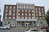
Hotel Beecher |
|
000000001984-08-14-0000August 14, 1984
(#84001960) |
203 S. Main St.
37°05′26″N 84°36′16″W / 37.090556°N 84.604444°W / 37.090556; -84.604444 (Hotel Beecher) |
Somerset |
|
| 18 |
James-Hansford House |
Upload image |
000000001985-08-16-0000August 16, 1985
(#85001838) |
On Kentucky Route 80
37°09′29″N 84°28′40″W / 37.158056°N 84.477778°W / 37.158056; -84.477778 (James-Hansford House) |
Shopville |
|
| 19 |
James-Owens House |
Upload image |
000000001985-08-16-0000August 16, 1985
(#85001839) |
Off Kentucky Route 80
37°09′05″N 84°28′45″W / 37.151389°N 84.479167°W / 37.151389; -84.479167 (James-Owens House) |
Shopville |
|
| 20 |
Mill Springs National Cemetery |
|
000000001998-05-29-0000May 29, 1998
(#98000592) |
9044 W. Kentucky Route 80
37°04′06″N 84°44′14″W / 37.068333°N 84.737222°W / 37.068333; -84.737222 (Mill Springs National Cemetery) |
Nancy |
|
| 21 |
Morrow House |
|
000000001984-08-14-0000August 14, 1984
(#84001962) |
208 E. Oak St.
37°05′45″N 84°36′13″W / 37.095944°N 84.603611°W / 37.095944; -84.603611 (Morrow House) |
Somerset |
|
| 22 |
North Main Street Historic District |
|
000000001984-08-14-0000August 14, 1984
(#84001964) |
N. Main and Columbia Sts.
37°05′26″N 84°36′16″W / 37.090556°N 84.604444°W / 37.090556; -84.604444 (North Main Street Historic District) |
Somerset |
|
| 23 |
Parker House |
|
000000001984-08-14-0000August 14, 1984
(#84001970) |
206 N. Vine St.
37°05′35″N 84°36′24″W / 37.093194°N 84.606667°W / 37.093194; -84.606667 (Parker House) |
Somerset |
|
| 24 |
Payne House |
Upload image |
000000001985-08-16-0000August 16, 1985
(#85001840) |
Off Kentucky Route 1247
37°16′51″N 84°39′35″W / 37.280833°N 84.659722°W / 37.280833; -84.659722 (Payne House) |
Eubank |
|
| 25 |
Payne Mill |
Upload image |
000000001984-08-14-0000August 14, 1984
(#84001968) |
Off Kentucky Route 1247
37°16′51″N 84°39′35″W / 37.280833°N 84.659722°W / 37.280833; -84.659722 (Payne Mill) |
Eubank |
|
| 26 |
Dr. John Milton Perkins House |
|
000000001978-08-10-0000August 10, 1978
(#78001392) |
109 N. Main St.
37°05′36″N 84°36′18″W / 37.093333°N 84.605000°W / 37.093333; -84.605000 (Dr. John Milton Perkins House) |
Somerset |
|
| 27 |
Robinson Mill |
Upload image |
000000001984-08-14-0000August 14, 1984
(#84001971) |
S. Main St.
37°04′55″N 84°36′41″W / 37.081944°N 84.611389°W / 37.081944; -84.611389 (Robinson Mill) |
Somerset |
|
| 28 |
Dill Scott House |
|
000000001984-08-14-0000August 14, 1984
(#84001972) |
200 N. Main St.
37°05′40″N 84°36′21″W / 37.094444°N 84.605833°W / 37.094444; -84.605833 (Dill Scott House) |
Somerset |
|
| 29 |
Smith House |
|
000000001984-08-14-0000August 14, 1984
(#84001974) |
200 N. College St.
37°05′41″N 84°36′08″W / 37.094722°N 84.602222°W / 37.094722; -84.602222 (Smith House) |
Somerset |
|
| 30 |
Beecher Smith House |
|
000000001984-08-14-0000August 14, 1984
(#84001973) |
405 College St.
37°05′53″N 84°36′10″W / 37.098056°N 84.602778°W / 37.098056; -84.602778 (Beecher Smith House) |
Somerset |
|
| 31 |
Somerset Armory |
|
000000002002-09-06-0000September 6, 2002
(#02000926) |
109 Grand Ave.
37°05′37″N 84°35′49″W / 37.093611°N 84.596944°W / 37.093611; -84.596944 (Somerset Armory) |
Somerset |
|
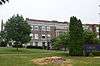
| 32 |
Somerset City School and Carnegie Library |
|
000000001978-07-07-0000July 7, 1978
(#78001393) |
300 College St.
37°05′45″N 84°36′06″W / 37.095833°N 84.601667°W / 37.095833; -84.601667 (Somerset City School and Carnegie Library) |
Somerset |
|
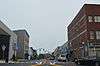
| 33 |
Somerset Downtown Commercial District |
|
000000001982-08-27-0000August 27, 1982
(#82002742) |
108-236 and 201-223 E. Mt. Vernon St.
37°05′32″N 84°36′15″W / 37.092222°N 84.604167°W / 37.092222; -84.604167 (Somerset Downtown Commercial District) |
Somerset |
|
| 34 |
South Courthouse Square Historic District |
|
000000001984-08-14-0000August 14, 1984
(#84001975) |
Public Sq., Zachary Way, W. Mt. Vernon, S. Main, and S. Maple Sts.
37°05′31″N 84°36′17″W / 37.091944°N 84.604722°W / 37.091944; -84.604722 (South Courthouse Square Historic District) |
Somerset |
|
| 35 |
US Post Office-Bronston |
|
000000001985-08-16-0000August 16, 1985
(#85001835) |
Kentucky Route 790
36°59′09″N 84°37′09″W / 36.985833°N 84.619028°W / 36.985833; -84.619028 (US Post Office-Bronston) |
Bronston |
|
| 36 |
Waddle-Prather House |
|
000000001984-08-14-0000August 14, 1984
(#84001976) |
311 N. College St.
37°05′50″N 84°36′09″W / 37.097361°N 84.602500°W / 37.097361; -84.602500 (Waddle-Prather House) |
Somerset |
|
| 37 |
West Columbia Street District |
|
000000001984-08-14-0000August 14, 1984
(#84001977) |
201-303 W. Columbia St.
37°05′32″N 84°36′24″W / 37.092222°N 84.606667°W / 37.092222; -84.606667 (West Columbia Street District) |
Somerset |
|
| 38 |
Withers House |
|
000000001984-08-14-0000August 14, 1984
(#84001978) |
116 Maple St.
37°05′37″N 84°36′15″W / 37.093611°N 84.604167°W / 37.093611; -84.604167 (Withers House) |
Somerset |
|
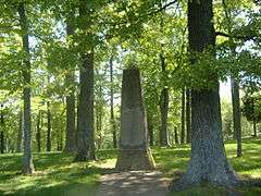
| 39 |
Gen. Felix K. Zollicoffer Monument |
|
000000001997-07-17-0000July 17, 1997
(#97000672) |
Zollicoffer Park Cemetery, 0.3 miles south of the junction of Kentucky Routes 235 and 761
37°03′20″N 84°44′22″W / 37.055556°N 84.739444°W / 37.055556; -84.739444 (Gen. Felix K. Zollicoffer Monument) |
Nancy |
|