National Register of Historic Places listings in Anderson County, Kentucky

Location of Anderson County in Kentucky
This is a list of the National Register of Historic Places listings in Anderson County, Kentucky.
This is intended to be a complete list of the properties and districts on the National Register of Historic Places in Anderson County, Kentucky, United States. The locations of National Register properties and districts for which the latitude and longitude coordinates are included below, may be seen in a map.[1]
There are 12 properties and districts listed on the National Register in the county.
- This National Park Service list is complete through NPS recent listings posted December 16, 2016.[2]
- Adair
- Allen
- Anderson
- Ballard
- Barren
- Bath
- Bell
- Boone
- Bourbon
- Boyd
- Boyle
- Bracken
- Breckinridge
- Breathitt
- Bullitt
- Butler
- Caldwell
- Calloway
- Campbell
- Carlisle
- Carroll
- Carter
- Casey
- Christian
- Clark
- Clay
- Clinton
- Crittenden
- Cumberland
- Daviess
- Edmonson
- Elliott
- Estill
- Fayette
- Fleming
- Floyd
- Franklin
- Fulton
- Gallatin
- Garrard
- Grant
- Graves
- Grayson
- Green
- Greenup
- Hancock
- Hardin
- Harlan
- Harrison
- Hart
- Henderson
- Henry
- Hickman
- Hopkins
- Jackson
- Jefferson
- Jessamine
- Johnson
- Kenton
- Knott
- Knox
- LaRue
- Laurel
- Lawrence
- Lee
- Leslie
- Letcher
- Lewis
- Lincoln
- Livingston
- Logan
- Lyon
- Madison
- Magoffin
- Marion
- Marshall
- Martin
- Mason
- McCracken
- McCreary
- McLean
- Meade
- Menifee
- Mercer
- Metcalfe
- Monroe
- Montgomery
- Morgan
- Muhlenberg
- Nelson
- Nicholas
- Ohio
- Oldham
- Owen
- Owsley
- Pendleton
- Perry
- Pike
- Powell
- Pulaski
- Robertson
- Rockcastle
- Rowan
- Russell
- Scott
- Shelby
- Simpson
- Spencer
- Taylor
- Todd
- Trigg
- Trimble
- Union
- Warren
- Washington
- Wayne
- Webster
- Whitley
- Wolfe
- Woodford
Current listings
| [3] | Name on the Register | Image | Date listed[4] | Location | City or town | Description |
|---|---|---|---|---|---|---|
| 1 | Confederate Monument in Lawrenceburg | 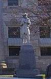 |
(#97000716) |
Courthouse Lawn, 0.5 miles south of U.S. Route 127 and Kentucky Route 44 38°02′06″N 84°53′44″W / 38.035°N 84.895556°W |
Lawrenceburg | |
| 2 | R.H. Crossfield House | Upload image | (#75000730) |
Southwest of Lawrenceburg off Anderson City Rd. 37°59′06″N 84°58′57″W / 37.985°N 84.9825°W |
Lawrenceburg | |
| 3 | Dowling House | 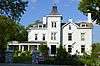 |
(#79000957) |
321 S. Main St. 38°01′59″N 84°53′40″W / 38.033056°N 84.894444°W |
Lawrenceburg | |
| 4 | Thomas H. Hanks House | 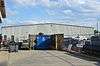 |
(#80001478) |
516 E. Woodford St. 38°02′21″N 84°53′11″W / 38.039167°N 84.886389°W |
Lawrenceburg | |
| 5 | Kavanaugh Academy | 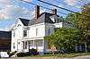 |
(#73000781) |
241 E. Woodford St. 38°02′19″N 84°53′32″W / 38.038611°N 84.892222°W |
Lawrenceburg | |
| 6 | Lawrenceburg Commercial Historic District | 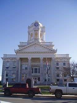 |
(#94000837) |
Roughly Main St. from North Alley to Court St. and Court from Main to the Southern Railway tracks 38°02′11″N 84°53′44″W / 38.036389°N 84.895556°W |
Lawrenceburg | |
| 7 | Lexington Extension of the Louisville Southern Railroad | 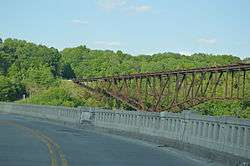 |
(#04000789) |
Eastern Lawrenceburg to Milner 38°02′08″N 84°50′00″W / 38.035556°N 84.833333°W |
Lawrenceburg | Extends into Woodford County |
| 8 | McBrayer-Clark House |  |
(#73000782) |
North of Lawrenceburg on Kentucky Route 326 38°04′06″N 84°54′19″W / 38.068333°N 84.905278°W |
Lawrenceburg | |
| 9 | Rev. William Dudley Moore House | Upload image | (#79000958) |
4 miles (6.4 km) south of Lawrenceburg 37°59′00″N 84°52′31″W / 37.983333°N 84.875278°W |
Lawrenceburg | |
| 10 | Old Prentice Distillery | 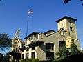 |
(#87000478) |
Kentucky Route 513 37°58′23″N 84°53′54″W / 37.973056°N 84.898333°W |
Lawrenceburg | |
| 11 | Old Wash Place | Upload image | (#75000731) |
9 miles west of Lawrenceburg at the junction of U.S. Route 62 and Kentucky Route 53 37°57′36″N 85°01′28″W / 37.96°N 85.024444°W |
Lawrenceburg | |
| 12 | T.B. Ripy House | 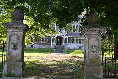 |
(#80001479) |
320 S. Main St. 38°01′58″N 84°53′44″W / 38.032778°N 84.895556°W |
Lawrenceburg |
See also
| Wikimedia Commons has media related to National Register of Historic Places in Anderson County, Kentucky. |
- List of National Historic Landmarks in Kentucky
- National Register of Historic Places listings in Kentucky
References
- ↑ The latitude and longitude information provided in this table was derived originally from the National Register Information System, which has been found to be fairly accurate for about 99% of listings. For about 1% of NRIS original coordinates, experience has shown that one or both coordinates are typos or otherwise extremely far off; some corrections may have been made. A more subtle problem causes many locations to be off by up to 150 yards, depending on location in the country: most NRIS coordinates were derived from tracing out latitude and longitudes off of USGS topographical quadrant maps created under the North American Datum of 1927, which differs from the current, highly accurate WGS84 GPS system used by most on-line maps. Chicago is about right, but NRIS longitudes in Washington are higher by about 4.5 seconds, and are lower by about 2.0 seconds in Maine. Latitudes differ by about 1.0 second in Florida. Some locations in this table may have been corrected to current GPS standards.
- ↑ "National Register of Historic Places: Weekly List Actions". National Park Service, United States Department of the Interior. Retrieved on December 16, 2016.
- ↑ Numbers represent an ordering by significant words. Various colorings, defined here, differentiate National Historic Landmarks and historic districts from other NRHP buildings, structures, sites or objects.
- ↑ The eight-digit number below each date is the number assigned to each location in the National Register Information System database, which can be viewed by clicking the number.
| Topics | |
|---|---|
| Lists by states |
|
| Lists by insular areas | |
| Lists by associated states | |
| Other areas | |
| |
Municipalities and communities of Anderson County, Kentucky, United States | ||
|---|---|---|
| City | | |
| Unincorporated communities | ||
| Ghost town | ||
This article is issued from Wikipedia - version of the 4/2/2016. The text is available under the Creative Commons Attribution/Share Alike but additional terms may apply for the media files.