| [3] |
Name on the Register[4] |
Image |
Date listed[5] |
Location |
City or town |
Description |
|---|
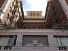
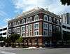
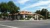
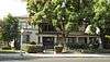
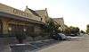
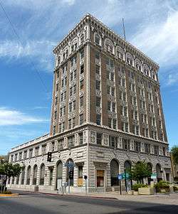
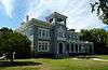
| 1 |
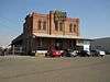
Bank of Italy |
|
000000001982-10-29-0000October 29, 1982
(#82000963) |
1015 Fulton Mall
36°44′02″N 119°47′22″W / 36.733889°N 119.789444°W / 36.733889; -119.789444 (Bank of Italy) |
Fresno |
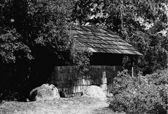
|
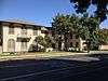
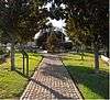
| 2 |
Ben Gefvert Ranch Historic District |
|
000000002011-01-07-0000January 7, 2011
(#10001117) |
4770 W. Whites Bridge Rd.
36°44′07″N 119°51′36″W / 36.735278°N 119.86°W / 36.735278; -119.86 (Ben Gefvert Ranch Historic District) |
Fresno |
|
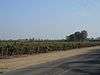
| 3 |
Big Creek Hydroelectric System Historic District |
|
000000002016-07-26-0000July 26, 2016
(#16000468) |
Roughly from Big Creek to Northern Los Angeles
37°19′23″N 119°18′58″W / 37.323056°N 119.316111°W / 37.323056; -119.316111 (Big Creek Hydroelectric System Historic District) |
Big Creek |
|
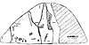
| 4 |
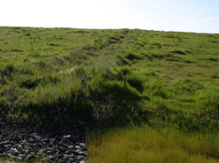
Birdwell Rock Petroglyph Site |
|
000000002003-03-12-0000March 12, 2003
(#03000117) |
Address Restricted
|
Coalinga |
|
| 5 |
H. H. Brix Mansion |
|
000000001983-09-15-0000September 15, 1983
(#83001178) |
2844 Fresno St.
36°44′31″N 119°46′56″W / 36.741944°N 119.782222°W / 36.741944; -119.782222 (H. H. Brix Mansion) |
Fresno |
|
| 6 |
Coalinga Polk Street School |
|
000000001982-05-06-0000May 6, 1982
(#82002175) |
S. 5th and E. Polk Sts.
36°08′11″N 120°21′15″W / 36.136389°N 120.354167°W / 36.136389; -120.354167 (Coalinga Polk Street School) |
Coalinga |
|
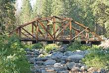
| 7 |
Dinkey Creek Bridge |
|
000000001996-09-05-0000September 5, 1996
(#96000911) |
Off Dinkey Creek Rd., W of Camp Fresno, Sierra National Forest
37°04′02″N 119°09′14″W / 37.0672°N 119.1539°W / 37.0672; -119.1539 (Dinkey Creek Bridge) |
Dinkey Creek |
|
| 8 |
Einstein House |
|
000000001978-01-31-0000January 31, 1978
(#78000662) |
1600 M St.
36°44′33″N 119°47′34″W / 36.7425°N 119.792778°W / 36.7425; -119.792778 (Einstein House) |
Fresno |
|
| 9 |
Forestiere Underground Gardens |
|
000000001977-10-28-0000October 28, 1977
(#77000293) |
5021 W. Shaw Ave.
36°48′26″N 119°52′51″W / 36.807222°N 119.880833°W / 36.807222; -119.880833 (Forestiere Underground Gardens) |
Fresno |
|
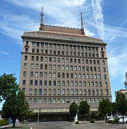
| 10 |
Fresno Bee Building |
|
000000001982-11-01-0000November 1, 1982
(#82000964) |
1555 Van Ness Ave.
36°44′25″N 119°47′41″W / 36.740278°N 119.794722°W / 36.740278; -119.794722 (Fresno Bee Building) |
Fresno |
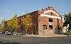
|
| 11 |
Fresno Brewing Company Office and Warehouse |
|
000000001984-01-05-0000January 5, 1984
(#84000773) |
100 M St.
36°43′38″N 119°46′32″W / 36.727222°N 119.775556°W / 36.727222; -119.775556 (Fresno Brewing Company Office and Warehouse) |
Fresno |
|
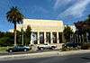
| 12 |
Fresno County Hall of Records |
|
000000002011-12-22-0000December 22, 2011
(#11000932) |
2281 Tulare St.
36°44′10″N 119°47′14″W / 36.736008°N 119.787311°W / 36.736008; -119.787311 (Fresno County Hall of Records) |
Fresno |
|
| 13 |
Fresno Memorial Auditorium |
|
000000001994-05-10-0000May 10, 1994
(#94000427) |
2425 Fresno St.
36°44′23″N 119°47′15″W / 36.739722°N 119.7875°W / 36.739722; -119.7875 (Fresno Memorial Auditorium) |
Fresno |
|
| 14 |
Fresno Republican Printery Building |
|
000000001979-01-02-0000January 2, 1979
(#79000474) |
2130 Kern St.
36°44′01″N 119°47′11″W / 36.733611°N 119.786389°W / 36.733611; -119.786389 (Fresno Republican Printery Building) |
Fresno |
|
| 15 |
Fresno Sanitary Landfill |
|
000000002001-08-07-0000August 7, 2001
(#01001050) |
West and Jensen Aves.
36°42′24″N 119°49′37″W / 36.706744°N 119.826914°W / 36.706744; -119.826914 (Fresno Sanitary Landfill) |
Fresno |
First modern landfill in the US, this closed landfill is also a Superfund site.
|
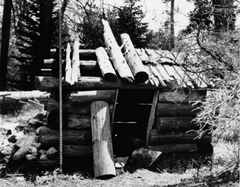
| 16 |
Gamlin Cabin |
|
000000001977-03-08-0000March 8, 1977
(#77000123) |
NW of Wilsonia
36°44′56″N 118°58′13″W / 36.748889°N 118.970278°W / 36.748889; -118.970278 (Gamlin Cabin) |
Wilsonia |
|
| 17 |
Holy Trinity Armenian Apostolic Church |
|
000000001986-07-31-0000July 31, 1986
(#86002097) |
2226 Ventura St.
36°43′54″N 119°46′54″W / 36.731667°N 119.781667°W / 36.731667; -119.781667 (Holy Trinity Armenian Apostolic Church) |
Fresno |
|
| 18 |
Hotel Californian |
|
000000002004-04-21-0000April 21, 2004
(#04000333) |
851 Van Ness Ave.
36°44′03″N 119°47′17″W / 36.734167°N 119.788056°W / 36.734167; -119.788056 (Hotel Californian) |
Fresno |
|
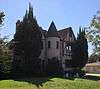
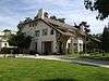
| 19 |
M. Theo Kearney Park and Mansion |
|
000000001975-03-13-0000March 13, 1975
(#75000426) |
7160 Kearney Blvd.
36°43′32″N 119°55′04″W / 36.725556°N 119.917778°W / 36.725556; -119.917778 (M. Theo Kearney Park and Mansion) |
Fresno |
|
| 20 |
Paul Kindler House |
|
000000001982-10-29-0000October 29, 1982
(#82000965) |
1520 E. Olive Ave
36°45′26″N 119°47′27″W / 36.757222°N 119.790833°W / 36.757222; -119.790833 (Paul Kindler House) |
Fresno |
|
| 21 |
Knapp Cabin |
|
000000001978-12-20-0000December 20, 1978
(#78000291) |
W of Cedar Grove in Kings Canyon National Park
36°47′02″N 118°38′09″W / 36.783889°N 118.635833°W / 36.783889; -118.635833 (Knapp Cabin) |
Cedar Grove |
|
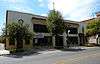
| 22 |
Maubridge Apartments |
|
000000001982-05-06-0000May 6, 1982
(#82002176) |
2344 Tulare St.
36°44′12″N 119°47′07″W / 36.736667°N 119.785278°W / 36.736667; -119.785278 (Maubridge Apartments) |
Fresno |
|
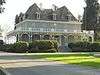
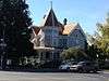
| 23 |
Meux House |
|
000000001975-01-13-0000January 13, 1975
(#75000427) |
1007 R St.
36°44′23″N 119°46′53″W / 36.739722°N 119.781389°W / 36.739722; -119.781389 (Meux House) |
Fresno |
|
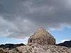
| 24 |
John Muir Memorial Shelter |
|
000000002016-08-15-0000August 15, 2016
(#16000576) |
At the top of Muir Pass in Kings Canyon National Park
37°06′43″N 118°40′15″W / 37.112027°N 118.670922°W / 37.112027; -118.670922 (John Muir Memorial Shelter) |
Grant Cove vicinity |
|
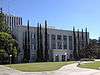
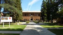
| 25 |
Old Administration Building, Fresno City College |
|
000000001974-05-01-0000May 1, 1974
(#74000510) |
1101 University Ave.
36°46′04″N 119°47′51″W / 36.767778°N 119.7975°W / 36.767778; -119.7975 (Old Administration Building, Fresno City College) |
Fresno |
|
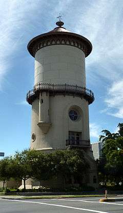
| 26 |
Old Fresno Water Tower |
|
000000001971-10-14-0000October 14, 1971
(#71000139) |
2444 Fresno St.
36°44′21″N 119°47′11″W / 36.739167°N 119.786389°W / 36.739167; -119.786389 (Old Fresno Water Tower) |
Fresno |
|
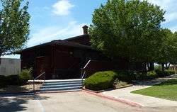
| 27 |
Orange Cove Santa Fe Railway Depot |
|
000000001978-08-29-0000August 29, 1978
(#78000668) |
633 E. Railroad Ave.
36°37′23″N 119°18′42″W / 36.623056°N 119.311667°W / 36.623056; -119.311667 (Orange Cove Santa Fe Railway Depot) |
Orange Cove |
|
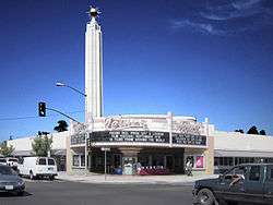
| 28 |
Alexander Pantages Theater |
|
000000001978-02-23-0000February 23, 1978
(#78000663) |
1400 Fulton St.
36°44′17″N 119°47′40″W / 36.738056°N 119.794444°W / 36.738056; -119.794444 (Alexander Pantages Theater) |
Fresno |
|
| 29 |
Physicians Building |
|
000000001978-11-20-0000November 20, 1978
(#78000664) |
2607 Fresno St.
36°44′26″N 119°47′06″W / 36.740556°N 119.785°W / 36.740556; -119.785 (Physicians Building) |
Fresno |
|
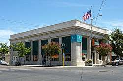
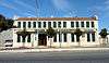
| 30 |
Reedley National Bank |
|
000000001985-02-28-0000February 28, 1985
(#85000352) |
1100 G St.
36°35′47″N 119°26′58″W / 36.596389°N 119.449444°W / 36.596389; -119.449444 (Reedley National Bank) |
Reedley |
|
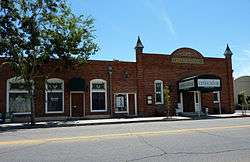
| 31 |
Reedley Opera House Complex |
|
000000001984-04-05-0000April 5, 1984
(#84000774) |
10th and G Sts.
36°35′49″N 119°27′03″W / 36.596944°N 119.450833°W / 36.596944; -119.450833 (Reedley Opera House Complex) |
Reedley |
|
| 32 |
Rehorn House |
|
000000001982-01-08-0000January 8, 1982
(#82002177) |
1050 S St.
36°44′29″N 119°46′50″W / 36.741389°N 119.780556°W / 36.741389; -119.780556 (Rehorn House) |
Fresno |
|
| 33 |
Frank Romain House |
|
000000001982-01-11-0000January 11, 1982
(#82002178) |
2055 San Joaquin St.
36°44′30″N 119°47′46″W / 36.741667°N 119.796111°W / 36.741667; -119.796111 (Frank Romain House) |
Fresno |
|
| 34 |
San Joaquin Light & Power Corporation Building |
|
000000002006-01-03-0000January 3, 2006
(#05001497) |
1401 Fulton St.
36°44′13″N 119°47′41″W / 36.736944°N 119.794722°W / 36.736944; -119.794722 (San Joaquin Light & Power Corporation Building) |
Fresno |
|
| 35 |
Santa Fe Hotel |
|
000000001991-03-14-0000March 14, 1991
(#91000287) |
935 Santa Fe Ave.
36°44′16″N 119°46′56″W / 36.737778°N 119.782222°W / 36.737778; -119.782222 (Santa Fe Hotel) |
Fresno |
|
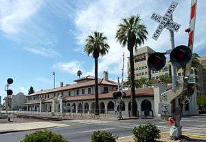
| 36 |
Santa Fe Passenger Depot |
|
000000001976-11-07-0000November 7, 1976
(#76000482) |
2650 Tulare St.
36°44′18″N 119°46′55″W / 36.738333°N 119.781944°W / 36.738333; -119.781944 (Santa Fe Passenger Depot) |
Fresno |
|
| 37 |
Shorty Lovelace Historic District |
|
000000001978-01-31-0000January 31, 1978
(#78000293) |
E of Pinehurst on Kings Canyon National Park
36°44′26″N 118°31′03″W / 36.740556°N 118.5175°W / 36.740556; -118.5175 (Shorty Lovelace Historic District) |
Pinehurst |
A series of cabins built by trapper Shorty Lovelace.
|
| 38 |
Southern Pacific Passenger Depot |
|
000000001978-03-21-0000March 21, 1978
(#78000665) |
1033 H St.
36°43′57″N 119°47′33″W / 36.7325°N 119.7925°W / 36.7325; -119.7925 (Southern Pacific Passenger Depot) |
Fresno |
|
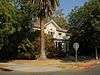
| 39 |
Stoner House |
Upload image |
000000001985-10-17-0000October 17, 1985
(#85003145) |
21143 E. Welson Ave.
36°45′57″N 119°24′26″W / 36.765833°N 119.407222°W / 36.765833; -119.407222 (Stoner House) |
Sanger |
|
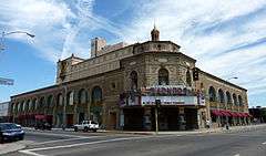
| 40 |
Tower Theatre |
|
000000001992-09-24-0000September 24, 1992
(#92001276) |
1201 N. Wishon Ave.
36°45′28″N 119°48′05″W / 36.7579°N 119.8014°W / 36.7579; -119.8014 (Tower Theatre) |
Fresno |
|
| 41 |
Twining Laboratories |
|
000000001991-03-26-0000March 26, 1991
(#91000308) |
2527 Fresno St.
36°45′29″N 119°47′12″W / 36.758056°N 119.786667°W / 36.758056; -119.786667 (Twining Laboratories) |
Fresno |
|
| 42 |
Warehouse Row |
|
000000001978-03-24-0000March 24, 1978
(#78000666) |
722, 744, and 764 P St.
36°44′10″N 119°46′40″W / 36.736111°N 119.777778°W / 36.736111; -119.777778 (Warehouse Row) |
Fresno |
|
| 43 |
Y.W.C.A. Building |
|
000000001978-09-21-0000September 21, 1978
(#78000667) |
1660 M St.
36°44′35″N 119°47′35″W / 36.743056°N 119.793056°W / 36.743056; -119.793056 (Y.W.C.A. Building) |
Fresno |
|


.jpg)