Huntington Lake, California
Coordinates: 37°13′54″N 119°14′09″W / 37.23167°N 119.23583°W
| Huntington Lake | |
|---|---|
| Unincorporated community | |
 Huntington Lake  Huntington Lake Location in California | |
| Coordinates: 37°13′54″N 119°14′09″W / 37.23167°N 119.23583°W | |
| Country | United States |
| State | California |
| County | Fresno County |
| Elevation[1] | 7,027 ft (2,142 m) |
Huntington Lake (formerly, Basin)[2] is an unincorporated community in Fresno County, California.[1] It is located on the west end of Huntington Lake 2 miles (3.2 km) north of Big Creek,[2] at an elevation of 7027 feet (2142 m).[1]
The Basin post office opened in 1913, the name was changed to Huntington Lake in 1916.[2]
Climate
This region experiences warm (but not hot) and dry summers, with no average monthly temperatures above 71.6 °F. According to the Köppen Climate Classification system, Huntington Lake has a warm-summer Mediterranean climate, abbreviated "Csb" on climate maps.[3]
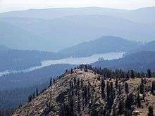
Kaiser Peak overlooks Huntington Lake in California. This photo is looking southwest from the peak. The peak has an elevation of 9,865 feet. The lake elevation when full is 6,949 feet.
References
- 1 2 3 U.S. Geological Survey Geographic Names Information System: Huntington Lake, California
- 1 2 3 Durham, David L. (1998). California's Geographic Names: A Gazetteer of Historic and Modern Names of the State. Clovis, Calif.: Word Dancer Press. p. 1049. ISBN 1-884995-14-4.
- ↑ Climate Summary for Huntington Lake, California

This article is issued from Wikipedia - version of the 7/5/2016. The text is available under the Creative Commons Attribution/Share Alike but additional terms may apply for the media files.