Mulgrave River
| Mulgrave | |
| River | |
 The Mulgrave River in the Goldsbrough Valley | |
| Country | Australia |
|---|---|
| State | Queensland |
| Region | Far North Queensland |
| Tributaries | |
| - right | Russell River |
| Primary source | Bellenden Ker Range |
| Secondary source | West Mulgrave River |
| - location | west of Babinda |
| - elevation | 376 m (1,234 ft) |
| - coordinates | 17°21′16″S 145°46′52″E / 17.35444°S 145.78111°E |
| Additional source | East Mulgrave River |
| - location | below South Peak |
| - elevation | 665 m (2,182 ft) |
| - coordinates | 17°17′37″S 145°51′00″E / 17.29361°S 145.85000°E |
| Source confluence | West and East bracnhes of the Mulgrave River |
| - location | south of Little Mulgrave |
| - elevation | 120 m (394 ft) |
| - coordinates | 17°17′50″S 145°48′01″E / 17.29722°S 145.80028°E |
| Mouth | Coral Sea |
| - location | Mutchero Inlet |
| - elevation | 0 m (0 ft) |
| - coordinates | 17°13′18″S 145°58′30″E / 17.22167°S 145.97500°ECoordinates: 17°13′18″S 145°58′30″E / 17.22167°S 145.97500°E |
| Length | 70 km (43 mi) |
| Basin | 1,315 km2 (508 sq mi) |
| National parks | Wooroonooran National Park; Russell River National Park |
 Location of Mulgrave River river mouth in Queensland | |
| Wikimedia Commons: Mulgrave River | |
| [1][2][3][4] | |
The Mulgrave River, incorporating the East Mulgrave River and the West Mulgrave River, is a river system located in Far North Queensland, Australia. The 70-kilometre (43 mi)-long river flows towards the Coral Sea and is located approximately 50 kilometres (31 mi) south of Cairns.
Location and features
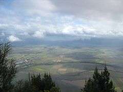
Sourced by runoff from the Bellenden Ker Range, the headwaters of the Mulgrave River rise as the east and west branches of the river below South Peak and west of Babinda respectively. The two branches form their confluence within the Wooroonooran National Park and the Wet Tropics World Heritage Area. The Mulgrave River flows generally north towards Little Mulgrave and through the outskirts of Gordonvale and flows through the Goldsbrough Valley. From Gordonvale the river flows east by south and then south where the Mulgrave River empties into the Coral Sea 30 kilometres (19 mi) south at the southern extremity of the Yarrabah Hills range where the Mulgrave meets the Russell River. The Trinity Inlet was once the river mouth of the Mulgrave River.[5] Volcanic activity that resulted in the rise of Green Hill in the Mulgrave Valley blocked the river from entering the sea near present-day Cairns.
The river has a catchment area of 1,315 square kilometres (508 sq mi).[4] From source to mouth, incorporating the east and west branches of the river, the river descends 665 metres (2,182 ft) over a combined 78 kilometres (48 mi) course.[1][2][3]
The river is crossed by the Bruce Highway south of Gordonvale via the Desmond Trannore Bridge.
Gold was discovered in the river in the 1870s, bringing considerable change to the Goldsbrough Valley. Gravel is now extracted from the riverbed.[4]
Freshwater stonefish and crocodiles are found in the river, so caution is advised if swimming in the river. The pest fish tilapia have been discovered in the river and been the target of eradication efforts.[6]
Together with the Russell River, the Mulgrave River has a quite well recorded flood history with documented evidence of flooding beginning in the late 1930s.[7]
See also
References
- 1 2 "Map of Mulgrave River, QLD". Bonzle Digital Atlas of Australia. Retrieved 20 October 2015.
- 1 2 "Map of East Mulgrave River, QLD". Bonzle Digital Atlas of Australia. Retrieved 21 October 2015.
- 1 2 "Map of West Mulgrave River, QLD". Bonzle Digital Atlas of Australia. Retrieved 21 October 2015.
- 1 2 3 "Water resources - Overview - Queensland - Basin & Surface Water Management Area: Musgrave River". Australian Natural Resources Atlas. Department of the Environment, Water, Heritage and the Arts. Retrieved 21 May 2009.
- ↑ "Chapter 2:The Cairns Setting" (PDF). Geoscience Australia. Australian Government.
- ↑ Stephen, Adam (14 September 2009). "Terminating Talapia". ABC Rural. Australian Broadcasting Corporation. Retrieved 21 May 2009.
- ↑ "Flood Warning System for the Mulgrave and Russell Rivers". Bureau of Meteorology. Australia: Australian Government. Retrieved 21 October 2015.
Rivers of Queensland | |||||||||||||||||||||||||
|---|---|---|---|---|---|---|---|---|---|---|---|---|---|---|---|---|---|---|---|---|---|---|---|---|---|
| |||||||||||||||||||||||||
| |||||||||||||||||||||||||
| |||||||||||||||||||||||||
| |||||||||||||||||||||||||
| |||||||||||||||||||||||||
| |||||||||||||||||||||||||