Mooloolah River
| Mooloolah | |
| River | |
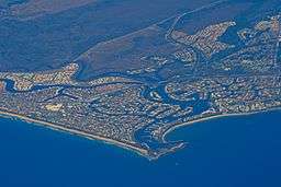 Aerial photo of Mooloolaba showing river mouth and canals, 2007 | |
| Country | Australia |
|---|---|
| State | Queensland |
| Region | South East Queensland |
| Source | Blackall Range |
| Mouth | Mooloolaba |
| Length | 69.8 km (43 mi) |
| Basin | 221 km2 (85 sq mi) |
The Mooloolah River is a river in South East Queensland, Australia. The river rises from the eastern slopes of the Blackall Range and flows east-northeast, similar to the Maroochy River to the north. The mouth of the river is at southern Mooloolaba. The catchment area covers 221 km2.[1]
Addlington Creek, a tributary of the Mooloolah River was dammed by the Ewen Maddock Dam in 1973. Mountain Creek is another tributary that rises on the Buderim mountain that divides the Mooloolah and Maroochy watersheds.
The gastric-brooding frog is a recently extinct frog that was discovered in only three catchments, the Mary River, Mooloolah River and Stanley Rivers.
Although the Mooloolah River doesn't experience major flooding often, a flood warning system was established in 2004 to inform the Sunshine Coast Regional Council with river height predictions from network of rainfall and river height field stations.[2]
See also
References
- ↑ "Mooloolah River". State of the Rivers report. Department of Environment and Resource Management. 2008-10-23. Retrieved 2009-05-25.
- ↑ "Flood Warning System For The Mooloolah River". Bureau of Meteorology (Australia). Retrieved 2009-05-25.
Rivers of Queensland | |||||||||||||||||||||||||
|---|---|---|---|---|---|---|---|---|---|---|---|---|---|---|---|---|---|---|---|---|---|---|---|---|---|
| |||||||||||||||||||||||||
| |||||||||||||||||||||||||
| |||||||||||||||||||||||||
| |||||||||||||||||||||||||
| |||||||||||||||||||||||||
| |||||||||||||||||||||||||
Coordinates: 26°42′S 153°09′E / 26.700°S 153.150°E