Central Queensland
| Central Queensland Queensland | |
|---|---|
 The Regions of Queensland | |
| Population | 233,931 (2011 census)[1] |
| LGA(s) | |
| State electorate(s) | |
| Federal Division(s) | Capricornia |
Central Queensland is an ambiguous geographical division of Queensland (a state in Australia) that centres on the eastern coast, around the Tropic of Capricorn. Its major regional centre is Rockhampton. The region extends from the Capricorn Coast west to the Central Highlands at Emerald, north to the Mackay Regional Council southern boundary, and south to Gladstone. The region is also known as Capricornia. It is one of Australia's main coal exporting regions.
At the 2011 Australian Census the region recorded a total population from the six local government areas of 233,931.[1]
Industry

Economically, Central Queensland is an important centre of primary industries, particularly for food and fibre production.[2] Central Queensland includes the Bowen Basin which is rich in high quality coking coal, the Port of Gladstone produces 40% of the state's export earnings, the Fitzroy River is the second-largest river system in Australia and commands significant water resources such as Fairbairn Dam. Gladstone has a significant aluminium smelter.
Beef
Rockhampton is claimed to be the beef capital of Australia, a title which is disputed by Casino in New South Wales.[3] Beef production in the region is centered on Brigalow and speargrass land types.[4] There are three abattoirs in the region.[2]
Mining

Central Queensland is one of the world's leading producers and exporters of black coal.[5] Ludwig Leichhardt was the first European to discover coal deposits in the region in 1845.[6] In the 2011-2012 financial year the region produced 40% of the state's total coal production.[7]
Coal is extracted from the Bowen Basin and transported to port facilities at Port of Gladstone via the Blackwater railway system or to both Hay Point and Abbot Point via the Goonyella railway line. Coal mining is expanding west into the Galilee Basin and requires an extension of the Goonyella line to transport coal to port. Many mines in the region, particularly those within the Fitzroy River basin, were severely impacted by flooding during the 2010–11 Queensland floods.[8]
Gold, silver, limestone, coal seam gas, magnesite and gemstones are also mined.[5] Sapphires were discovered here in 1875.[9] Gold was discovered in the Mount Morgan region around 1865. Mount Morgan Mine has since gone on to become one of Australia's richest mines.[10]
Purpose built mining towns in Central Queensland include Dysart, Middlemount, Moranbah, Mount Morgan and Moura. Three mining disaster have occurred at Moura since 1975, resulting in the loss of 36 lives.[11]
Citrus canker outbreak
In 2004, an orchard on Evergreen farm was the site of the first detection of citrus canker in Central Queensland. A significant part of the citrus growing industry was devastated when a total of 6,000 acres (24 km2) of crop had to be destroyed so the disease would not spread across the country.[12] In 2005 several fresh outbreaks were reported so the eradication expanded to include private backyard trees.[13] The outbreak's cause has not been fully explained despite a federal inquiry.[12] In 2009 authorities from the Government of Queensland declared the eradication program complete.
Protected areas
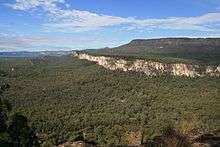

The region contain 33 national parks. Great Keppel Island has been an island tourist attraction since the 1960s. It and several other islands in the area are surrounded by coral reefs.[14] In the west of the region is Queensland's central highlands and the Carnarvon Gorge, which is protected within the Carnarvon National Park. Carnarvon Gorge features white sandstone cliffs, steep-sided gorges a diverse range of significant plant and animal species and many walking tracks.[15] Kroombit Tops National Park provides habitat for the endemic Kroombit tinker frog. Deepwater National Park is good place for turtle watching. From November to March three species of turtle lay their eggs on beaches protected within the park.[16]
Communities
For this purpose the area of Central Queensland was restricted to the areas encircled by the Dawson Highway between Gladstone and Springsure; the Gregory Highway between Springsure and Clermont, and the Peak Downs Highway between Clermont and enters North Queensland via Mackay - extended right to the eastern coastline.
Major cities in the region are Emerald, Gladstone and Rockhampton. Some communities on the Capricorn Coast include Byfield, Yeppoon, Great Keppel Island, Emu Park and Cawarral.
Education
Central Queensland University has a campus at Emerald, Gladstone and Rockhampton.
See also
References
- 1 2 "Census data". 2011 Census of Population and Housing. Australian Bureau of Statistics. Retrieved 3 August 2014.
- 1 2 "An Overview of Food and Fibre Industries in Central Queensland" (PDF). Regional Development Australia. Retrieved 20 June 2014.
- ↑ Paul Robinson, Elloise Farrow-Smith & Miranda Saunders (17 April 2014). "An ownership row has erupted over who holds Australia's Beef Capital title". ABC News. Australian Broadcasting Corporation. Retrieved 19 June 2014.
- ↑ "The economics of beef in Central Queensland" (PDF). Department of Primary Industries and Fisheries. Retrieved 20 June 2014.
- 1 2 "Central Queensland information and maps". Department of Natural Resources and Mines. The State of Queensland. 27 February 2014. Retrieved 19 June 2014.
- ↑ "Coal Mining in Blackwater". Blackwater International Coal Centre. Retrieved 3 August 2014.
- ↑ "Central Queensland Regional Plan". Department of Infrastructure, Local Government and Planning. 24 April 2015. Retrieved 26 April 2015.
- ↑ "Return to full production for flood affected mines in Central Queensland". Queensland Reconstruction Authority. Queensland Government. Retrieved 19 June 2014.
- ↑ "History of the Sapphire Industry - Central Queensland". Australian Sapphire. Retrieved 19 June 2014.
- ↑ "Mount Morgan Mine Site (entry 600751)". Queensland Heritage Register. Queensland Heritage Council. Retrieved 19 June 2014.
- ↑ "Moura inquiries". The State of Queensland. Retrieved 3 August 2014.
- 1 2 "Spot of Trouble". Landline. 29 March 2009.
- ↑ "Citrus canker outbreak to impact on residents". ABC News Online. Australian Broadcasting Corporation. 7 September 2005. Retrieved 29 March 2008.
- ↑ "About Keppel Bay Islands". Department of National Parks, Recreation, Sport and Racing. 6 January 2014. Retrieved 19 June 2014.
- ↑ "About Carnarvon Gorge". Department of National Parks, Recreation, Sport and Racing. Retrieved 19 June 2014.
- ↑ "Nature, culture and history". Department of National Parks, Recreation, Sport and Racing. Retrieved 19 June 2014.
External links
![]() Media related to Central Queensland at Wikimedia Commons
Media related to Central Queensland at Wikimedia Commons
| Topics | ||
|---|---|---|
| Regions | ||
| Cities and towns | ||
| ||
Coordinates: 23°26′22.97″S 144°53′09.69″E / 23.4397139°S 144.8860250°E