Endeavour River
| Endeavour (Wabalumbaal) | |
| Endeavours | |
| River | |
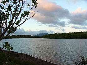 Endeavour River at Marton, 2004 | |
| Name origin: HMS Endeavour[1] | |
| Country | Australia |
|---|---|
| State | Queensland |
| Region | Far North Queensland |
| Primary source | Endeavour River Right Branch |
| - location | northwest of Hopevale |
| - elevation | 327 m (1,073 ft) |
| - coordinates | 15°15′17″S 145°03′01″E / 15.25472°S 145.05028°E |
| Secondary source | Endeavour River North Branch |
| - location | below Honeysuckle Flat |
| - elevation | 160 m (525 ft) |
| - coordinates | 15°20′50″S 145°06′11″E / 15.34722°S 145.10306°E |
| Additional source | Endeavour River South Branch |
| - location | near Alderbury |
| - elevation | 109 m (358 ft) |
| - coordinates | 15°25′25″S 144°54′54″E / 15.42361°S 144.91500°E |
| Source confluence | Right Branch to from the Endeavour River |
| - location | Endeavour River National Park |
| - coordinates | 15°26′34″S 145°12′12″E / 15.44278°S 145.20333°E |
| Mouth | Coral Sea |
| - location | Cooktown |
| - elevation | 0 m (0 ft) |
| - coordinates | 15°27′23″S 145°14′59″E / 15.45639°S 145.24972°ECoordinates: 15°27′23″S 145°14′59″E / 15.45639°S 145.24972°E |
| Length | 140 km (87 mi) |
| Basin | 1,315 km2 (508 sq mi) |
| National park | Endeavour River National Park |
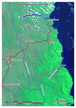 Satellite image of the Endeavour River course marked in dark blue | |
| Wikimedia Commons: Endeavour River | |
| [2][3][4][5] | |
The Endeavour River (Guugu Yimithirr: Wabalumbaal), inclusive of the Endeavour River Right Branch, the Endeavour River South Branch, and the Endeavour River North Branch, is a river system located on Cape York Peninsula in Far North Queensland, Australia.
Course and features
The river system comprises three branches that are sourced by runoff from the Henderson and Audaer Ranges. The river flows generally east from the Great Dividing Range to the Coral Sea. The Right Branch of the river rises northwest of Hopevale at an elevation of 335 metres (1,099 ft) and flows generally south by east for 48 kilometres (30 mi) before reaching its confluence to join with the Endeavour River northwest of Cooktown, and west of the river mouth.[3] The South Branch of the river rises near Alderbury at an elevation of 109 metres (358 ft) and flows generally east for 20 kilometres (12 mi) before forming confluence with the North Branch to form the Endeavour River.[4] The North Branch of the river rises below Honeysuckle Flat at an elevation of 160 metres (520 ft) and flows generally west and then south for 20 kilometres (12 mi) before forming confluence with the South Branch to form the Endeavour River.[5] Having being formed by the South and North Branches, the Endeavour River rises below Flaggy at an elevation of 39 metres (128 ft) and flows generally east towards its mouth with the Coral Sea at Cooktown, flowing through the Endeavour River National Park for the last few kilometres of its course.[2] The Endeavour River has a catchment area of 1,315 square kilometres (508 sq mi).[6]
In recent years, tilapia fish, which are considered an "invasive species" in Australia, have infested the river, causing concern that the stocks of native fish will suffer.
The river basin remains largely unmodified and the water quality is rated as good.[7]
History
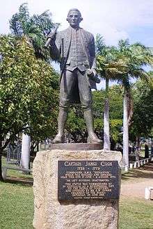
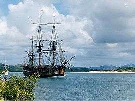
James Cook, RN named the river in 1770 after he was forced to beach his ship, HMS Endeavour,[1] for repairs in the river mouth, after damaging it on Endeavour Reef.[8] Joseph Banks named the river the Endeavours River[9] but the form Cook used, Endeavour River, has stuck.
Cook and his crew remained for almost seven weeks and made contact with the local Guugu Yimithirr Aborigines, while the naturalists Joseph Banks and Daniel Solander made extensive collections of native flora, while Sydney Parkinson illustrated much of the flora and fauna of the region. Botanical specimens were also collected by Alan Cunningham after he arrived on the HMS Mermaid, captained by Philip Parker King on 28 June 1819.
Modern Cooktown which has a population of about 2,000, is located at the mouth of the Endeavour River. It is one of the northernmost towns on the East Coast of Australia and was founded in 1873, around the site of Cook's landing, as a port to service the newly discovered Palmer River Goldfields. Some of the relatively undisturbed natural features near the mouth of the river have been reserved in the Endeavour River National Park.
See also
References
- 1 2 Shay, John; Shay, Bev (eds.). The Endeavour at the Endeavour: Cook's and Bank's journals from 11 June to 4 August 1770. Cooktown and District Historical Society.
- 1 2 "Map of Endeavour River, QLD". Bonzle Digital Atlas of Australia. Retrieved 27 October 2015.
- 1 2 "Map of Endeavour River Right Branch, QLD". Bonzle Digital Atlas of Australia. Retrieved 27 October 2015.
- 1 2 "Map of Endeavour River South Branch, QLD". Bonzle Digital Atlas of Australia. Retrieved 27 October 2015.
- 1 2 "Map of Endeavour River North Branch, QLD". Bonzle Digital Atlas of Australia. Retrieved 27 October 2015.
- ↑ Howley, Christina; Brooks, Andrew; Olley, Jon; Carroll, Jason (March 2012). Annan and Endeavour River Freshwater and Estuarine Water Quality Report: An Assessment of Ambient Water Quality and Effects of Land Use: 2002 - 2009 (PDF). Cooktown, Queensland: Cape York Marine Advisory Group Incorporated. p. 11. Retrieved 23 October 2015.
- ↑ "Assessment of River Condition - Endeavour River". Australian Natural Resources Atlas. Department of Sustainabililty, Environment, Water, Population and Communities. 6 May 2009. Retrieved 15 August 2011.
- ↑ Collingridge, Vanessa (February 2003). Captain Cook: The Life, Death and Legacy of History's Greatest Explorer. Ebury Press. ISBN 0-09-188898-0.
- ↑ The Endeavour Journal of Sir Joseph Banks
Bibliography
Rivers of Queensland | |||||||||||||||||||||||||
|---|---|---|---|---|---|---|---|---|---|---|---|---|---|---|---|---|---|---|---|---|---|---|---|---|---|
| |||||||||||||||||||||||||
| |||||||||||||||||||||||||
| |||||||||||||||||||||||||
| |||||||||||||||||||||||||
| |||||||||||||||||||||||||
| |||||||||||||||||||||||||