Archer River
| Archer | |
| River | |
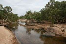 Archer River, Cape York | |
| Country | Australia |
|---|---|
| State | Queensland |
| Region | Far North Queensland |
| Tributaries | |
| - left | Coen River |
| - right | The Dry River |
| Settlement | Aurukun |
| Source | McIlwraith Range |
| - location | north of Coen |
| - elevation | 138 m (453 ft) |
| Mouth | Gulf of Carpentaria |
| - location | Archer Bay |
| - elevation | 0 m (0 ft) |
| - coordinates | 13°25′12″S 141°43′9″E / 13.42000°S 141.71917°ECoordinates: 13°25′12″S 141°43′9″E / 13.42000°S 141.71917°E |
| Length | 268 km (167 mi) |
| Basin | 13,820 km2 (5,336 sq mi) |
| Discharge | |
| - average | 222 m3/s (7,840 cu ft/s) |
| National park | Mungkan Kandju National Park |
 Location of Archer River mouth in Queensland
| |
| [1] | |
The Archer River is a river located on the Cape York Peninsula, Far North Queensland, Australia.
Course and features
The headwaters of the river rise in the McIlwraith Range and flows west, it traverses tropical savanna plains and wetlands, flowing through Piccaninny Plains Sanctuary and Mungkan Kandju National Park, and enters the Archer Bay in the Gulf of Carpentaria on the western side of the peninsula near the town of Aurukun along with the Watson River and the Ward River.
The catchment area for the Archer River is 13,820 square kilometres (5,336 sq mi).[2] During the wet season between November and April, the river floods, replenishing over a million hectares of wetlands.[3] The Coen River is a tributary of the Archer River.
The river remains in a natural state with very little development and just one small dam that supplies water for the town of Coen.[2] On 3 April 2009, Queensland Premier Anna Bligh announced the Archer River would be included under the Wild Rivers Act, 2005 (Qld).[4] The declaration means the river's fragile ecosystems will be protected by allowing only sustainable activities within its catchment.
The river has an annual average discharge of 7,010 gigalitres (9.169×10⁹ cu yd) per annum.[5]
Flora and fauna
Much of the river is bordered by fig-dominated gallery rainforests which provide habitat for animals such as the white-tailed rat, spotted cuscus and palm cockatoo. Toothless catfish are found in the river.
A total of 45 species of fish have been found in the river, including the glassfish, barred grunter, silver Cobbler, Fly-specked hardyhead, mouth almighty, goby, barramundi, oxeye herring, eastern rainbowfish, bony bream, gulf saratoga, giant gudgeon, freshwater longtom and seven-spot archerfish.[6]
History
The traditional owners of the area are the Wik peoples,[7] Kandju[8] and Wikampama peoples.[9] The river was named in 1865 by Francis Lascelles Jardine and Alexander Jardine during an expedition through the area. They named the river after the Archer family of Grassmere in Rockhampton. The river had probably been named Dubbelde Ree by Willem Jansz in 1606 and later named Coen River by Jan Carstensz in 1623 and then named Peach River by Robert Logan Jack in 1879.[10]
See also
References
- ↑ "Map of Archer River, QLD". Bonzle Digital Atlas of Australia. Retrieved 6 June 2015.
- 1 2 "Water resources - Overview - Queensland - Archer River". Australian Natural Resources Atlas. Department of the Environment, Water, Heritage and the Arts. Archived from the original on 22 June 2009. Retrieved 17 May 2009.
- ↑ Wild Rivers: Archer River
- ↑ "Divisions run deep in Qld Wild Rivers debate". ABC News. Australian Broadcasting Corporation. 20 April 2009. Archived from the original on 21 April 2009. Retrieved 17 May 2009.
- ↑ Smith, Murray; Hafeez, Mohsin. "Optimising Australia's contribution to Asia's food bowl" (PDF). Retrieved 9 May 2015.
- ↑ "Archer River catchment". Fish Atlas of North Australia. Retrieved 27 June 2015.
- ↑ "Wik-Munkan". AusAnthrop Australian Aboriginal tribal database. AusAnthrop. Archived from the original on 26 September 2015. Retrieved 14 June 2015.
- ↑ "Kandju". AusAnthrop Australian Aboriginal tribal database. AusAnthrop. Retrieved 14 June 2015.
- ↑ "Wikampama". AusAnthrop Australian Aboriginal tribal database. AusAnthrop. Retrieved 14 June 2015.
- ↑ "Coen River (entry 764)". Queensland Place Names. Queensland Government. Retrieved 14 June 2014.
Rivers of Queensland | |||||||||||||||||||||||||
|---|---|---|---|---|---|---|---|---|---|---|---|---|---|---|---|---|---|---|---|---|---|---|---|---|---|
| |||||||||||||||||||||||||
| |||||||||||||||||||||||||
| |||||||||||||||||||||||||
| |||||||||||||||||||||||||
| |||||||||||||||||||||||||
| |||||||||||||||||||||||||