Buderim
| Buderim Sunshine Coast, Queensland | |
|---|---|
| Population | 39,911 (2006 census)[1] |
| • Density | 643.7/km2 (1,667.2/sq mi) |
| Postcode(s) | 4556 |
| Area | 62.0 km2 (23.9 sq mi) |
| Time zone | AEST (UTC+10) |
| Location |
|
| LGA(s) | Sunshine Coast Region |
| State electorate(s) | Buderim, Kawana, Glass House |
| Federal Division(s) | Fairfax, Fisher |
Buderim is an urban centre on the Sunshine Coast, Queensland, Australia.[2] It sits on a 180-metre (590 ft) mountain which overlooks the southern Sunshine Coast communities.
The name "Buderim" is from the local Kabi Kabi Aboriginal word for the hairpin honeysuckle, (Badderam) Banksia spinulosa var. collina, which grew abundantly in the sandy country around the plateau.[2]
History

Buderim was seen as a resource for timbergetters, as huge stands of Beech and Australian Red Cedar grew across the mountain. Some trees were so large they were wasted due to the lack of transport to carry them down to the river for despatch to Brisbane. Once clear felled, the plateau was used for farming. The rich red volcanic soil found on Buderim made the area particularly suited to growing almost everything, from bananas to small crops. The most notable were coffee and (in the 20th century) ginger, the crop which made Buderim famous. The farming pioneer Burnett won awards for the quality of his coffee at shows in London during the late 19th century.
Buderim Mountain Post Office opened on 1 June 1884 (a receiving office had been open from 1874). It was renamed Buderim by 1897.[3]
In the middle of the 20th century the largest ginger processing facility in the southern hemisphere was built, and operated as the Buderim Ginger Factory until it closed and operations were moved closer to other ginger growing areas near Yandina.
As the value of their produce was eroded, many farmers left the land to find work elsewhere. This was very much the fate of the Lindsay family, who farmed massive orchards around the road which now bears their name.
In recent times, the value of Buderim as real estate, largely due to its altitude, its proximity to the Sunshine Coast beaches and its pleasant climate, has soared, and this has pressured many others out of the rural lifestyle, as housing development increased in and around Buderim Mountain. Thanks to the huge leap in real estate values during the first decade of 2000, steep land was developed that was previously deemed too expensive to engineer for housing. Due to these developments, the remainder of the farming land and much of the secondary growth rainforest on the escarpment has disappeared. Substantial rainforest remnants remain, especially in the protected area known as the Foote Sanctuary which provides well-maintained public walking paths and BBQ facilities. There is also access to the Buderim Falls. The area is home to an abundance of native wildlife, notably king parrots and lorikeets. Brush turkeys are also a common sight, as are families of kangaroos and wallabies.

Nowadays, the Mountain is notable for the enormous variety of its architectural styles, which range from the classic 'Queenslander' to ultra-modern one-off designs. Some homes, especially those 'on top' with ocean views, sell for seven-figure sums. One celebrated 'mansion', straddling four blocks, has recently been on the market for 'offers over $20 million'.

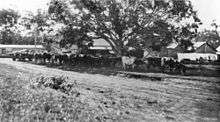
Buderim contains a significant heritage relic of the early days in the form of Pioneer Cottage, restored and cared for by the Buderim Historical Society. Between 1914 and 1935 a small gauge railway ran from Buderim to Palmwoods, to take produce from Buderim farms to market. The railway was closed down in 1935 when improved roads and truck transport made it economically redundant. A substantial section of the old track has been cleared and now provides a fine scenic walking trail running parallel to Mons Road.[4] The magnificent old Krauss steam locomotive which previously hauled the carriages along this track is currently undergoing restoration and is planned for public display in the centre of Buderim, when sufficient funds are raised.[5]
Heritage listings
Buderim has a number of heritage-listed sites, including:
- 5 Ballinger Crescent: Pioneer Cottage[6]
- 12 Dixon Road: Canambie Homestead[7]
- 10 Orme Road: Buderim House[8]
- Telco Road: Palmwoods-Buderim Tramway[9]
Geography
Buderim is not strictly defined, but the Australian Bureau of Statistics currently classifies Buderim based on the boundaries of the following suburbs:
Historically, until the 2001 census, a section of Buderim within about 1 kilometre (0.62 mi) of Sunshine Motorway, as well as Mountain Creek, were considered parts of the neighbouring Maroochydore urban centre.
Transport
Buderim's suburbs are served by Sunbus Sunshine Coast, who operate a transfer station at Buderim Market Place, and a bus station at University of the Sunshine Coast. Various bus routes connect Buderim to Maroochydore, Caloundra, Nambour and other centres.[10]
Population
Census populations for the Buderim urban centre have been recorded since 1933.
Due to a substantial redefinition of Buderim before the 2001 census, the first column records the UC/L population to 1996 and its component parts thereafter; the second records the SLA based on time series data.
| Year | Population (UC/L) |
Population (SLA) |
|---|---|---|
| 1933 | 639 | |
| 1947 | 787 | |
| 1954 | 955 | |
| 1961 | 978 | |
| 1966 | 1,068 | |
| 1971 | 1,763 | |
| 1976 | 2,863 | |
| 1981 | 4,016 | |
| 1986 | 5,390 | |
| 1991 | 7,499 | 14,113 |
| 1996 | 12,458 | 24,043 |
| 2001 | 20,480 | 31,467 |
| 2006 | 27,354 | 39,881 |
Education
The University of the Sunshine Coast is located near Buderim at Sippy Downs.
The area is exceptionally well-served for both state and private schools, including:
- Buderim Mountain State School (1875)
- Chancellor State College (secondary 2004; primary 1997)
- Mountain Creek State School (1994)
- Mountain Creek State High School (1995)
- Immanuel Lutheran College (1982)
- Matthew Flinders Anglican College (1989)
- Montessori International College (1982)
- Siena Catholic Primary School (2001)
- Siena Catholic College (1997)
- Sunshine Coast Grammar School (1997)
A primary school operated in nearby Mons from 7 February 1916 to 31 December 1974.[11]
Notable people
- Bindi Irwin, actress, television presenter and conservationist
- Peggy Kelman, OBE Australian pioneer aviator
- Russell Skerman, Supreme Court Judge
- Jessica Watson, OAM, Australian sailor
- Edna Walling, landscape designer
References
- ↑ Australian Bureau of Statistics (25 October 2007). "Maroochy (S) - Buderim (Statistical Local Area)". 2006 Census QuickStats. Retrieved 21 June 2011.
- 1 2 "Buderim - town (entry 4915)". Queensland Place Names. Queensland Government. Retrieved 7 October 2015.
- ↑ Premier Postal History. "Post Office List". Premier Postal Auctions. Retrieved 10 May 2014.
- ↑ "Buderim Tramway Train". Buderim Website.
- ↑ "Buderim - Palmwoods Heritage Tramway". Buderim Community Website. Archived from the original on 4 April 2015. Retrieved 7 October 2015.
- ↑ "Pioneer Cottage Buderim (entry 600688)". Queensland Heritage Register. Queensland Heritage Council. Retrieved 14 July 2013.
- ↑ "Canambie Homestead (entry 602166)". Queensland Heritage Register. Queensland Heritage Council. Retrieved 14 July 2013.
- ↑ "Buderim House (entry 601176)". Queensland Heritage Register. Queensland Heritage Council. Retrieved 14 July 2013.
- ↑ "Palmwoods to Buderim Tramway Track Foundation and Formwork Remnants (entry 601711)". Queensland Heritage Register. Queensland Heritage Council. Retrieved 14 July 2013.
- ↑ Translink Queensland. "All bus timetables". Retrieved 21 June 2011.
- ↑ "Opening and closing dates of Queensland Schools". Queensland Government. Retrieved 5 October 2015.
External links
| Wikimedia Commons has media related to Buderim, Queensland. |
Coordinates: 26°41′06″S 153°03′11″E / 26.685°S 153.053°E