Mitta Mitta, New South Wales
This article is about the locality in New South Wales, Australia. For the town in Victoria, Australia, see Mitta Mitta, Victoria.
| Mitta Mitta New South Wales | |
|---|---|
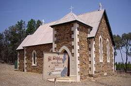 St Stephen's Anglican Church | |
|
Mitta Mitta | |
| Coordinates | 34°53′S 147°51′E / 34.883°S 147.850°ECoordinates: 34°53′S 147°51′E / 34.883°S 147.850°E |
| Elevation | 303 m (994 ft) |
| Location | |
| LGA(s) | Junee Shire |
| County | Clarendon |
| State electorate(s) | Cootamundra |
Mitta Mitta is a farming community in the north eastern part of the Riverina. It is situated by road, about 30 kilometres south from Bethungra and 21 kilometres north east from Nangus.

Mitta Mitta Cemetery
Mitta Mitta is locatable only by finding the old St Stephen's Anglican Church situated 8 kilometres along a corrugated dirt road that runs west from the Nangus to Bethungra road.
The place name Mitta Mitta is derived from the local Aboriginal word meaning "Little Waters".[1]
Mitta Mitta Post Office opened on 1 January 1888, was reduced to a Telephone Office in 1931 and closed in 1936.[2]
References and notes
- ↑ "Mitta Mitta". Geographical Names Register (GNR) of NSW. Geographical Names Board of New South Wales.
- ↑ Premier Postal History, Post Office List, retrieved 2009-06-11
| Wikimedia Commons has media related to Mitta Mitta, New South Wales. |
This article is issued from Wikipedia - version of the 5/8/2016. The text is available under the Creative Commons Attribution/Share Alike but additional terms may apply for the media files.