Goodradigbee River
| Goodradigbee | |
| Little River, Murray Creek | |
| River[1] | |
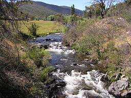 Goodradigbee River in the Brindabella Valley | |
| Name origin: meaning "water running over rocks" | |
| Country | Australia |
|---|---|
| State | New South Wales |
| Regions | Australian Alps (IBRA), Snowy Mountains, Capital Country, Riverina |
| Local government areas | Tumut, Yass |
| Part of | Murrumbidgee catchment, Murray–Darling basin |
| Tributaries | |
| - left | Coleman Creek (New South Wales), Bull Flat Creek, Bramina Creek, Horse Creek (New South Wales), Dinnertime Creek, Limestone Creek (New South Wales), Lousy Gully, Micalong Creek, Wee Jasper Creek |
| - right | Rolling Grounds Creek, Blackfellows Creek, Brindabella Creek, Flea Creek, Betty Brook Creek, Sugarloaf Creek |
| Town | Wee Jasper |
| Landmark | Brindabella Valley |
| Source | Snowy Mountains |
| - location | near Mount Morgan |
| - elevation | 1,650 m (5,413 ft) |
| - coordinates | 35°43′27″S 148°47′29″E / 35.72417°S 148.79139°E |
| Mouth | confluence with the Murrumbidgee River |
| - location | Lake Burrinjuck |
| - elevation | 345 m (1,132 ft) |
| - coordinates | 35°00′S 148°38′E / 35.000°S 148.633°ECoordinates: 35°00′S 148°38′E / 35.000°S 148.633°E |
| Length | 105 km (65 mi) |
| Area | 110,100 km2 (42,510 sq mi) |
| Reservoir | Lake Burrinjuck |
 | |
| [2] | |
Goodradigbee River, a perennial stream[1] that is part of the Murrumbidgee catchment within the Murray–Darling basin, is located in the Snowy Mountains district of New South Wales, Australia.
Course and features

The river rises below Mount Morgan on the northern side of the Snowy Mountains at 1,650 metres (5,410 ft) and flows generally north west, joined by fifteen minor tributaries towards its mouth at the confluence with the Murrumbidgee River at Lake Burrinjuck; dropping 1,300 metres (4,300 ft) over the course of the river's length of 105 kilometres (65 mi).[2]
The majority of the catchment (95%) is forested with the upper catchment within the Kosciuszko National Park. The catchment is 110,100 hectares (272,000 acres) in area. Some water from the upper reaches of the river is diverted into Tantangara Reservoir via an aqueduct, but otherwise the river is not dammed.[3]
In 1968 the National Capital Development Commission considered building a dam at Brindabella Valley for the purpose of sending water into the Cotter River via a tunnel.[4]
The bridge over the Goodradigbee at Wee Jasper was completed in 1896 and is heritage-listed as being an early example of an Allan type timber truss road bridge.[5]
See also
References
- 1 2 "Goodradigbee River". Geographical Names Register (GNR) of NSW. Geographical Names Board of New South Wales. Retrieved 22 January 2013.
- 1 2 "Map of Goodradigbee River". Bonzle.com. Retrieved 25 January 2013.
- ↑ Lintermans, Mark (2002). "Fish in the Upper Murrumbidgee Catchment: A Review of Current Knowledge - Methods" (PDF). Environment ACT. ACT Government. Archived from the original (PDF) on 17 September 2006. Retrieved 1 February 2007.
- ↑ Augmentation of Canberra Water Supply - proposals to utilise the Murrumbidgee and Goodgradigbee Rivers. SMEC Holdings. August 1968.
- ↑ "Wee Jasper Bridge over Goodradigbee River". Heritage and conservation register. Roads and Maritime Services. 29 May 2009. Retrieved 5 April 2014.
External links
- "Murrumbidgee and Lake George catchments" (map). Office of Environment and Heritage. Government of New South Wales.
Rivers of the Murrumbidgee River catchment, New South Wales and the Australian Capital Territory, Australia | |||||
|---|---|---|---|---|---|
| |||||
| |||||