Euberta, New South Wales
| Euberta New South Wales | |
|---|---|
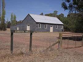 Euberta Hall | |
|
Euberta | |
| Coordinates | 35°04′S 147°13′E / 35.067°S 147.217°ECoordinates: 35°04′S 147°13′E / 35.067°S 147.217°E |
| Population | 379 (2006 census)[1] |
| Postcode(s) | 2659 |
| Elevation | 160 m (525 ft) |
| Location |
|
| LGA(s) | City of Wagga Wagga |
| County | Bourke |
| State electorate(s) | Wagga Wagga |
Euberta is a farming community in the central Riverina area of New South Wales. It is situated on the old Narrandera road with Millwood 6 kilometres to it west and Malebo 9 kilometres to its east. At the 2006 census, Euberta had a population of 379 people.[1] The area is made up of rich pastoral close to the Murrumbidgee River giving graziers the ability to use central pivot and other irrigation systems to grow crops such as Lucerne.
Gallery
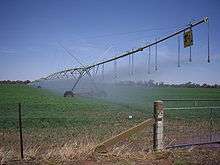 Centre Pivot Irrigation at Euberta
 Centre Pivot Irrigation (close up)
 Homestead at Euberta
 Euberta Telephone Exchange
Notes and references
- 1 2 Australian Bureau of Statistics (25 October 2007). "Euberta (State Suburb)". 2006 Census QuickStats. Retrieved 27 July 2009.
- ↑ Travelmate Archived March 25, 2007, at the Wayback Machine.
| Wikimedia Commons has media related to Euberta, New South Wales. |
This article is issued from Wikipedia - version of the 11/14/2016. The text is available under the Creative Commons Attribution/Share Alike but additional terms may apply for the media files.