Middletown, Maryland
| Middletown, Maryland | |
|---|---|
| Town | |
| Town of Middletown | |
|
Main Street, Middletown | |
 Location of Middletown, Maryland | |
| Coordinates: 39°26′28″N 77°32′38″W / 39.44111°N 77.54389°WCoordinates: 39°26′28″N 77°32′38″W / 39.44111°N 77.54389°W | |
| Country |
|
| State |
|
| County |
|
| Area[1] | |
| • Total | 1.74 sq mi (4.51 km2) |
| • Land | 1.74 sq mi (4.51 km2) |
| • Water | 0 sq mi (0 km2) |
| Elevation | 564 ft (172 m) |
| Population (2010)[2] | |
| • Total | 4,136 |
| • Estimate (2012[3]) | 4,247 |
| • Density | 2,377.0/sq mi (917.8/km2) |
| Time zone | Eastern (EST) (UTC-5) |
| • Summer (DST) | EDT (UTC-4) |
| ZIP code | 21769 |
| Area code(s) | 301 |
| FIPS code | 24-52425 |
| GNIS feature ID | 0585831 |

Middletown is a suburban town in Frederick County, Maryland, United States. The population was 4,136 at the 2010 census. Located in the Middletown Valley that stretches between the Catoctin Mountains on the east and South Mountain on the west, the town reportedly gained its name from its location midway between those ranges.
History
A young Lieutenant George Washington, while surveying the South Mountain area, reported that the valley to the east was one of the most beautiful places he had ever seen. Later, as a Colonel in 1755, he was to accompany General Braddock on the old Indian Trail that ran through the valley on his way to Fort Cumberland.
The early German and English settlers started to arrive in the valley in the 1730s. Among them was Michael Jesserong, who paid £66 for 50 acres (200,000 m2). He named his property Middletown and sold the first lots there in 1767, the date officially marked as that of the town’s founding.
The history of Middletown is a mirror on the nation’s development. Main Street spread to the west with construction of the National Pike through the town in 1806; the telegraph lines from Frederick to Hagerstown were routed through Middletown in 1854; and in 1896, car 11 of the Frederick Middletown Railway made its first run to Middletown. During the Civil War, both armies passed through the town to the battles of South Mountain and Antietam. In the aftermath of those battles, Middletown opened its churches and homes to care for the wounded.
Geography
Middletown is located at 39°26′28″N 77°32′38″W / 39.44111°N 77.54389°W (39.441155, -77.543761).[4]
According to the United States Census Bureau, the town has a total area of 1.74 square miles (4.51 km2), all of it land.[1] Catoctin Creek (Maryland) flows due south from about one mile west of town to several miles south of town.
To the east, it borders Braddock Mountain, named after the British general Edward Braddock. The mountain itself, along with its community, Braddock Heights, is often said to be the roost of the mythical Snallygaster, a bird/dragon creature said to abduct livestock and people from the surrounding valley.
Demographics
| Historical population | |||
|---|---|---|---|
| Census | Pop. | %± | |
| 1870 | 746 | — | |
| 1880 | 705 | −5.5% | |
| 1890 | 667 | −5.4% | |
| 1900 | 665 | −0.3% | |
| 1910 | 692 | 4.1% | |
| 1920 | 749 | 8.2% | |
| 1930 | 818 | 9.2% | |
| 1940 | 839 | 2.6% | |
| 1950 | 936 | 11.6% | |
| 1960 | 1,036 | 10.7% | |
| 1970 | 1,262 | 21.8% | |
| 1980 | 1,748 | 38.5% | |
| 1990 | 1,834 | 4.9% | |
| 2000 | 2,668 | 45.5% | |
| 2010 | 4,136 | 55.0% | |
| Est. 2015 | 4,469 | [5] | 8.1% |
2010 census
As of the census[2] of 2010, there were 4,136 people, 1,484 households, and 1,166 families residing in the town. The population density was 2,377.0 inhabitants per square mile (917.8/km2). There were 1,569 housing units at an average density of 901.7 per square mile (348.1/km2). The racial makeup of the town was 91.9% White, 2.8% African American, 0.3% Native American, 2.8% Asian, 0.1% Pacific Islander, 0.6% from other races, and 1.6% from two or more races. Hispanic or Latino of any race were 3.1% of the population.
There were 1,484 households of which 45.3% had children under the age of 18 living with them, 64.8% were married couples living together, 10.4% had a female householder with no husband present, 3.4% had a male householder with no wife present, and 21.4% were non-families. 18.1% of all households were made up of individuals and 7.6% had someone living alone who was 65 years of age or older. The average household size was 2.79 and the average family size was 3.16.
The median age in the town was 39.6 years. 29.9% of residents were under the age of 18; 6.5% were between the ages of 18 and 24; 23.2% were from 25 to 44; 29.7% were from 45 to 64; and 10.6% were 65 years of age or older. The gender makeup of the town was 48.8% male and 51.2% female.
2000 census
As of the census[7] of 2000, there were 2,668 people, 960 households, and 728 families residing in the town. The population density was 1,577.3 people per square mile (609.5/km²). There were 981 housing units at an average density of 580.0 per square mile (224.1/km²). The racial makeup of the town was 96.89% White, 1.46% African American, 0.07% Native American, 0.34% Asian, 0.22% from other races, and 1.01% from two or more races. Hispanic or Latino of any race were 0.82% of the population.
There were 960 households out of which 44.6% had children under the age of 18 living with them, 63.6% were married couples living together, 8.6% had a female householder with no husband present, and 24.1% were non-families. 18.9% of all households were made up of individuals and 8.9% had someone living alone who was 65 years of age or older. The average household size was 2.78 and the average family size was 3.21.
In the town the population was spread out with 32.0% under the age of 18, 5.4% from 18 to 24, 29.9% from 25 to 44, 21.7% from 45 to 64, and 11.0% who were 65 years of age or older. The median age was 36 years. For every 100 females there were 91.8 males. For every 100 females age 18 and over, there were 87.6 males.
The median income for a household in the town was $67,266, and the median income for a family was $80,115. Males had a median income of $48,864 versus $31,602 for females. The per capita income for the town was $25,759. About 1.8% of families and 3.0% of the population were below the poverty line, including 2.1% of those under age 18 and 8.5% of those age 65 or over.
Notable people
- Charlie “King Kong” Keller: 5x Major League Baseball All-Star for New York Yankees and Detroit Tigers, 4x World Series champion
- Hal Keller: Major League Baseball player, vice president/general manager of Seattle Mariners
- Amber Theoharis: reporter for MASN/Baltimore Orioles, co-host NFL Network
- Scott Devours: drummer with Roger Daltrey
References
- 1 2 "US Gazetteer files 2010". United States Census Bureau. Retrieved 2013-01-25.
- 1 2 "American FactFinder". United States Census Bureau. Retrieved 2013-01-25.
- ↑ "Population Estimates". United States Census Bureau. Retrieved 2013-06-26.
- ↑ "US Gazetteer files: 2010, 2000, and 1990". United States Census Bureau. 2011-02-12. Retrieved 2011-04-23.
- ↑ "Annual Estimates of the Resident Population for Incorporated Places: April 1, 2010 to July 1, 2015". Retrieved July 2, 2016.
- ↑ "Census of Population and Housing". Census.gov. Retrieved June 4, 2015.
- ↑ "American FactFinder". United States Census Bureau. Retrieved 2008-01-31.
External links
| Wikivoyage has a travel guide for Middletown (Maryland). |
Municipalities and communities of Frederick County, Maryland, United States | ||
|---|---|---|
| Cities | 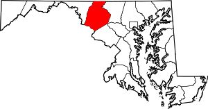 | |
| Towns | ||
| Village | ||
| CDPs | ||
| Other communities |
| |
| Footnotes | ‡This populated place also has portions in an adjacent county or counties | |
| Principal cities |
| |||||||||||
|---|---|---|---|---|---|---|---|---|---|---|---|---|
| Counties and county equivalents* |
| |||||||||||
The District of Columbia itself, and Virginia's incorporated cities, are county equivalents. Virginia's incorporated cities are listed under their surrounding county. The incorporated cities bordering more than one county (Alexandria, Falls Church and Fredericksburg) are listed under the county they were part of before incorporation as a city. | ||||||||||||